Guixeres Landscape Recovery
Basic information
Project Title
Full project title
Category
Project Description
The project develops a section of the Igualada’s Green Ring,through the old gypsum mines of the town,a space abandoned for decades.The landscape recovery of the place starts by creating a scenic path that crosses the area.The layout of this linear viewpoint recognizes the existing landmarks and trees by widening and creating rest areas.Despite the austerity of the proposal,there is an improvement in the bioclimatic conditions achieving a place to walk,rest,learn and enjoy the territory.
Project Region
EU Programme or fund
Description of the project
Summary
The work is framed within Igualada’s Green Ring global project, aiming at creating a set of pedestrian and bicycle paths as a green belt around the perimeter of the city. This new green sustainable mobility infrastructure aims at establishing a network of perimeter free spaces, apt for environmentally friendly leisure activities, adapting and recovering, to great extent, currently underused or degraded spaces. In this context, the gypsum mines path implies the adaptation of a 1,65km section, of which 800 meters have already been accomplished.
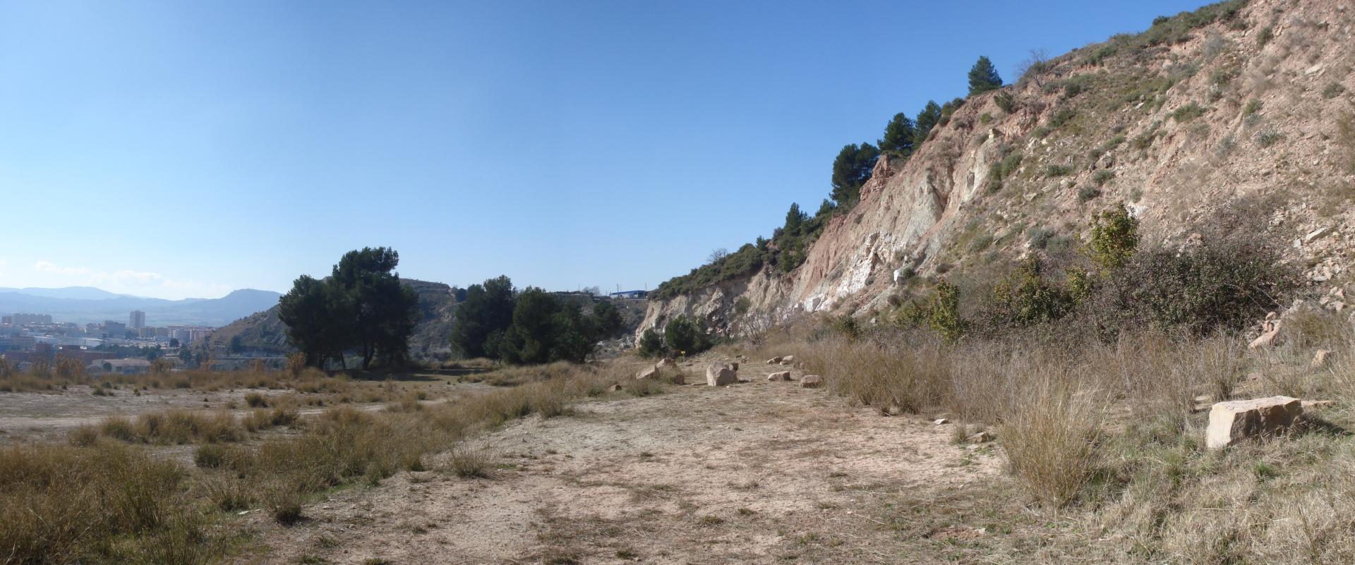
The path runs through a highly degraded natural space on the northern area of Igualada. The area was subject to an intense extractive activity to remove the gypsum from its subsoil (Claret and Pelfort gypsum mines). Once this activity ceased, the area was used as a municipal waste transfer station. Towards the late 70s this activity also ceased and the area was abandoned without any type of recovering or mending action.
The project has two main goals: first, connectivity, achieving the continuity of this global project around the whole city (the green ring). Second, landscape and biodiversity recovery, establishing the necessary elements to generate a new dynamic on the site that will progressively improve its environmental conditions using collected water.
Key objectives for sustainability
The proposal’s great challenge lies in the technification of conventional solutions for path construction, in order to accomplish greater performance regarding accessibility, visibility, durability and re naturalization of the environment, with an optimum cost ratio and maximum efficiency regarding environmental footprint.
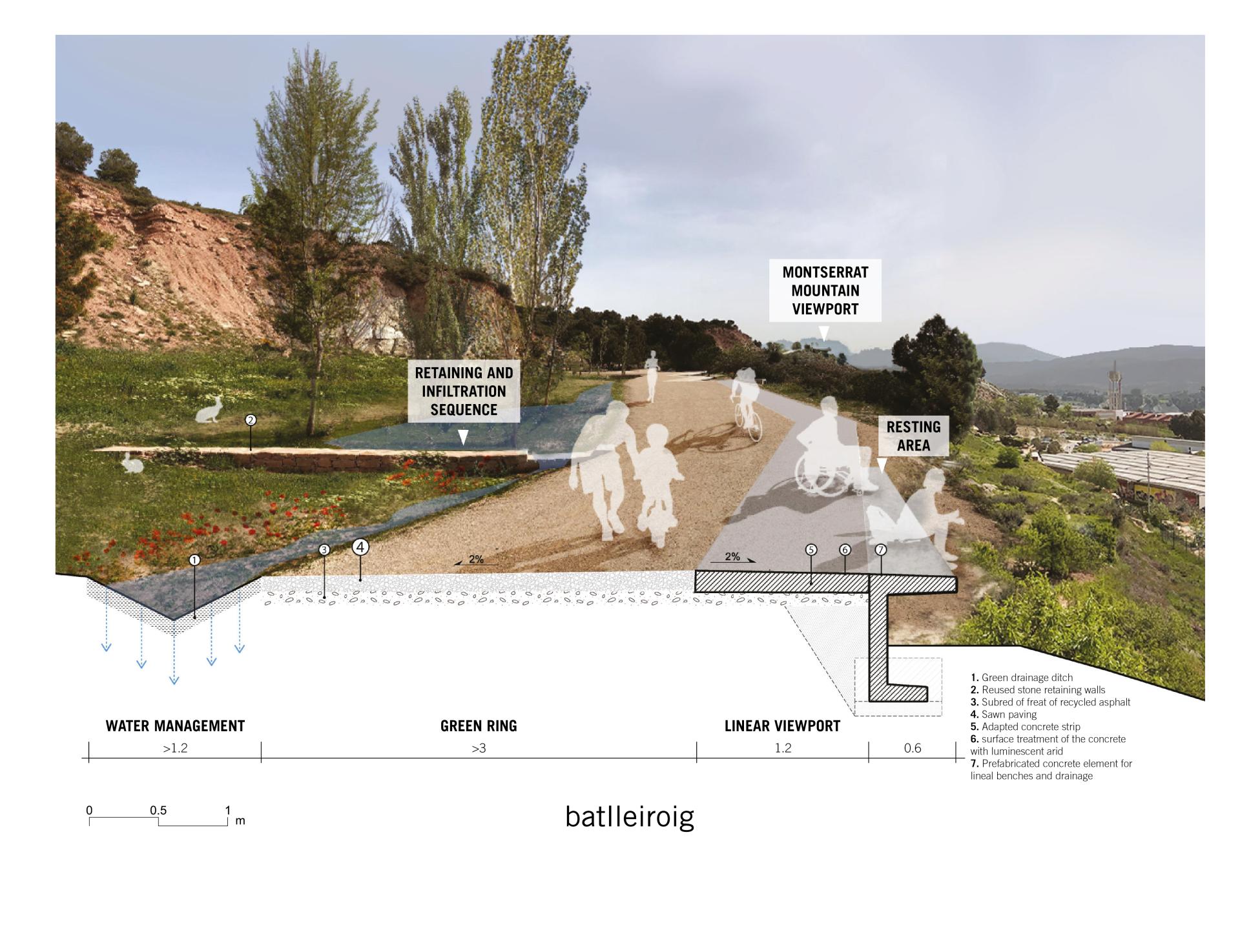
The path’s technification improves its performance over conventional solutions and helps regenerate and re-naturalize the surroundings. The draining system proposed through ditches and retaining areas allows for a bolder re-naturalization of the surroundings taking advantage of runoff water. Good water control prevents erosion on the road and reduces maintenance.
Key objectives for aesthetics and quality
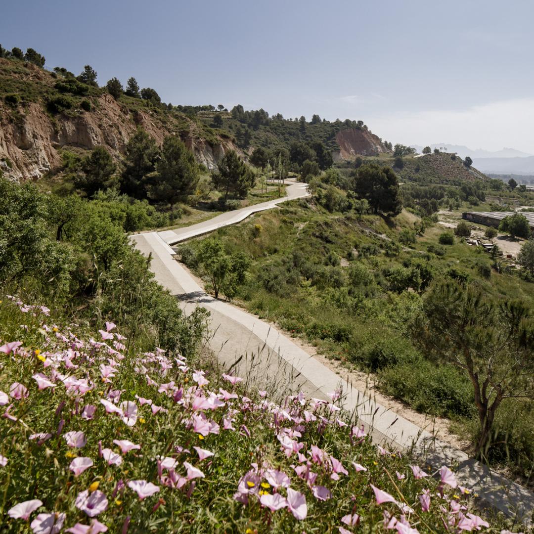
The proposal uses the existing platform to configure this new section of the green ring. It’s path is mainly laid out over the exterior gradient to foster views over the city of Igualada. The geometry deployed for the proposal enables the new path to adapt perfectly to the inconsistencies of the platform while it can come close to the existing vegetation and shadows or foster certain viewpoints. At the same time, the path is completed with several small living areas strategically placed on the most privileged areas. This section of the path ends in a final observation deck cantilevering over the mountain providing a panoramic view of the Anoia and Montserrat Mountain.
Solving the issues with water and inclusiveness, part of the path’s surface can be aggregate. The proportion between both allows the road to continue having a soft nature, appropriate for its context. At the same time, it supposes an extremely efficient use of materials.
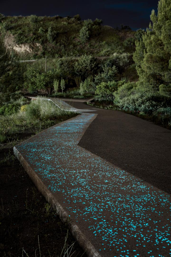
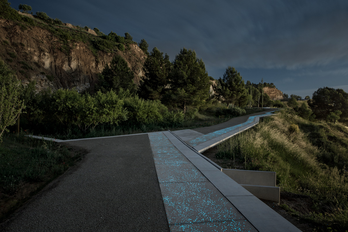
The concrete fringe, completed with benches, becomes a linear observation deck along the whole path. It has the minimum width possible, 1.2 meters, to allow for a correct accessibility and inclusiveness. The concrete’s composition includes luminescent aggregate. This material harvest solar energy during the day and it gives it back at nighttime as luminescent energy. It is not light, but it those create a subtle luminous effect that can guide the path during the first hours of the night.
Key objectives for inclusion
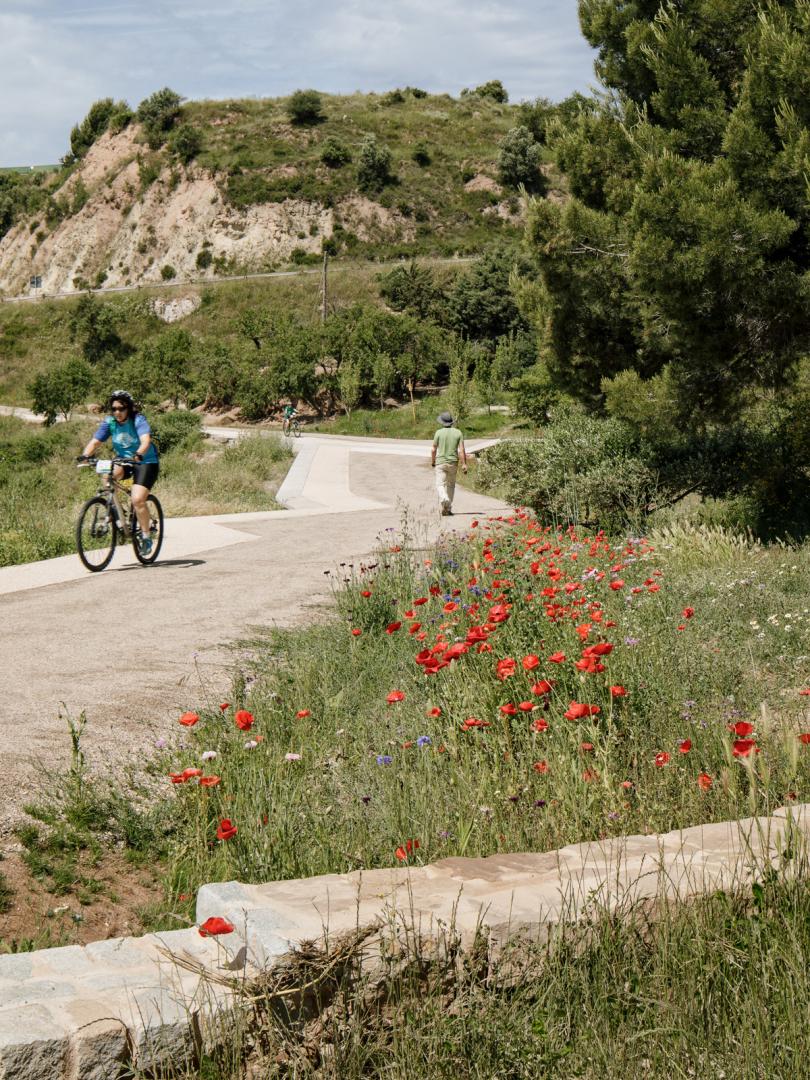
The project continues the Igualada Green Ring through the area by means of a path with a minimum width of 3 m. This width is enough to have a correct accessibility and coexistence between the different active mobility users.
The proposal slightly adjusts the slope of the path to try to obtain acceptable longitudinal slopes. The technical solution of the road ensures a greater durability of the pavement without it being damaged by runoff (the appearance of this type of erosion significantly reduces accessibility on conventional roads). Also, the inclusive strip, in the form of a concrete strip of 1.2 m, enables accessibility to the route for certain groups of people who require hard pavements. On the other hand, the edge of this paved band allows it to be followed by the blind throughout the entire route.
Results in relation to category
The proposal is located in a natural environment highly degraded by extractive activity and in a clear state of abandonment on the edge of the urban area of the municipality. Its integration within the Green Ring gives this space a new opportunity and is the excuse to start its environmental and landscape recovery.
The new itinerary becomes a place of public attendance where citizens can find a place to walk, run or cycle and at the same time take advantage of being able to enjoy the views that the place has over the city and the Montserrat mountain.
How Citizens benefit
For years, there had been a repeated demand from the public to recover and transform this degraded area. Its history, its potential views and even some pre-existing trails did not go unnoticed by an important part of its inhabitants, eager for new spaces where they can do sport in contact with nature.
The work of the City Council in defining the route of the Green Belt and the inclusion of this area as a main part sought to respond to this social demand. Through the execution of the project, a natural space has been recovered, achieving the continuity of this itinerary of long journey and at the same time a series of elements have been established that improve the environmental conditions of the place thanks to the use of rainwater.
Innovative character
Water is a valuable resource to be managed with intelligence. According to this idea, the proposal lays out a new draining system that on top of controlling superficial waters, aims at taking advantage infiltrating most of it into the terrain to generate new humid areas.
A vegetable ditch follows the whole path collecting water from the hill’s slope and the path itself. Along this ditch we can find a number of humid spots where vegetation can develop with greater determination. This is achieved via construction of a number of stone walls aiming at retaining and foster runoffs, reducing erosion and allowing the infiltration of the soil’s water. Water becomes one more of the path’s building material along time, becoming the catalyst of the place’s re-naturalization.
The construction of this walls is done using boulders coming from small landslides. At the same time, an illegal debris landfill found within the site at the beginning of the construction works provided enough granite cobblestones to produce the walls’ capstones.
The low spots of the proposal, on top of becoming retention and infiltration areas require overflow channels that allow to evacuate excess water on exceptional rain episodes. These elements are done with the same prefab concrete elements that create the benches, together with a second one that allows to close the channel.
Finally, a fraction of luminescent aggregate was included in the concrete composition of the accessible strip to give this subtle effect during the early hours of the night, achieving a surprise effect but at the same time an improvement in road performance, since it enables more hours of use.