Move It!
Basic information
Project Title
Full project title
Category
Project Description
Move it! aims to transform the streets of Brussel from car-centric to ecosystem-oriented, by designing the necessary protocols for the democratization of public space and designing desirable built objects of reappropriation. The process encompasses the scale of parametric planning and the scope of citizen participation. We all become co-curators of our streets by being given the tools to act and mediate our future of public space, a collective space of encounters, starting at our front doors.
Project Region
EU Programme or fund
Description of the project
Summary
Today, cars occupy a hegemonic place in Brussels as 70% of its public space is reserved for automobiles. Recently, awareness around soft mobility has raised, presaging a decline in the absolute dependence for private cars. There is a collective reckoning that our cities have been designed for a past that is not reflecting how we want/ought to live and increasing awareness alternative realities are possible.
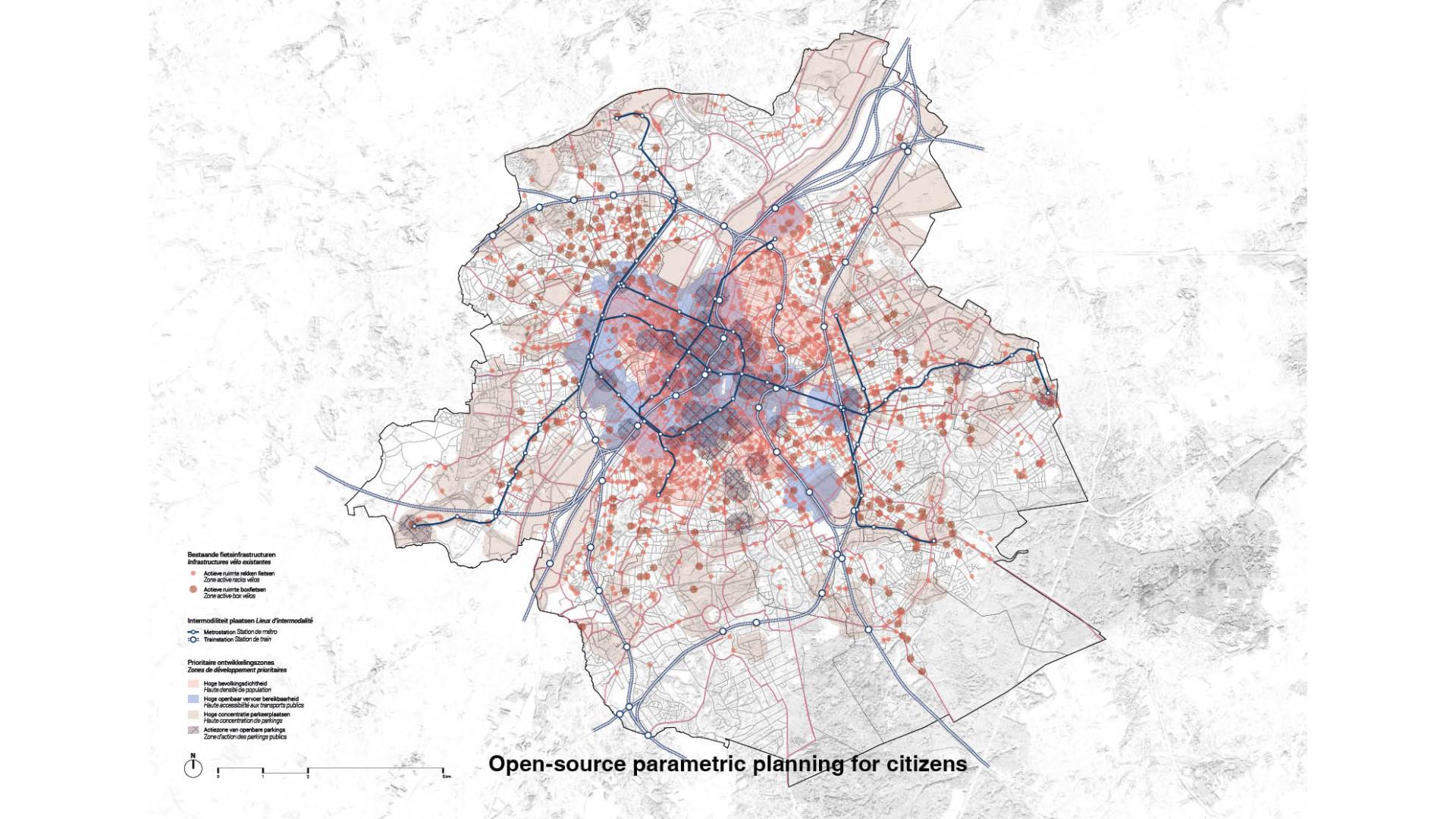
In this context, a new type of urban intervention emerges; those aimed at reallocating parking spots to public space designed for/by people. Often, these interventions are received skeptically by institutions as they are assumed to be time intensive to implement or not scalable. The process we propose is to combine the scale of centralized planning, with parametric geo-localized analysis, with the scope of citizen participation, by inviting citizens to be part of the shaping of public space starting at their doorstep.
A comprehensive geography of challenges citizens are facing is drawn, street by street, using parametric geo-spatial tools. Existing trees, need of bike infrastructures, or lack of urban furniture can be measured. Each parking spots of the city is being allocated a program forming an alternative reality that people can grasp and be inspired to claim ownership.
Citizens are invited to take part in the shaping of their own street using the map as a reactionary common ground. No one else than the people living in that street knows how the place feels across days and seasons, and what they are lacking to thrive. They become an integrative part of the shaping of their own environment, and the public space, once its fate siloed in the hands of the institutions, becomes a projection of themselves.
The result is an integrative space in its matter, as cars leaves room for life, and in its process, as planning is complemented by participation, built on collective intelligence. The public space is produced by the very people affected by it: us!
Key objectives for sustainability
The proposal aims to reclaim public space, change mobility patterns, reintroduction of vegetation, not in a “big plans” modernist approach but in a distributed constellation of micro interventions.
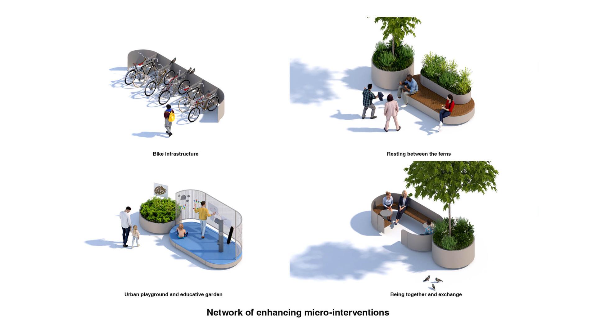
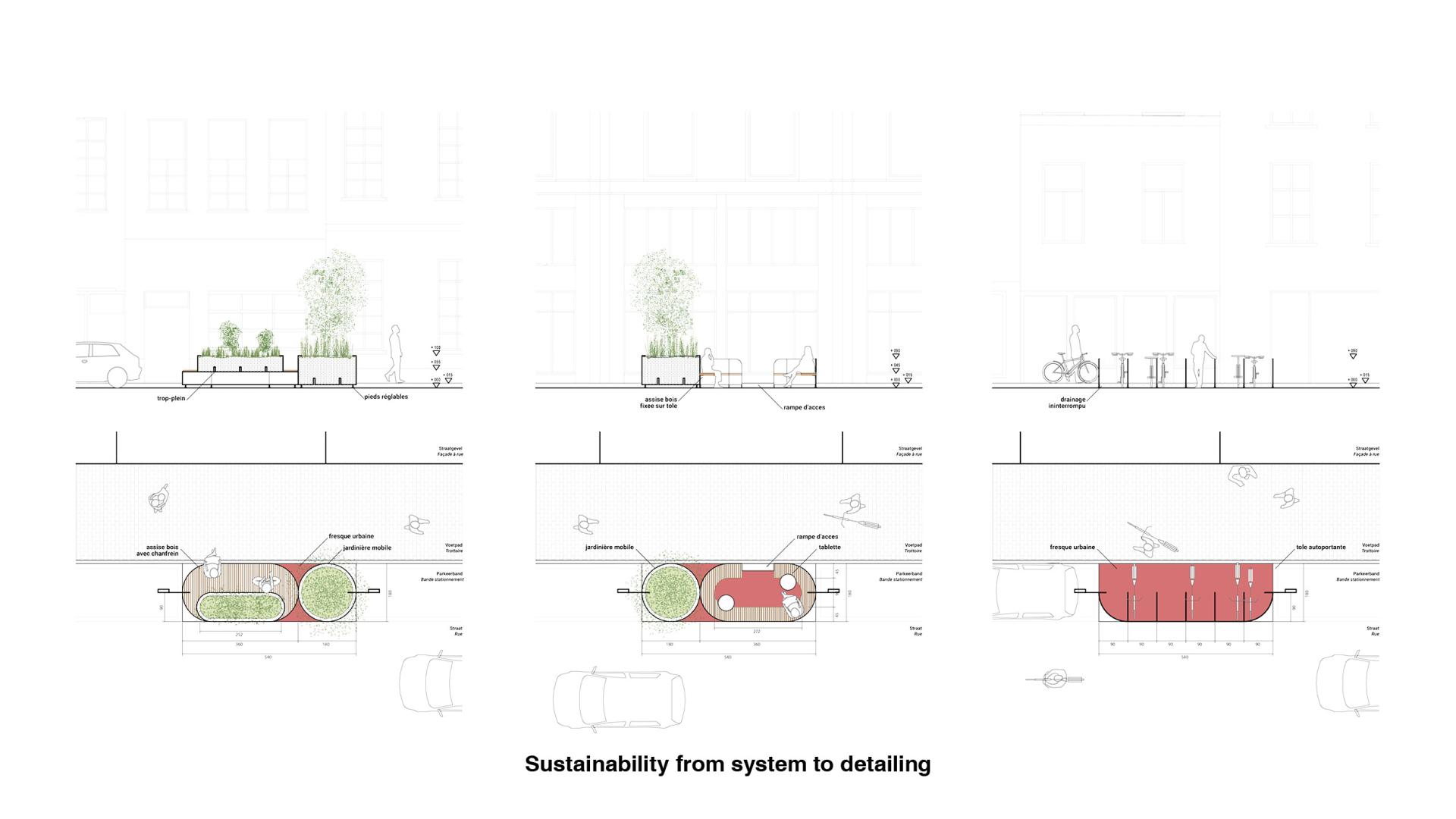
The replacement of car parking follows two principles: decentivization of car use and incentivization of soft mobility use. The amount of on-street car parking is being reduced by providing bike infrastructure, such as bike parking, pumps and small repair points, as well as trees and urban furniture. The provision of bike infrastructure promotes the use of bicycles and other soft mobility modes of transport to go around the city. Also, the reduction of car parking makes car usage less convenient.
Environmental sustainability, while being a major aspect of the intervention, is a by-product of the process. Public space is being placed back at the center of the life of people and the process is centered around them, their needs, their inspirations. The shift of mobility behaviors is not super-imposed but rather a logical extension of their own implication in co-designing an environment where they would thrive.
Citizens become co-curator of their local program. Their front door becomes the first node of a hyper local urban program. Naturally, it will decrease the need for car trips as the hyper-local context is providing inhabitants with the necessary infrastructure and programs. Increasing the number of plants and the creation of a continued green infrastructure network are some of the active actions to promote bio-diversity and insert nature around each corner of the city, not only in dedicated parks. This is the first step to a 15-minute city.
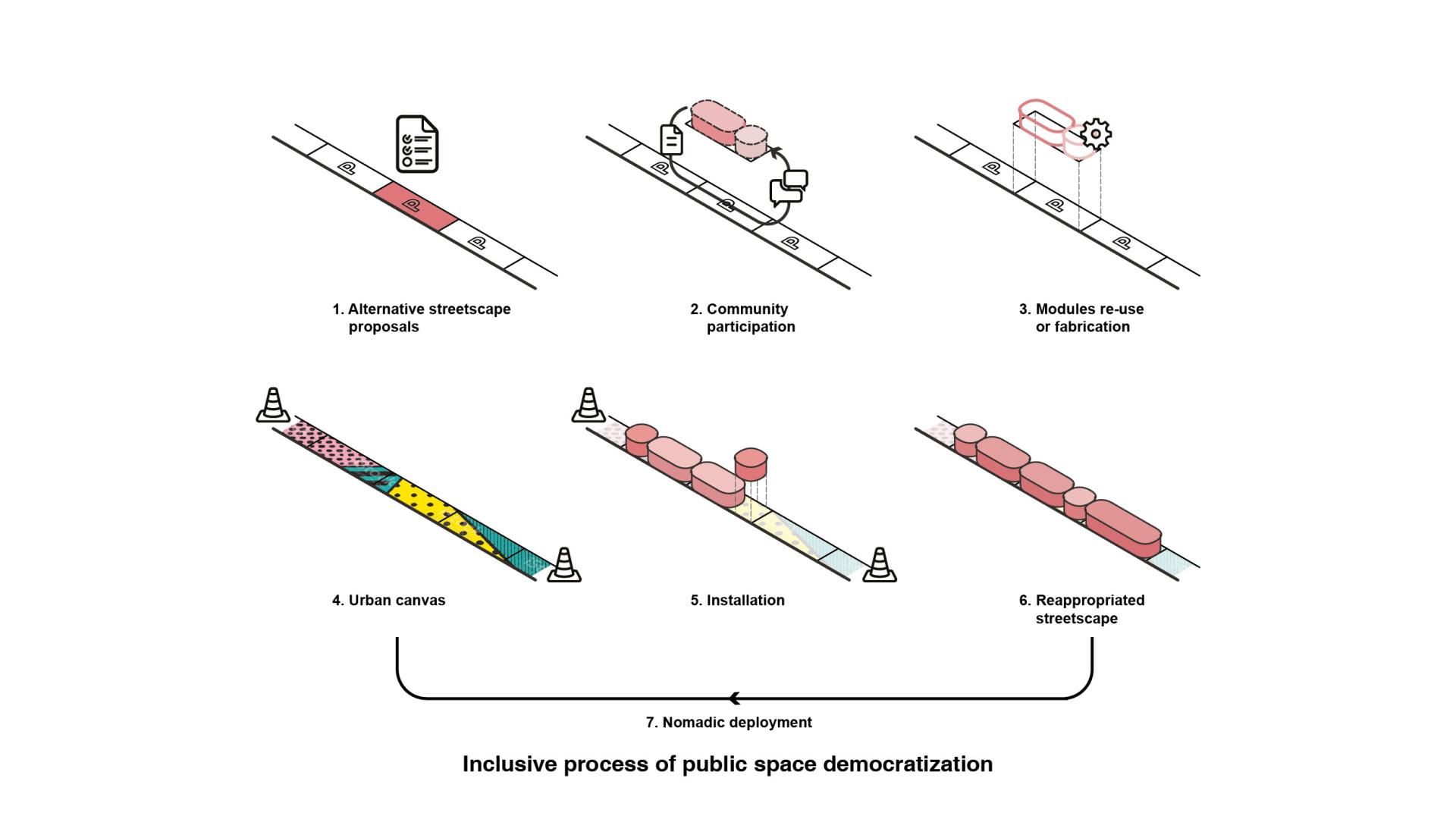
Finally, the modules are considered to be a first temporary intervention in the public space. They serve as a testbed for the long-lasting intervention in the streetscape. The built modules are designed to be durable and transportable, pollinizing the city across time and space, sustainable in its composition and deployment.
Key objectives for aesthetics and quality
At the core of the proposal, there is the need to provide the matter with which citizens will feel invited to project themselves. Move it! is as much about designing the necessary protocols for the democratization of public space, as designing a desirable built environment that is inspiring and inviting to be a part of.
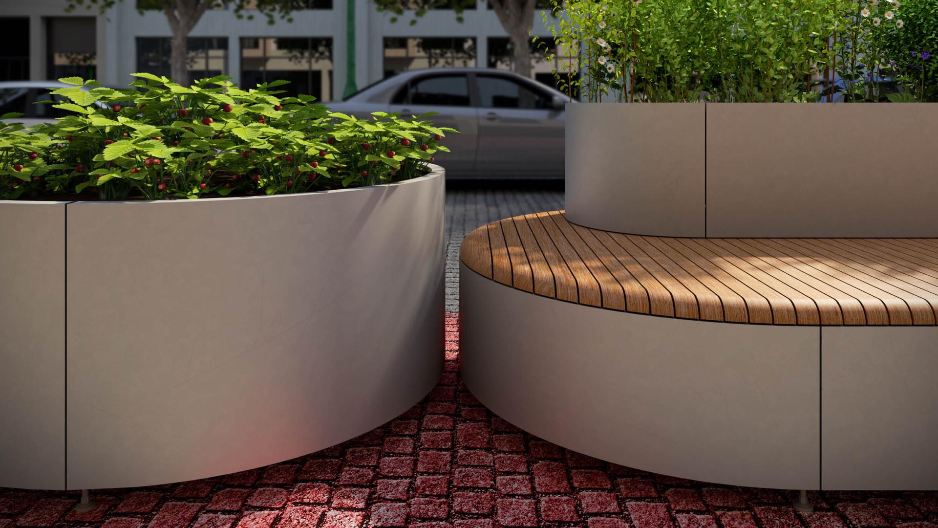
Existing proposals of similar modules, called parklets, are centered around the idea of temporality, but citizens involvement in their public space ought to project durability. The design of the modules reflects the operating systems in which we designed them to operate. As the modules will be transported across the city, activating streets and people along their way, they need to be durable in their matter and forms, outside of the aesthetical realm of the temporary.
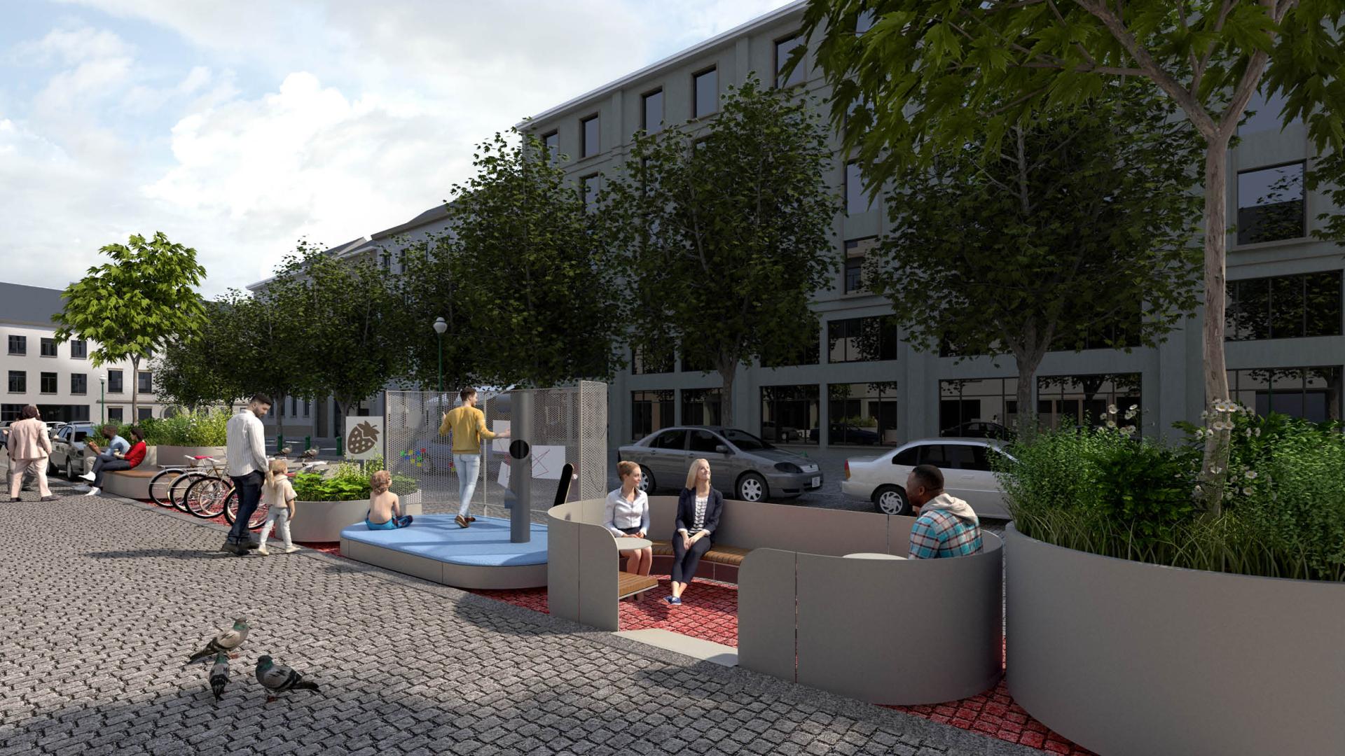
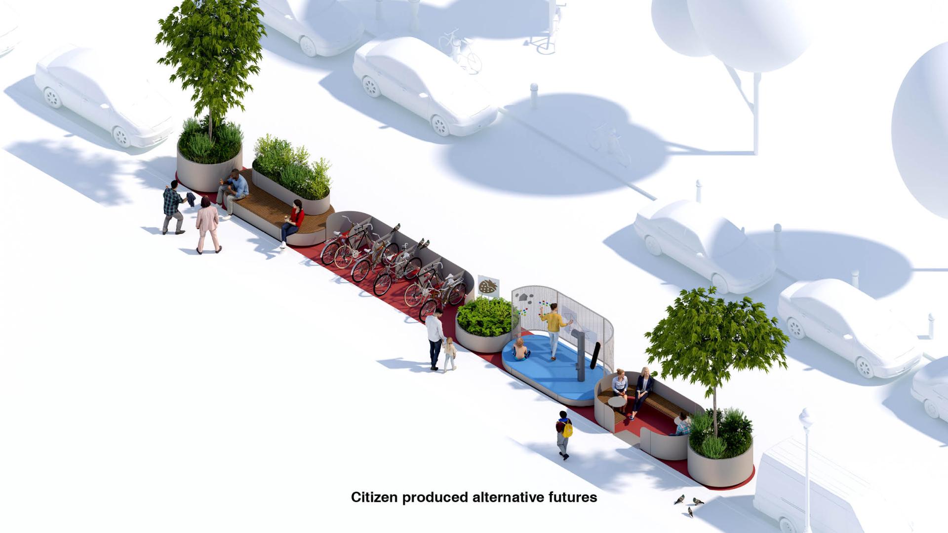
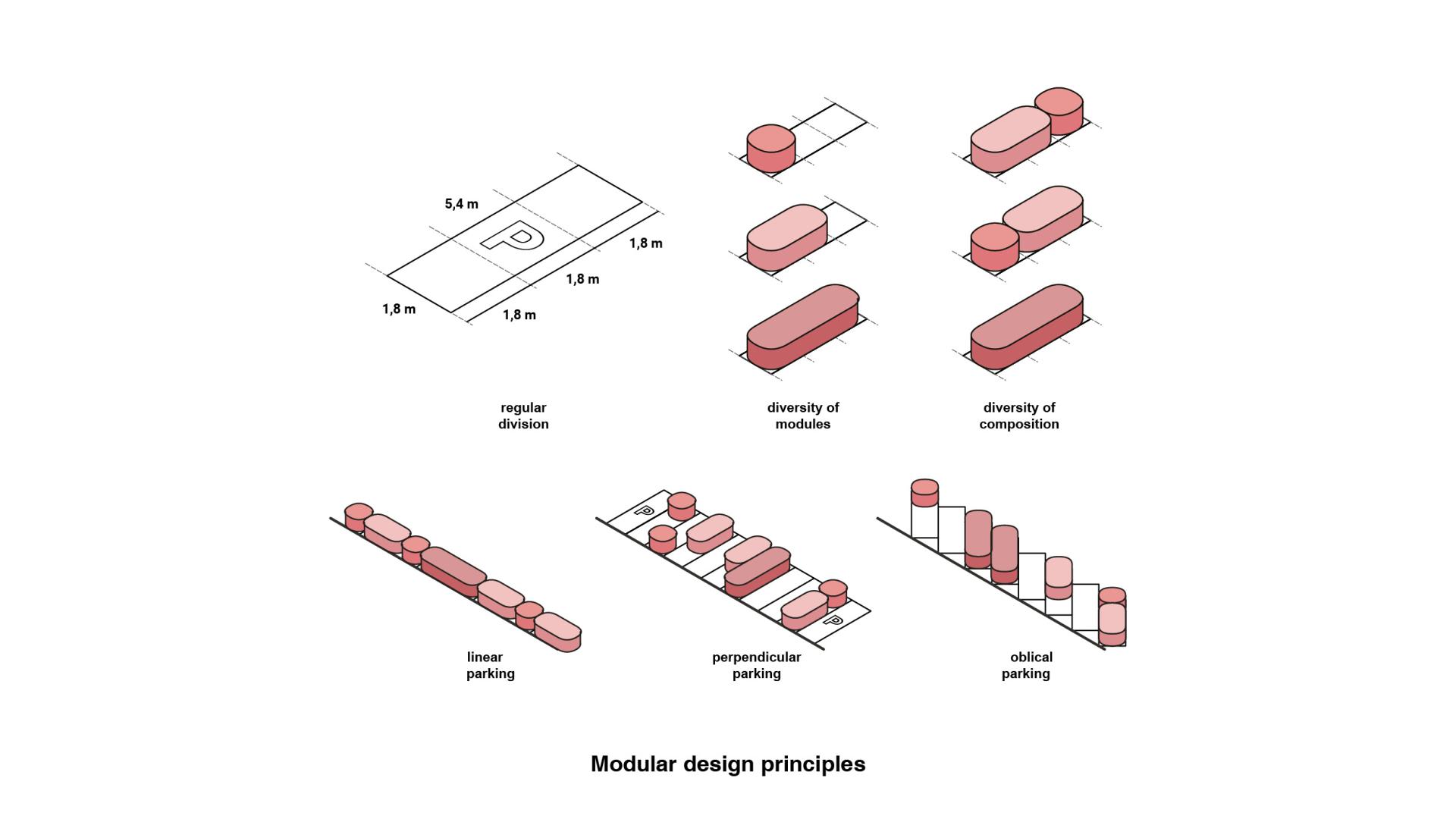
If we must reimagine public space away from car, it would be a mistake to extrapolate it rigidly from a car parking spot dimension. It would be another way of showing how public space is being shaped by cars. Instead of designing a set of modules that would perfectly fit a car spot, the design of Move it! is split it into sub-elements that can be freely combined. The public space becomes a combination of architectural elements, standing in space, representing the diversity of the people living around them and the multiplicity of their needs.
Simple forms and lines which are not entangled to a specific architectural style in time and space. This is the driving force behind the design choices. As they will be used in vastly different contexts of the city, they need to have a certain level of abstraction into which people can project what they see for themselves. For each location of intervention, the floor becomes a canvas that is entirely free for expression for each community.
The combination is a reflection of the thinking of our time: visual sustainability which offers flexibility for appropriation and interpretation.
Key objectives for inclusion
Move it! is grounded onto a fairer use of urban spatiality and the collective participation in the shaping of space. Inclusivity of design is necessary but not enough for a truly inclusive city; inclusive process is an essential part of better and fairer cities.
In its process, communities are asked to be part of their direct environment. They become co-designer of the public space at their front-door. Digital tools can be used a facilitator to mobilize people around a specific intervention. Based on interactive tool, anyone can propose alternative streetscapes for the street where they live in. They can share it to their neighbors and inspire each other to create their own street full of modules fulfilling a range of functionalities. This will create the necessary social cohesion and power to show to institutions that the will of the people to act is present and canalized. Once mobilized, workshops are organized to give a space to all to express their needs and concerns. People are invited to use a physical model of their street as a game mediating the different opinions and needs. The result is a combination of modules arranged according to the functionalities expressed as necessary and articulated in a composition of successive modules clustered together.
In each neighborhood, the implementation of the intervention needs to be embedded into the existing social and civic fabrics. The floor onto the succession of modules are placed, once car parking spots, becomes a canvas onto which communities are asked to creatively express their vision of their street. Children living in this street, local artists, nearby school, neighbor association, can project on this urban canvas an extension of their social values and aspirations.
As every street is composed of different beings and personalities, each of the location of intervention is resulting into a different composition of functions and representation.
Innovative character
Parklets is not an innovative urban intervention in itself nor new, as it appeared in the early 2000’s in the US. They were imagined as a bottom-up approach to take over car parking spots as a temporary reallocation towards terraces and public benches. It was up to the tenant or owner of the adjacent building to under-go the permit and design process, which made it time extensive and create a burden and thresholds for wider use of the system.
The process we propose is to combine the scale of centralized intelligent planning, with parametric geo-localized analysis, with the scope of citizen participation, by inviting citizens to be part of the shaping of public space starting at their doorstep.
The use of digital planning and interactive tools reduce the threshold for action as the information system is democratized. A public space that is fairer and more inclusive needs to be democratic and to be accessible to all. Putting the planning tools in the hands of the many will pressure the institutions for actions in the place that are needed and not only to where the few decide it is the most suited. It becomes a collaborative spatial planning.
With the development of digital technologies, the marginal costs are dramatically reduced and with smart planning it allows to unfold an alternative future of public space where all of us are invited to take part in.