"I Prati del Ceppo" flooding ecosystem
Basic information
Project Title
Full project title
Category
Project Description
The project was designed to mitigate the flooding phenomena which affect the metropolitan area of Milan during intense rains, which are more and more frequent and extreme as a result of climate change and soil sealing. A permanent wetland with hygrophilous vegetation has been created thanks to two basins designed to collect water from the stream in the event of flooding and to the adjacent pond fed with groundwater. The natural park became a loved new destination for flora, fauna and people.
Project Region
EU Programme or fund
Description of the project
Summary
The Lura river is part of the River Contract “Olona-Bozzente-Lura”, the first one signed in the Lombardy Region in 2004. The protection and regeneration of the river axis represents an important opportunity for the sustainable development of the metropolitan area of Milan and of the many Municipalities that have settled along the rivers, with their rural and urban fabric. The Lura, as well as the Olona river, represents a physical link for these municipalities, capable to trigger virtuous processes of co-design, supporting the policies and the initiatives aimed at consolidating resilient river communities, in order to remedying and mitigating the pressures due to unregulated urbanisation.
The project Lura River Retention Basins is conceived for the need to contrast the flooding phenomena that occur in the Milan metropolitan area during periods of heavy rainfall, compensating for the massive presence of sealed urban areas and for the increasingly evident and damaging effects of climate change. The project is also part of a supra-regional hydro-geological risk reduction strategy promoted by the Interregional Agency for the Po River (AIPO) and the Lombardy Region.
The project therefore represents an opportunity to highlight the fundamental role of nature in intervening against climate change, in multiple urban and rural contexts. The project area involved a monofunctional agricultural area and wooded strips with low ecological value, located between the municipalities of Lomazzo, Cadorago and Bregnano within the Lura Park.
Key objectives for sustainability
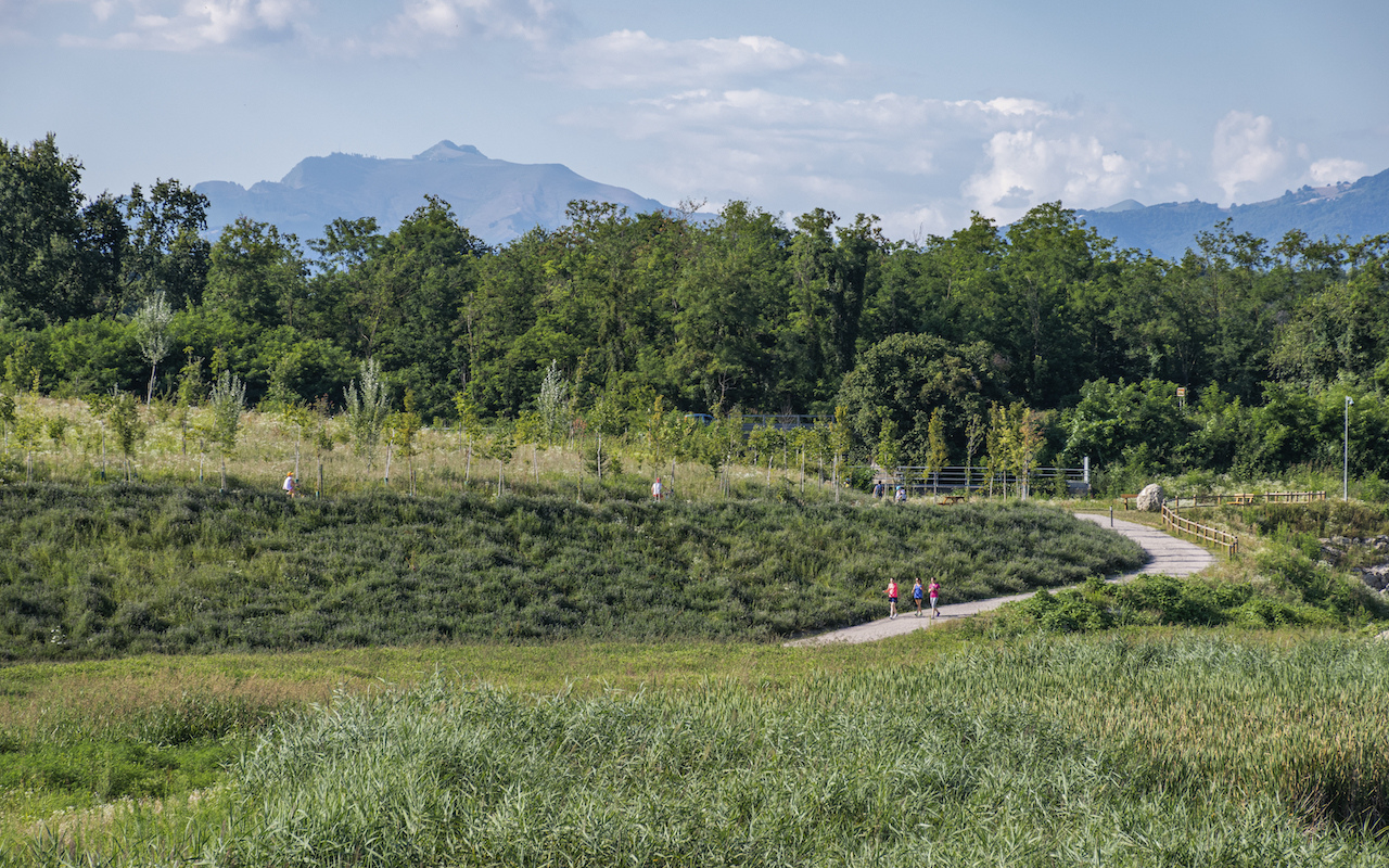
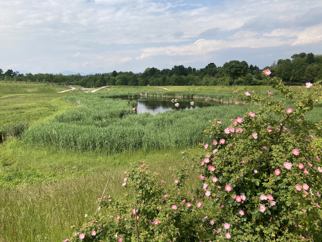
The regeneration work carried out on an area of 20 hectares, with the main purpose of controlling and limiting the phenomena of river overflowing, becomes an opportunity to promote a sustainable development and a sustainable lifestyle, highlighting the need of an integrated urban and suburban planning to reduce the environmental impact of human being. Water is not a problem to be solved, but becomes the protagonist of the project, through the provision of three different water basins that characterize the entire area of intervention: two of these designed to collect temporarily the water of Lura in case of flood, the third is a permanent pond fed with groundwater. The latter basin with hygrophilous vegetation allows to integrate within the project the objective of enhancing the biodiversity and the ecological value, creating an ideal habitat for the settlement of various animal species. New animal species were, indeed, appeared near the river after the intervention. In addition to the construction of the three basins, reforestation measures were implemented with 35,000 sqm of woodlands and 12,000 new trees. This creates an area of high environmental quality, capable of excellent performance in terms of pollution and carbon sequestrations, with positive effects on the entire local macro-climate. In line with a sustainable approach to the project, and in order to limit the amount of sealed surfaces, the project was realized with no soil and land consumption, thanks to the reuse of excavated earth to readjust the topography, work on the riverbanks and reshape the entire project area.
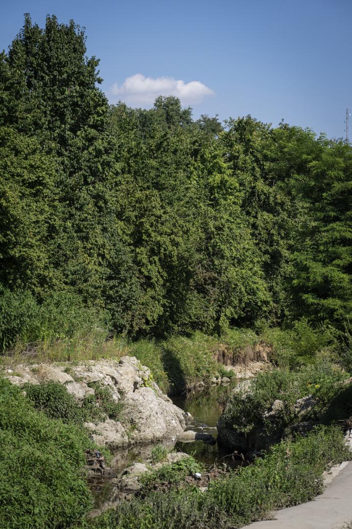
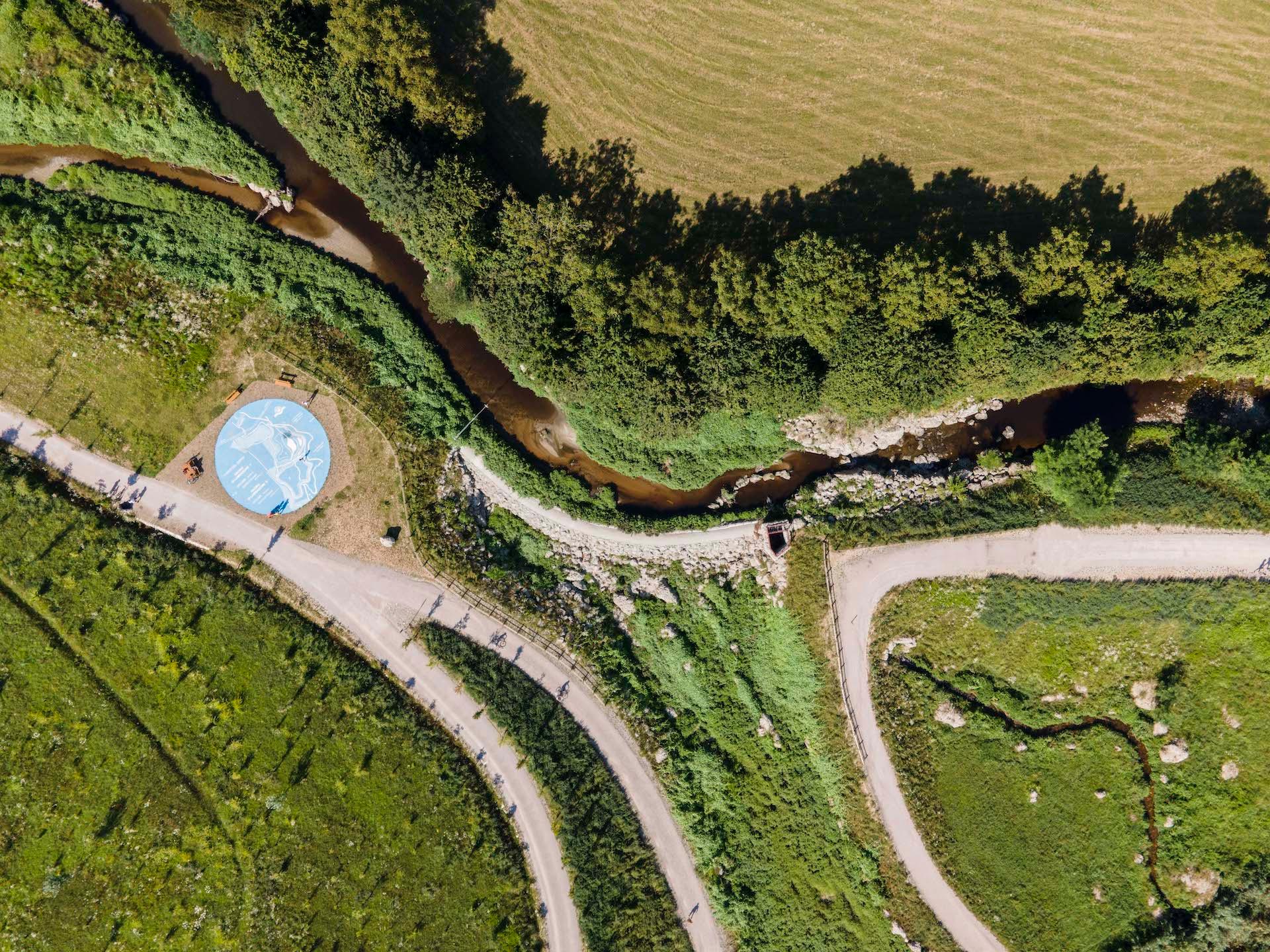
The intervention consists of the construction, using naturalistic engineering techniques, of new banks and flood amination basins along the course of the river Lura. A permanent wetland with hygrophilous vegetation has been created thanks to two basins designed to collect water from the stream in the event of flooding and to the adjacent pond fed with groundwater.
Key objectives for aesthetics and quality
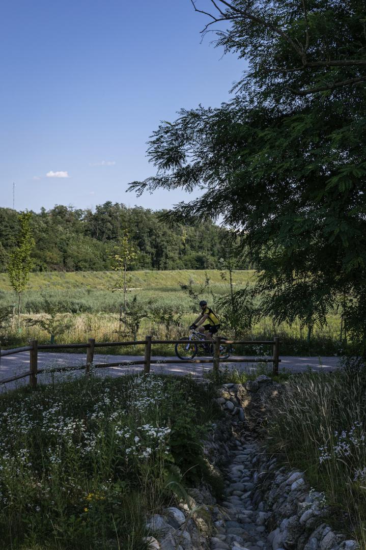
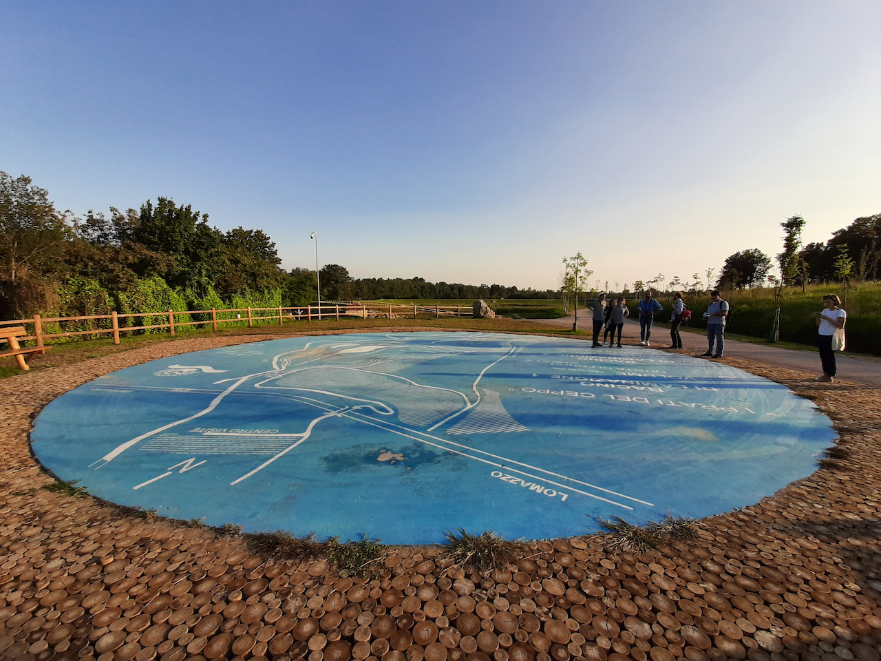
The project of the Lura River Retention Basins brought the river back to the people. It found a way to put the water cycle and the ecosystem on stage and raise the human respect of its functioning. A key-point of the Park is the round blue square which explains how the park works within the system of the entire river. It created a social space connected to the water with an high educational value. Furthermore, the design of the park created new interesting view points to discover the riverscape and there are various bird-watching stations, benches to enjoy the natural surrounding and the Biodiversity Centre close by. To keep the park as natural as it became, there is no car parking except for people with disabilities and the visitors shall all come by bicycle, feet or wheelchair as the entire infrastructure is barrier-free.
Thanks to the nature-based solutions implemented there are no bulky engineering works but the hydraulic functioning of flood protection basins is based on the principle of gravity.
The design of the park also creates a clear layout of connections and accessible spaces for easy orientation and pathfinding.
The Lura River Retentions Basins are a space where people can experience the dynamic of nature, it is changing all the time. During rain, when the water overflows from the riverbed to the retention basins, there are sirens warning to keep away from the basins borders. This alarm and the visible filled basin before the water is being given back to the soil make people aware of the frequence and strength of natural hazards and the climate challenges.
Key objectives for inclusion
The new riverbed represents a natural and neutral space in between three rural communes that equally feel ownership for the place. After decades it became a place where the neighbouring communities were able to have a shared place of encounter.
Native species have been used for reforestation works in order to increase the ecological value of the area. The vegetation had to be strongly recovered as the side was not very biodiverse. As several invasive species have threatened the local species, they were regulated in the course of a territorial intervention.
Due to its infrastructure, the park is reconnecting the rural areas with the urban centres around and offers a new abundance of local natural recreation. The locals gave there territory to safeguard the people living downstream in an act of solidarity and gained a beautiful natural space close by which is dedicated only to them.
Results in relation to category
The aim was to create an ideal habitat for the settlement of various animal species, such as the little bittern (Ixobrychus minutus) and the white heron (Ardea alba), which have appeared as a result of the intervention. The hydraulic functioning of the basins is based on the principle of gravity, a factor that has made it possible not to impact on land consumption by constructing particularly bulky engineering works such as pumping stations.
The great fruitive value of the area has leveraged the territorial character of the Lura Park, managed by a consortium of 12 municipalities, but it has been animated by a vision inspired by sustainability, which has privileged slow mobility as the only form of accessibility to the area and has promoted the divulgation of a green infrastructure such as this one through a square that illustrates the functioning of the basins, various birdwatching stations and a direct connection with the nearby Biodiversity Center, managed by the Lura Park. Paths and rest areas guarantee the usability by integrating it with the restored natural environment. Therefore we are very pleased to seehow the work as a whole has contributed to the achievement of five of the seventeen Goals for sustainable development provided by the Agenda 2030 of the United Nations. These include Goal 4.7, Goal 6.6, Goal 9.1, Goals 11.5 and 11.a and finally Goals 15.1, 15.3, 15,5 e 15,9.
A biodiversity centre is located inside the Lura Park, offering classes for students, sport events and courses and helps the visitors to strengthen their connection with their territory and their biodiversity values.
How Citizens benefit
The participatory and multi-sectoral approach has been a particularly important component in the multi-year process of this project: on the one hand it has represented an example of territorial solidarity, since the inhabitants of the municipalities involved have seen an infrastructure being built on their territory to serve communities downstream of the intervention site; on the other hand the consensus among institutions and residents has been motivated by the participatory process led by the local NGO KOINÉ.
The great benefit for the citizen was to receive an effective and easily usable hydraulic, ecological and social infrastructure on their territory. Even if the area previously was a rarely used monocultural agriculture, the inhabitants of the neighbouring communes were strongly against the intervention as the Water Shed Authority published their first ideas in 1995 in form of a 12 m high dam. Over time, there were 7 meetings organised by the Lura Park (consortium) and the local NGO KOINÉ to find the right way of project development and communication. Today, the park is being kindly regarded, it became more like a neighbourhood park than a tourist attraction where they organise sportive and cultural events which before was not able as the area consisted only of fields and field paths.
The involvement of local stakeholders has also led to the creation of virtuous dynamics at the management level: the farmers to whom the agricultural land has been expropriated are in fact actively involved in the maintenance of the park through the periodic removal of timber and cutting of brushwood.
Innovative character
The project is part of a supra-regional strategy of hydro-geological risk reduction. In fact, it is an application of the Lura Stream Subbasin Project promoted by the Interregional Agency for the Po River (AIPO) and the Lombardy Region, which co-financed the work. Almost all interventions in the park are nature based solutions. Unlike many other systems of flood protection, this project works without pumps but with gravity. Only the pavement of the park is made out of asphalt to be accessible for maintainance and care reasons and for the tractors. In exchange, the asphalt was colored in a bright color so that it heats up less under the sun.
Despite its recreation qualities, the decision of no dedicated parking on site was taken, to avoid it to become a theme park. Like this, the area became a biodiversity island which can stay quiet and only be reached by feed or with the bicycle. To avoid exclusion, there are some parking spaces solely for people with disabilities and the entire infrastructure is barrier-free.
This represents a new form of sustainable tourism, respecting the ecosystem and nature and give a voice to the non-human species.
The integration of the local NGO worked as a motivator for the agreement between institutions and residents and the participatory and multi-sectoral approach was a key component of the multi-year process of the project.