Along the rails around Etna
Basic information
Project Title
Full project title
Category
Project Description
Along the rails around Etna is a redevelopment project of an abandoned railway line as a sequence of public spaces and landscapes of slow travel, which interacts with the sicilian territorial context through the reuse of abandoned buildings and architecture, the valorization of the suburban agricultural landscape and local productivity and the creation of different spaces and activities along its line.
Geographical Scope
Project Region
Urban or rural issues
Physical or other transformations
EU Programme or fund
Which funds
Description of the project
Summary
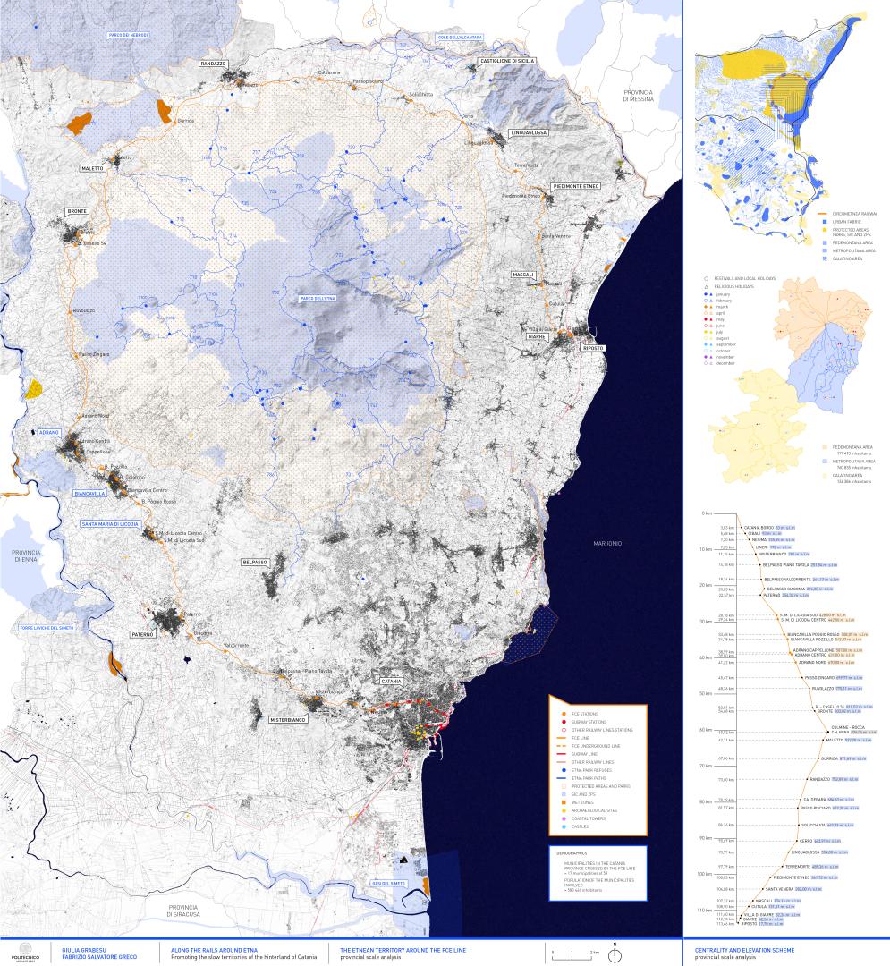
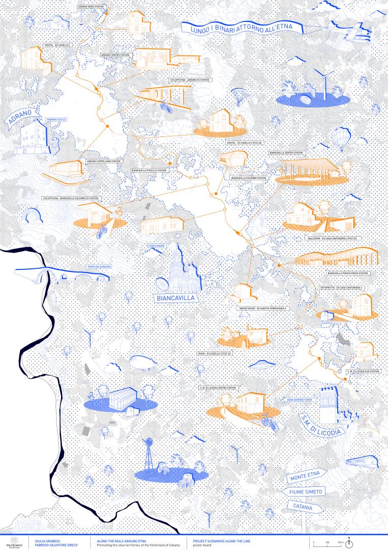
Centre of the most important activities in Sicily, the territory of Catania, which develops on the slopes of the highest volcano in Europe, has assumed in the past years a significant position in the tourist scene leaving the rest of the internal territory in the background. An opportunity of connection is given by the Ferrovia Circumetnea, which allows with its 113 km to cross the territory, starting from the sea level reaching the hinterland beyond the slopes of the "mountain". This service, strategic for the territory, is nowadays undervalued and badly structured.
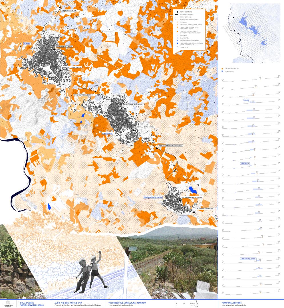
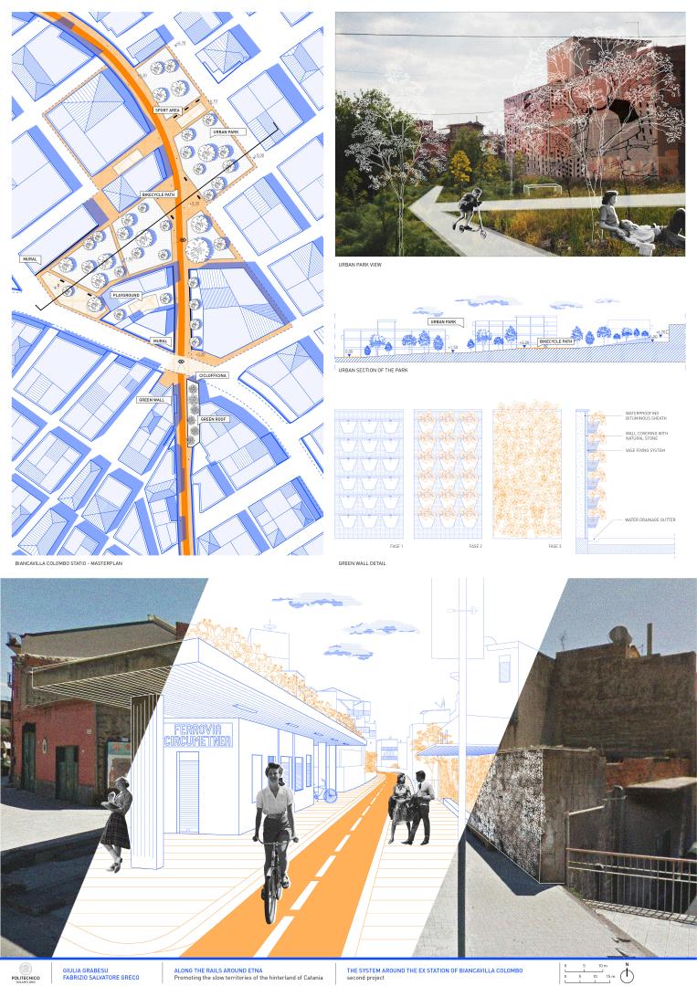
The recent works of undergrounding of a part of the line and the consequent redesign of some of the railway stations, although representing an opportunity, have left the situation unchanged, if not worsened. In particular in the towns of Adrano, Biancavilla and S.M. di Licodia, the railway lines that once crossed the cities, now underground, have left behind a void in the urban fabric, along with phenomena of abandonment and degradation.
The project starts from the analysis of the Sicilian territorial context, with the purpose of understanding the environment and the culture in which it is placed. The interscalar and multidisciplinary approach has allowed to read this complexity, opening new opportunities for the design of the line at urban level.
The objective is a redevelopment project of the abandoned railway line as a sequence of public spaces and slow landscapes, which interacts with the territory through the reuse of abandoned buildings and architecture, the valorization of the suburban agricultural landscape and local productivity and the creation of different spaces and activities along its line. These interventions are designed to encourage the development of new local economies and the offering of services to the community. Moreover, their integration within the railway system helps to promote the rediscovery of the hinterland and to offer a new point of view of Etna and its landscapes.
Key objectives for sustainability
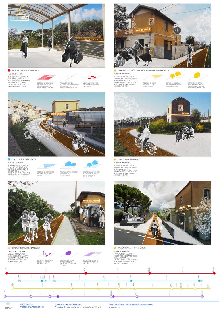
The aim of the project is the development of a light infrastructure that flows between the countryside and the city capable of enhancing the territories it crosses and the architecture, in use or in a state of abandonment, that faces the line. An operation of reconstruction of the invisible link between landscape, architecture and history is carried out, promoting the regeneration of resources no longer used. In particular, the latter have been first classified and then subjected to operations of different nature - including maintenance, recovery and new construction - starting from an articulation of the program of public and private uses and functions that will be hosted.
The project is therefore proposed as an open system that through a series of actions is able to stimulate and reactivate the different economies in the area, from small local neighborhoods to public ones involving the entire municipality. The aim is to create a varied range of services, through a series of minimal interventions - such as the functional optimization of the spaces in operating stations – and punctual and low-cost actions, like the addition of equipment and devices including lighting systems, seating and signage. There are also planned measures focused on the redevelopment of abandoned architecture and their inclusion in a system of 24-hour services for the benefit of citizens.
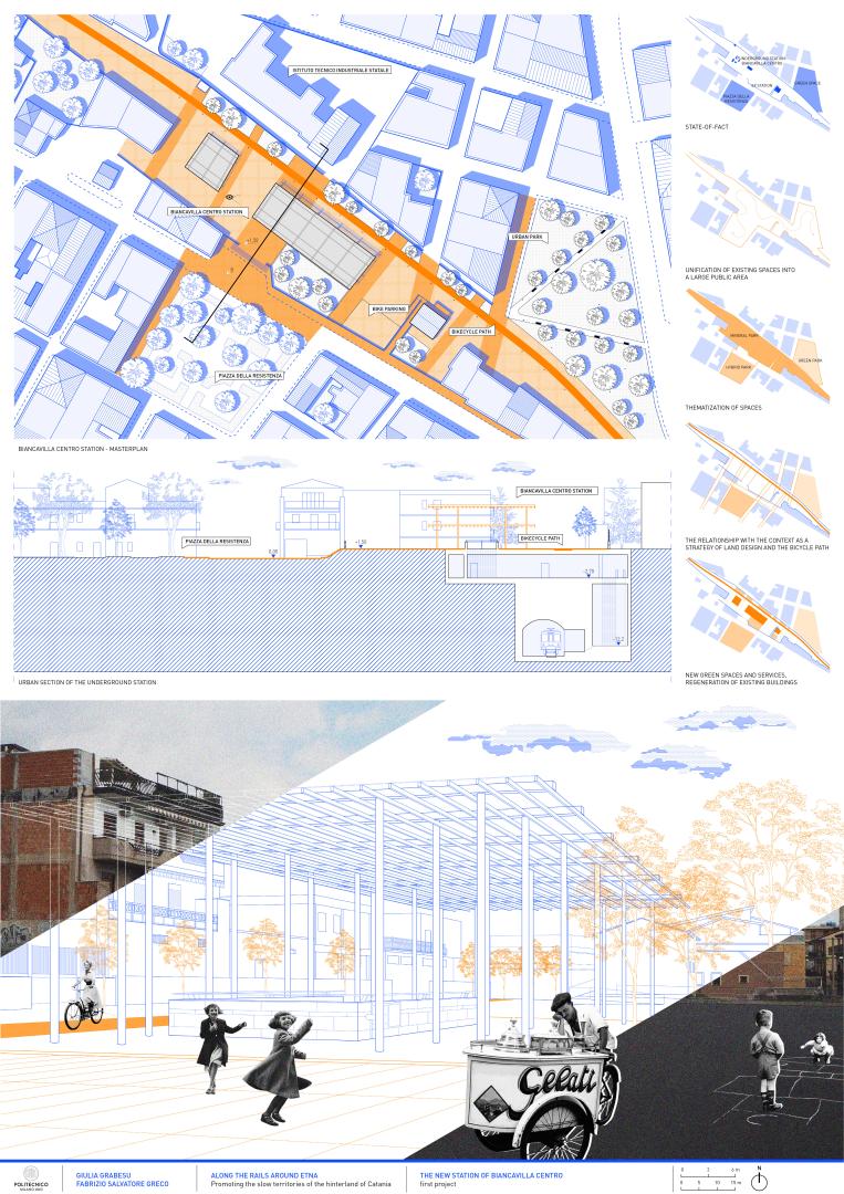
The renovation of the former railway line as a cycle-pedestrian path and of the sediment as a linear park is therefore a fundamental operation for the reconstruction of the urban fabric, without affecting the landscape with invasive actions on the territory and landscapes that the line crosses.
Key objectives for aesthetics and quality
The strategy is developed in the definition of a line completely open to transversality with the other existing paths and in the creation of a line able to connect and revitalize the whole rural and urban territory that it crosses. This line, by intersecting spots and stations that are currently working of the railway system and the Circumetnea bus system, gives the citizen or tourist the opportunity to travel and visit the realities of the hinterland, starting from the slopes of Etna up to Catania, crossing stretches of citrus groves, vineyards and olive groves and passing through many areas of DOP products.
The cycle-pedestrian line is therefore what is "between", a space that materializes and connects different realities and three different cities, linking them in the daily urban life and crossing at the same time the agricultural and productive realities of the countryside. This system is thus designed to support different types of flows, starting from the daily flow of citizens to the fast flow of athletes, passing through the suspended flow of travelers and, occasionally, the frenetic flow of tourists.
The recovery of the old railway tracks allows the reinterpretation of the territory in a new key, rediscovering ancient flavors, culinary traditions and new panoramic points of the territory. Moreover, thanks to their linearity you have the opportunity to rebuild one of the most important codes for reading the territory in the contemporary world: the path as a crossing. This, as well as the place where an observer moves normally and occasionally, is the reconstruction of an image and a scenario on which to build a recovery project. The aim is to stitch spaces, landscapes and territories, providing ideas and valuable solutions for the activation of territorial policies aimed at the development, enhancement and promotion of the identities of places.
Key objectives for inclusion
A linear system of requalified open spaces along the cycle-pedestrian path located on the ex railway line - made accessible by removing architectural barriers, adding ramps and levelling the ground - is combined with a wider system of requalified architecture, equipment and devices. This supports the creation of a new network of essential short-range facilities, focusing in particular on the proximity of services and the accessibility of the line.
The project envisions new job opportunities and the creation of potential spaces for not only production and processing functions, such as craft centers, spaces for selling local products and temporary residences, but also essential 24-hour services such as shipping and pickup centers or water houses. The project therefore provides for minimal and punctual interventions and explores new ways of redeveloping the abandoned railway architectural heritage.
Citizens are also invited to actively participate in the realization of the project through collaborations with local artists and professionals in the creation of installations, temporary works of art, lighting systems and informal signage, to be placed occasionally along the route of the line offering the user new ways to observe the territory and its surroundings. In this way we try to give a deeper awareness of the environment in which we live, by giving back value to places and spaces and by reopening a debate on issues now forgotten. The focus shifts to the material and immaterial heritage that the line embraces along its way, offering insights while providing the comfort given by these physical equipment and visual devices.
Physical or other transformations
Innovative character
The development of a project like the one that this thesis suggests within the Etnean context, in the municipalities of Adrano, Biancavilla and S.M. di Licodia, means operating on several levels, simultaneously giving this system of city-landscape a variety of roles and functions through the reuse of an existing track, without imposing complex projects of intervention but experimenting step by step new and different ways of transformation, management and preservation of spaces with discretion and economy "starting from what is there" and enhancing what the territory provides.
Within a complex context such as this it was therefore essential to implement a process of reinterpretation of the territory, considering the geographical and morphological aspects, lifestyles and ways of appropriation of space, existing economies and those realistically activatable.
Based on these considerations, the idea of the project takes shape in small-medium sized towns in the Etnean hinterland, through a linear sequence of abandoned places to be redeveloped and reactivated. The design of the "exceptional" space of the abandoned railway, which links a series of towns on the slopes of Etna, becomes an incredible opportunity to respond to the increasingly urgent need to think about sustainable mobility, urban regeneration, development (also economic) of the productive agricultural landscape in the inner local territories, as well as the possibility of intercepting the European funds available for the implementation of these objectives.