Evaille - Niort Living Thresholds
Basic information
Project Title
Full project title
Category
Project Description
The proposal formulates a design narrative where water is a key element for innovative scenarios that engage with our changing climate. As riverine and humid environments do not consist of permanent and fixed habitats to be defended at all costs, the project envisions new type of inhabitable landscape that accepts water fluctuations in lowlands and make this natural phenomenon a pretext to rethink how the southwest fringe of Niort relates with its outer landscape.
Geographical Scope
Project Region
Urban or rural issues
Physical or other transformations
EU Programme or fund
Which funds
Description of the project
Summary
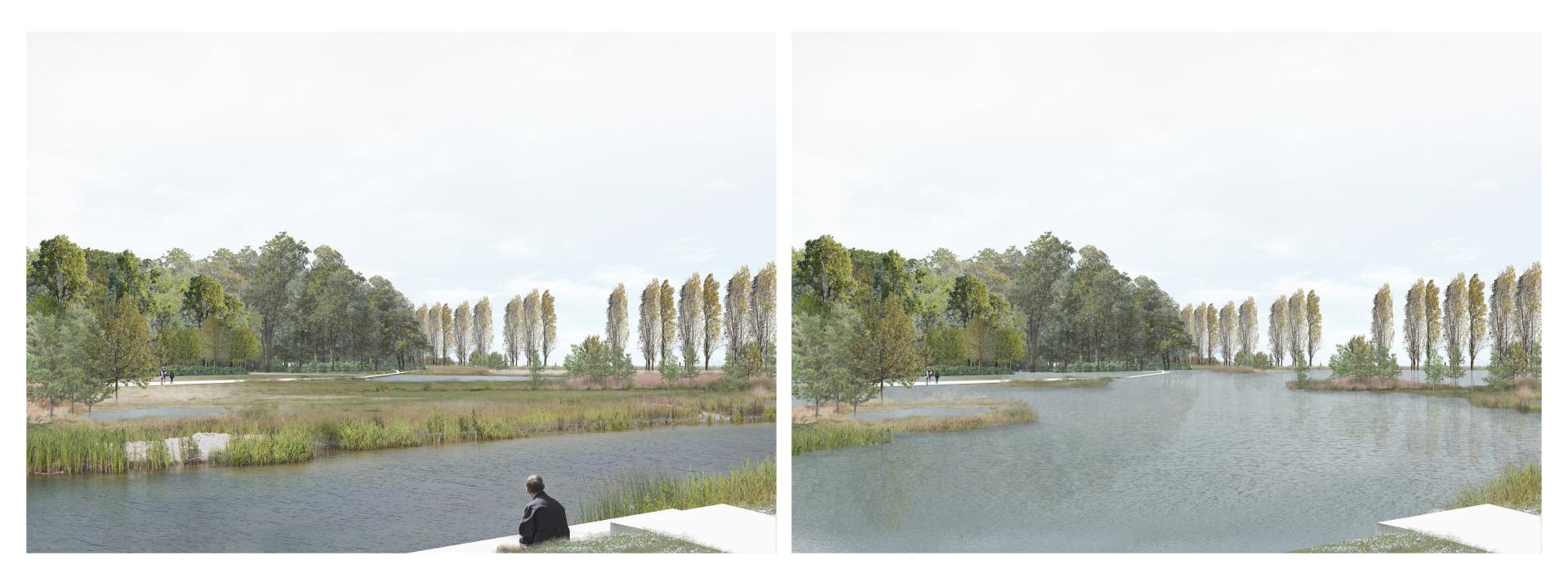
Évaille is a term used in the Poitevin Marshes - western France - to describe the water level-rise during winter. Unlike damaging floods, évaille is not seen as a disaster: water just reclaims the place that was its own before man built the marshes’ network of canals.
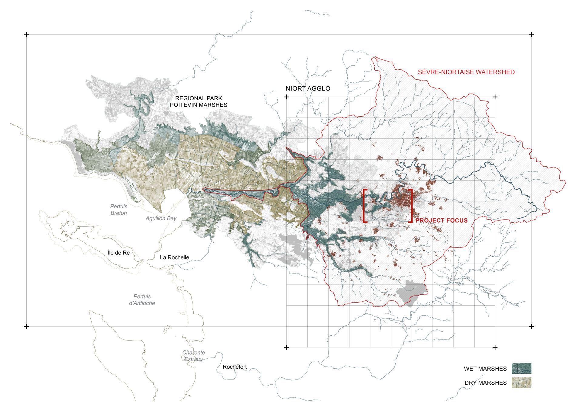
This natural yet cultural feature inspires the project; it suggests a multi-scalar engagement with the territory, drawing on the potential uses of water as a gradual means of regenerating milieus. Water is the key element to reconnect the city of Niort with the Poitevin Marshes, a natural parc of about 80.000 ha. Due to sea-level rise, this fragile landscape risks a deep alteration, with consequences also for Niort.
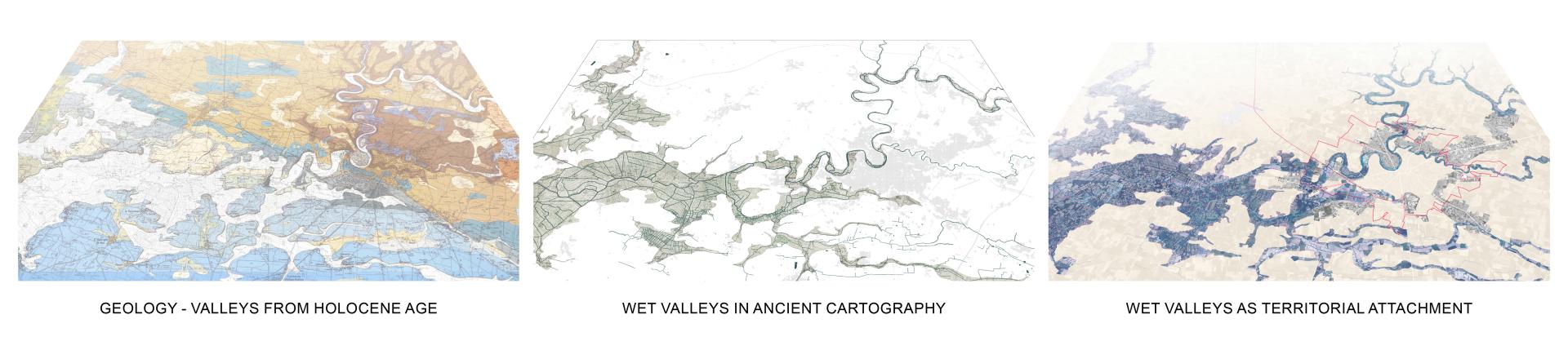
Watershed-scale and geological analysis show how the wet marshes can be seen as a form of territorial attachment. The valleys – made of Holocene sedimentary infill – become the southern structural limit of the city and the space that will handle future water fluctuations without compromising the urban activity.
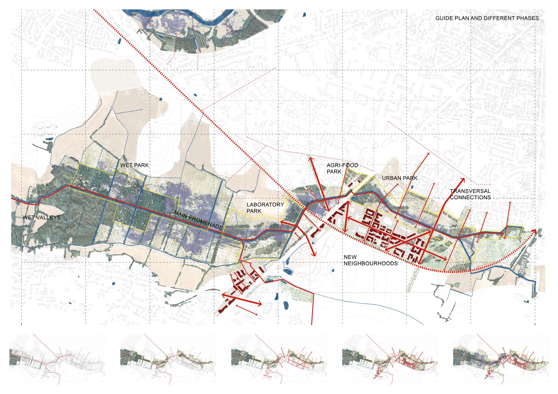
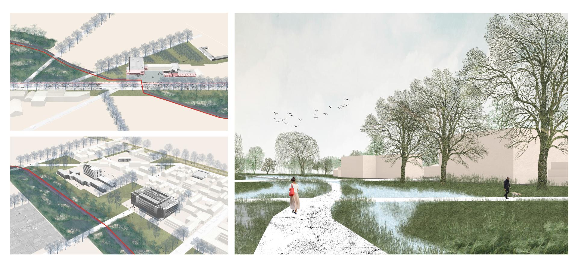
A new type of inhabitable landscape in this interface is, therefore, proposed. Along the existing canal, built spaces in low flood-prone position are demineralized to increase water permeability and green infiltration into the urbanized areas. A park-chain is suggested to create outdoor quality spaces at the core of new and existing neighbourhoods. Lastly, a greenway is obtained from an abandoned track, constituting the backbone for future urban densification. If implemented, these interventions would radically transform the southern city entrance with an interface that promotes inclusivity between human and nonhuman flows.
Based on clear climate trends yet with crucial uncertainties towards the end of the century, the proposal creates a “scape” that emphasizes water fluctuation rather than neutralizing its effects. The new waterscapes reposition natural processes within the living environment, making climate change and the wet landscape a daily life tangible feature.
Key objectives for sustainability
The project highlights the importance of committing to a carbon-neutral approach by 2050, in line with EU climate guidelines and the French Climate Plan (FCP).
Firstly, the seasonal rewetting of the valleys in the southern fringe of Niort – lowlands rich of organic matter - is proposed as one of the major initiatives to radically reduce CO2 emissions, improving the capture and storage of carbon in the ground.
Secondly, a series of afforestation patches are suggested to increase CO2 storage capacity, to fight against the rising of the water table and to protect underground aquifers and drinking water from anthropic pollution. Beside their environmental effect, they could be used as biomass resource and increase the quality of outdoor spaces. Along the main canal, they create a park-chain that penetrates the southern urban boundary, from the valleys into the residential periphery of the city.
Thirdly, the greenway obtained from the reused abandoned track follows the FCP guideline to develop clean mobility that is accessible to everyone in proximity to residential neighbourhoods.
Circularity becomes a central figure of the suggested concept. It enhances environmental fluctuations instead of working against them, using the metabolic processes of the region. For instance, the natural phenomena called évaille is a remarkable example of territorial metabolism; water, loaded with alluvium, is useful for soil fertility, boosting the productivity of the land and therefore the local rural economies, largely based on agriculture and livestock farming. The lowlands rewetted during colder months could become fertile areas where to promote small-scale agriculture for the self-sufficiency of local communities in spring and summer.
This vision can be exemplary because uses this test-site to show how EU climate objectives could be spatially implemented, in a proposal that combines practical solutions for climate adaptation with local cultures and people wellbeing.
Key objectives for aesthetics and quality
The experience of the urban fringe is enriched structuring a spatial framework that can deploy new synergies between the city and its landscape. The goal is to gradually give shape to a space where the hybridization of natural environments, inhabited milieus and local culture and economy can take place.
In contrast to the highly transformable space of the wet valleys, three stable elements are re-defined: the park-chain, the greenway, and the urban alley.
The park-chain is the place for conservation, recreation, and pedagogy and breaks down into different atmospheres. In the Wet Park, afforestation patches welcome water fluctuations in winter and pastures during dryer months. The Laboratory Park is a test site with pedagogic purpose to show how the landscape is adapting to climate change. The Agri-Food Park is a public space that combines vegetable gardens, collective orchards, and farm-gate-sales for local food producers. Lastly, the Urban Park is created in proximity of new and old neighbourhoods.
The greenway is obtained transforming the old “voie ferrée de la Possonnière”. It could boost local slow-mobility and the slow-agrotourism interest in the region, potentially connecting Niort to Cholet (Maine-et-Loire).
The urban alley (Rue de La Rochelle) is transformed only in those strategic points where it meets the previous two components (i.e park chain and greenway). Specific crossing spots and a closer relation with the valleys’ wet environment could radically transform the entrance to the city and the perception of the surrounding landscape.
The overall concept brings climate change and natural dynamics in the foreground. A thorough understanding of the landscape gives the knowledge to transform the urban periphery. The project is exemplary in the way it revaluates the territorial geography and the valleys’ natural fluctuations. Through the definition of these public spaces, it brings the aesthetic and physical experience of the outer landscape into thei
Key objectives for inclusion
The project tackles inclusivity from a holistic perspective. In the era of ecological transition, plans for productive and liveable cities need to be directly responsible to the inclusion of the different human and nonhuman actors. To face climate change in such a fragile shifting territory, the proposal puts on the same level human and nonhuman dynamics, namely the interactions between anthropic activities and needs with the ones of other living forms.
The uncertainty of natural evolutions is accepted inside the planned transformations. From a design perspective, the concept gives to water and the scale of hydraulic geography a prominent role. As emblematic figure of this region and of the Poitevin Marshes, water is here conceived as a co-designer of the proposal. Instead of taming water, the suggested design accepts its dynamic character and enhances it. The rising and falling of water levels during the different seasons will contribute to shape the landscape and to constantly change its perception.
Active participation of local communities to on-site visits is here considered a fundamental aspect of the proposal to enhance the social and pedagogic value of the landscape. Together with workshops, they aim to stimulate observation and imagination, increasing people awareness on climate change and its effects on their daily life.
These shared and inclusive goals could prepare the ground for a collective definition of new bio-geopolitical objectives able to consider human and nonhuman interests in the form of spatial transformation processes and land-use.
Physical or other transformations
Innovative character
The project highlights the need to create a shared platform of practical and theoretical experimentation around natural cycles, (bio-geo) politics, and people. These are three crucial actors in activating and regenerating inhabited milieus. Such platform aims to bring together local communities, policy makers and stakeholders to define together a geo-logic vision respectful of the land and useful to stimulate urgent discussions about the future of this territory.
However, environmental sustainability, aesthetics and inclusivity are fundamental issues that can’t be tackled only from a planning perspective. The proposal therefore emphasizes the need for spatial investigations of different land-uses to find new synergies able to negotiate the different ambitions on how to best use our shared landscape in times of climate change. Nowadays, this last aspect is still largely unexplored in the landscape architecture discipline.
As stated in the French Climate Plan, the design of future solutions should come together with research. On a theoretical level, this platform aims to favour cross-disciplinary research and knowledge exchange, bringing together different disciplines such as architecture, sociology, history and earth sciences like hydrology, biology, geology, etc. Cross-disciplinarity and a research-through-design constitute the base for the development of innovative practices. This idea could be implemented on site with the creation of a landscape observatory able to gather different expertise and scientific knowledge. The formulation of scenarios will advance proposals that can deploy new synergies between the unfolded potentials of the milieu where the transformation processes become the drivers of gradual and economically sustainable territorial change.