Reading the heritagescape
Basic information
Project Title
Full project title
Category
Project Description
Local communities and agents are offered an app to understand, enhance, manage, and promote their landscape through the local heritage. The design of the app is based on digital mapping, narrative construction, network analysis and route design. The aim of the app is to offer a pleasant and enjoyable experience that causes greater awareness, knowledge and pride in the rich local heritage pieces and how they contribute to the character, uniqueness, identity and culture of a region.
Geographical Scope
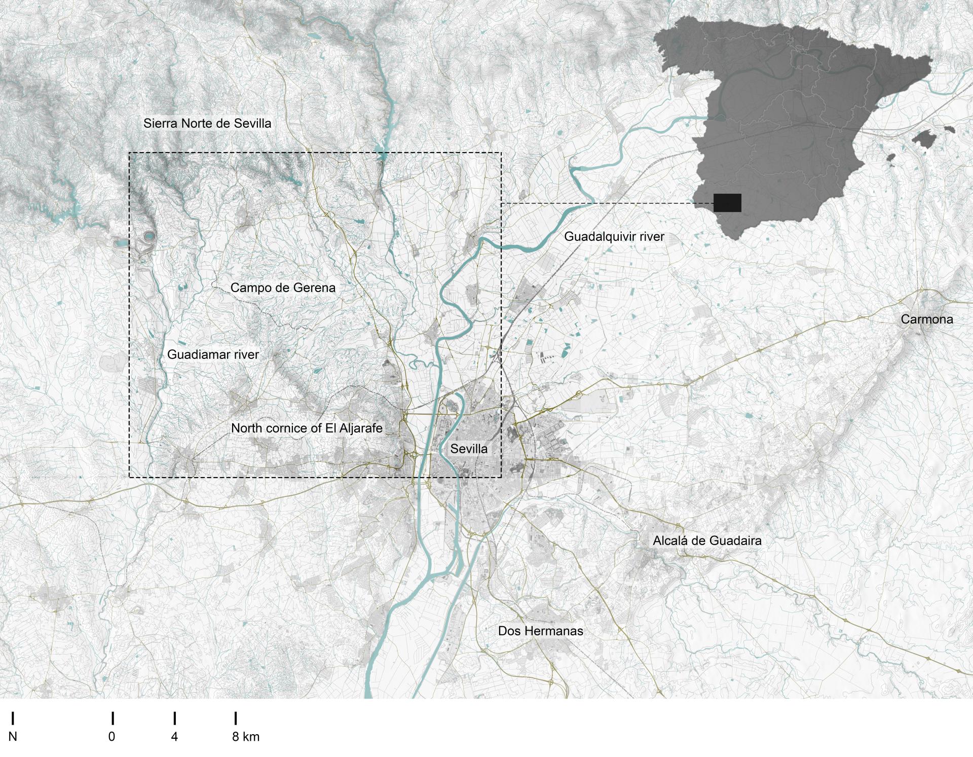
Project Region
Urban or rural issues
Physical or other transformations
EU Programme or fund
Which funds
Description of the project
Summary
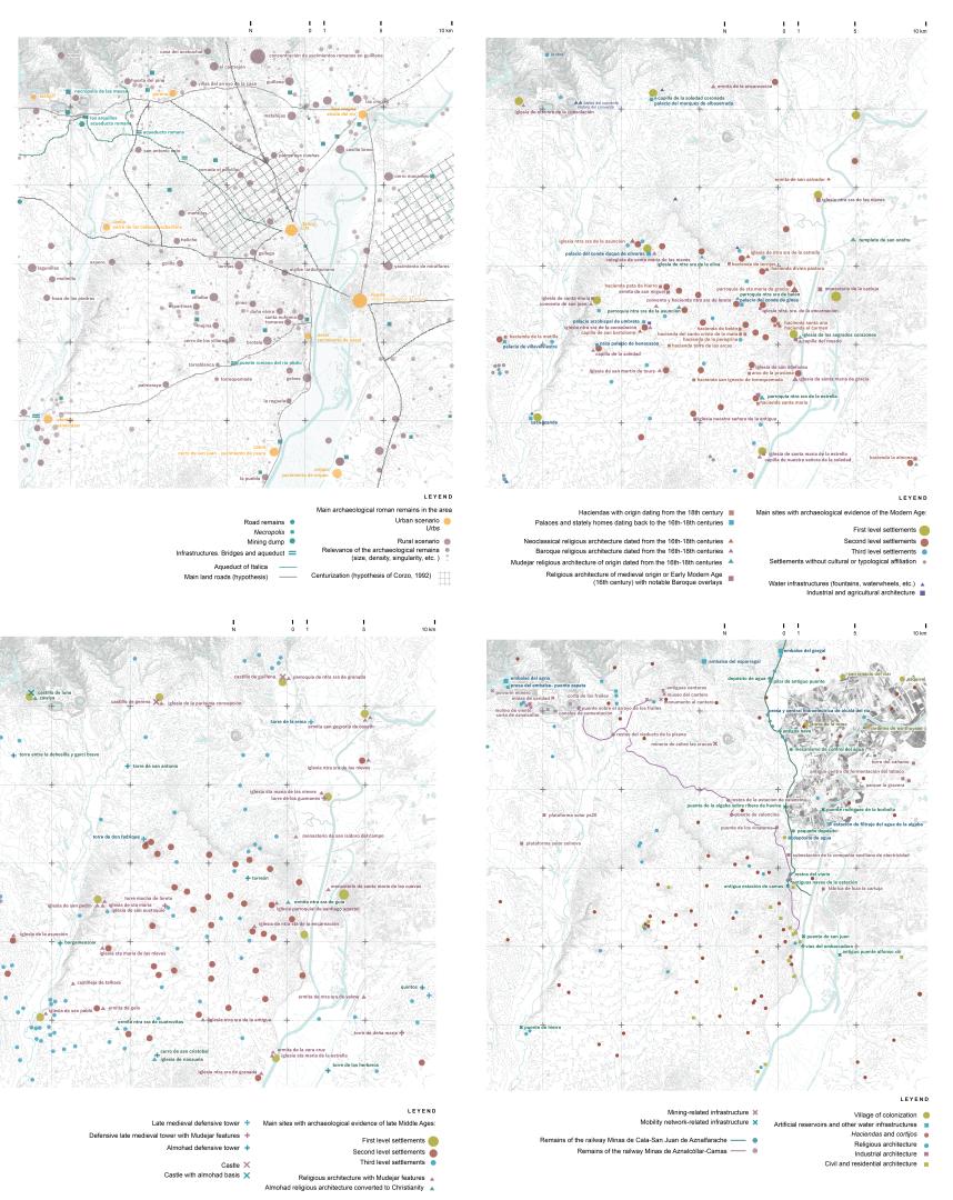
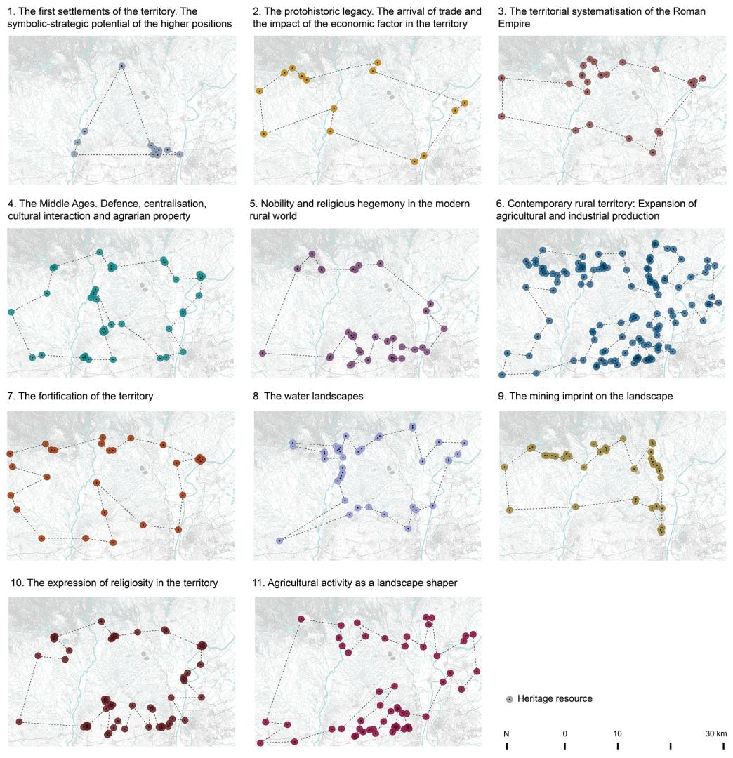
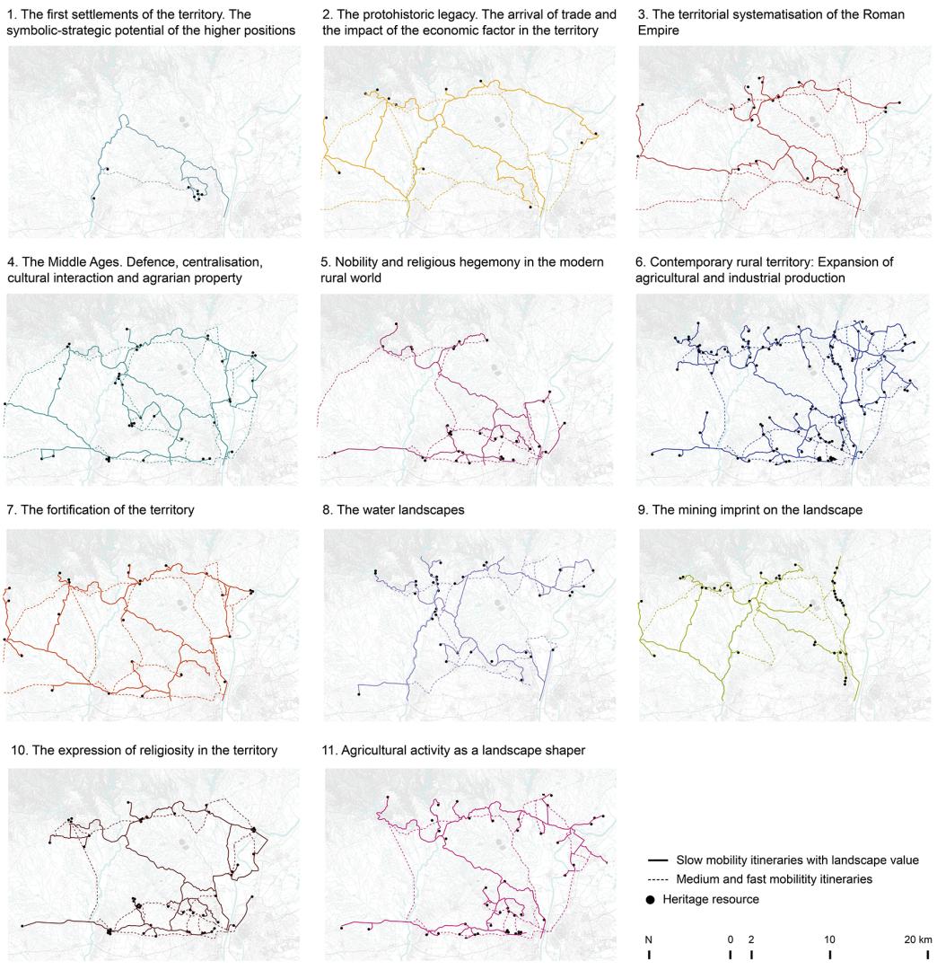
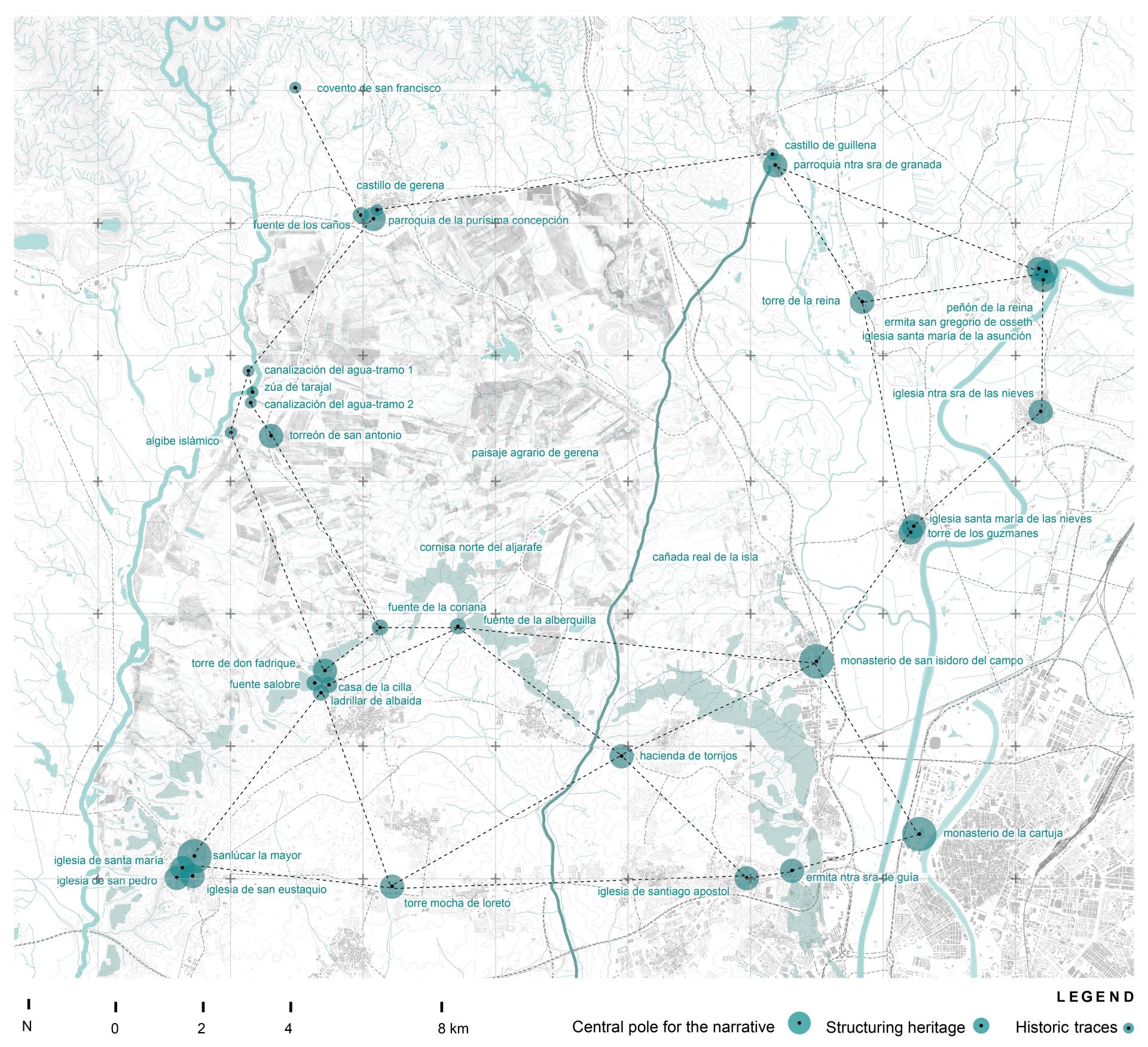
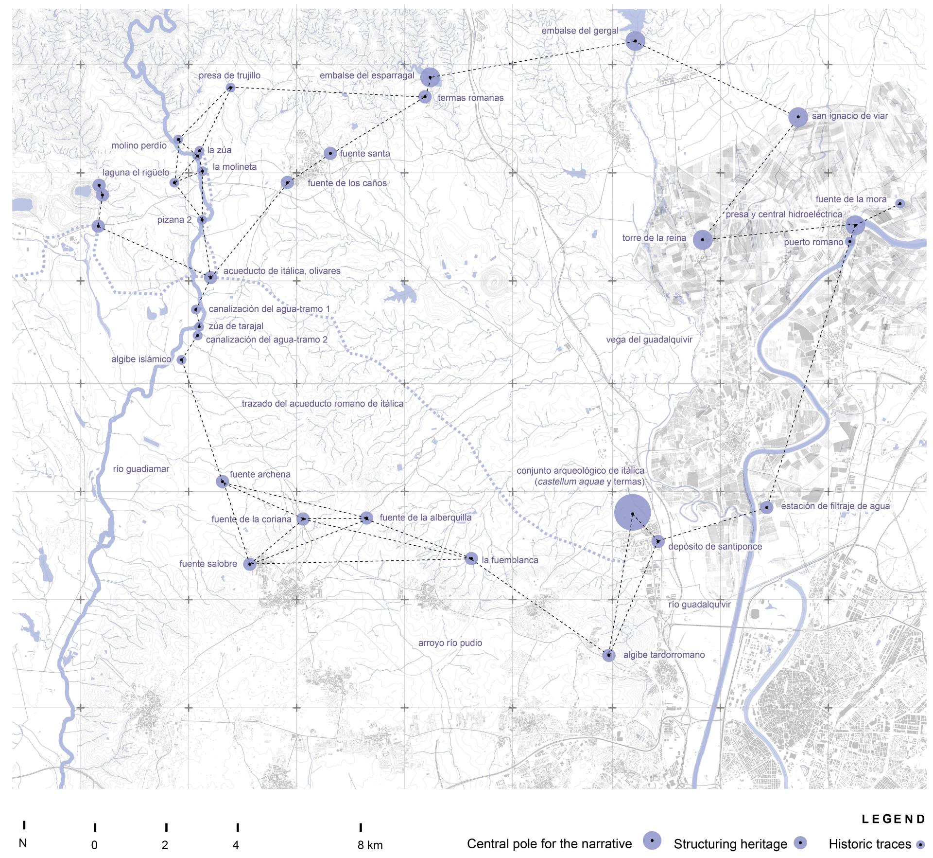
The extensive mesh of identity manifestations that define, in each place, its characteristic landscape is made up of singular heritage pieces of special historical and artistic value, but also by an extensive set of historical permanences scattered throughout the territory that, although they do not have the singularity of the most outstanding pieces, express in an integrated way the particularity of a territory and its history. All these local heritage traces cannot be covered by the heritage protection scheme because they would collapse a system that is focused on safeguarding the singular, but they could be addressed within a landscape-based strategy. Promoting strategies for recognizing and valuing the heritage structure that underlies any landscape, beyond its most singular components, is vital because it ensures the permanence of the differentiating features of the landscapes and thus contributes to maintaining diversity, identity, uniqueness, cultural richness, sense of place and sense of belonging. Under this premise, an app design is proposed. It aims is to offer an enjoyable experience that allows communities to discover their local heritage and the stories associated with it. The app has mainly three functions: to recognize and locate the complex mesh of local heritage pieces of a landscape (1); to organize the local heritage pieces on the basis of thematic landscape networks. Each network tells a particular story about the landscape that can be read or listened directly in the app (2); to ‘spatialize’ the stories: the app will connect the heritage pieces of each network-story through the existing slow mobility structure (3). In this way, different thematic cultural routes are created so that the local population can access on foot or by bicycle the heritage. It also offers local administrations a resource to promote their heritage and landscape through experiences that combine an open-air recreational activity with cultural leisure.
Key objectives for sustainability
The proposed app offers the citizenship the possibility to discover local heritage pieces and learn different stories associated with them. In this way, people can better understand the cultural value of the places they inhabit and reinforce feelings of belonging and pride. Besides, the app will allow citizens to interact with spatial data for the creation of cultural itineraries that propose new dynamics of slow, climate-neutral mobility. Following the DNSH principles, the use of the application will contribute substantially to the mitigation of climate change, in accordance with Art. 10 of the Taxonomy Regulation: it promotes the increase of clean or climate-neutral mobility. In relation to adaptation to climate change, the use of the application will generate minimal energy consumption. The project has no or negligible foreseeable impact on the sustainable use and protection of water and marine resources, since it is alien to said resources. In relation to the circular economy, the app is a service whose implementation, being digital, has imperceptible effects on waste management. The decrease in the use of motor vehicles through the promotion of slow mobility dynamics will produce a reduction in pollution to the environment. According to the protection and restoration of biodiversity and ecosystems, the project has no or negligible foreseeable impact on the related environmental objective. It is considered that, although the application can generate a greater presence of people in rural areas, its local dimension in any case foresees low levels of occupation that will also have a positive impact on the conservation of cultural heritage. In general, the app is a resource with very low environmental impact that also favors positive dynamics (slow mobility, outdoor activities, cultural leisure). Therefore, it is considered to a large extent beneficial for the environment and the human beings.
Key objectives for aesthetics and quality
The app is meant to present to citizens a digital striking environment where they can consult data and generate maps. The app is functional because it allows knowing the location of the local heritage elements of a place and their basic information, including a description and photographs. It also allows to consult different stories associated with the heritage pieces and to see how this pieces can be classified and organized through those stories. Finally, it is possible to discover different cultural routes to visit the heritage resources. All this digital documentation and mapping exercise is enhancing the value of the place, presenting it as an interesting cultural landscape, full of stories to discover and historical pieces to visit. The graphic expression of the app and its maps is fundamental to reinforce this message. Therefore, the app proposes an experience but also presents a visual image. It is a digital tool that requires functionality as well as iconicity, clarity, beauty and design. For this reason, the key objective of the app in relation to aesthetics lies in the graphic design of the app and its maps. Therefore, it is a project that seeks to establish serious commitments with the fields of graphic and digital design. Both fields are producing important and very interesting advances in the arts, aesthetics and culture. It is necessary to understand that the application is not intended to be just a service, but a product in itself. A product with a clear aesthetic dimension that should make citizens proud. And it is this pride that must be channeled into a greater respect for the landscape and into more intense feelings of identity and attachment to the place.
Key objectives for inclusion
The app will be publicly available on the web once it is final and can be used by any citizen. It is not intended for a specialized user or a specific audience. Its potential users are expected to be the inhabitants of the area, who are offered a resource that enriches their chances of taking advantage of free time in the immediate environment, which implies direct social benefits. The proposal is inclusive because it is designed to adapt to different users. The stories are offered in a children's and adult version. There will also be the possibility of downloading the cartographies so that they can be printed by the population less familiar with digital technologies. And, in addition, the app will seek citizen commitment and participation by offering itself as an open tool. It will include the possibility for the citizens themselves to register new pieces of heritage, or new information on those already registered, such as photographs. It will also allow for suggestions and comments to be added to the landscape stories, thus helping the stories combine historical information with local knowledge. The app is an environment in continuous construction, a citizen resource so that everyone can build together the history of their landscape. Every approximation, approach, point of view, is welcomed. The sense of belonging and pride is intensified by making available to the population a resource that values and beautifully displays the place where they live. But the sense of community is also stronger, since at all times it is a resource to which everyone can contribute.
Physical or other transformations
Innovative character
Throughout its entire life cycle, including its execution and the impact of its results, the project does not cause significant harm to the environment. The app is likely to be used as a basis for the enhancement of heritage and its territory of belonging. The citizen participation mechanisms of the application are a source of knowledge from which to support the design of viable and desirable alternatives for experiencing the landscape, in accordance with the objectives of the 2030 Agenda. This environmental commitment is intrinsic to the application, as is its aesthetic and social dimension. It is a balanced idea regarding this triple dimension, conceived from a serious commitment for each of the three spheres. The application needs to be beautiful, eye-catching and aesthetically suggestive to capture the attention of the local population. Citizen attention and commitment are necessary so that the application can really favor positive sustainable dynamics in the territory. It is a chain effect where no dimension is more necessary than the other two.