Contemporary Garden City
Basic information
Project Title
Contemporary Garden City
Full project title
Rethinking the garden city of yesterday with the public spaces of today
Category
Regaining a sense of belonging
Project Description
Bon air neighbourhood is one of many garden cities in Brussels. Its specificity is that it is today still at the edge of the city and is surrounded by the countryside of Flanders. Its fabric feels like a small village. Our mission was to redesign all of the public spaces of the neighbourhood, that had been designed a hundred years ago, to adapt them to todays urban conditions.
Geographical Scope
Local
Project Region
Bon Air, Anderlecht, Belgium, Belgium
Urban or rural issues
Mainly urban
Physical or other transformations
It refers to a physical transformation of the built environment (hard investment)
EU Programme or fund
No
Description of the project
Summary
Bon air neighbourhood is one of many garden cities in Brussels. Its specificity is that it is today still at the edge of the city and is surrounded by the countryside of Flanders. Its fabric feels like a small village.
Our mission was to redesign all of the public spaces of the neighbourhood, that had been designed a hundred years ago, to adapt them to todays urban conditions.
Our mission was to redesign all of the public spaces of the neighbourhood, that had been designed a hundred years ago, to adapt them to todays urban conditions.
Key objectives for sustainability
The Bon Air neighborhood is one of the many garden cities in Brussels. Its uniqueness lies in its location at the edge of the city, surrounded by the countryside of Flanders. The fabric of the neighborhood imparts a small village ambiance.
Our mission was to redesign all the public spaces in the neighborhood, which were originally designed a hundred years ago, to adapt them to today's urban conditions.
Our mission was to redesign all the public spaces in the neighborhood, which were originally designed a hundred years ago, to adapt them to today's urban conditions.
Key objectives for aesthetics and quality
The first phase of our task consists of a pre-project phase, with a comprehensive study on the reorganization of mobility and parking throughout the garden city. This aims to permanently eliminate transit traffic and address unauthorized parking in the area.
The new traffic scheme proposes three distinct loops with the goal of definitively eliminating transit traffic, streamlining the school scheme, and the school bus routes, all while securing the entire neighborhood. It will also free up pedestrian public spaces by removing overly large road intersections and create space for pedestrian-friendly modes of transport in the streets.
On the other hand, a master plan for the entire neighborhood defines six project categories based on high-potential zones highlighted in the site analysis, including:
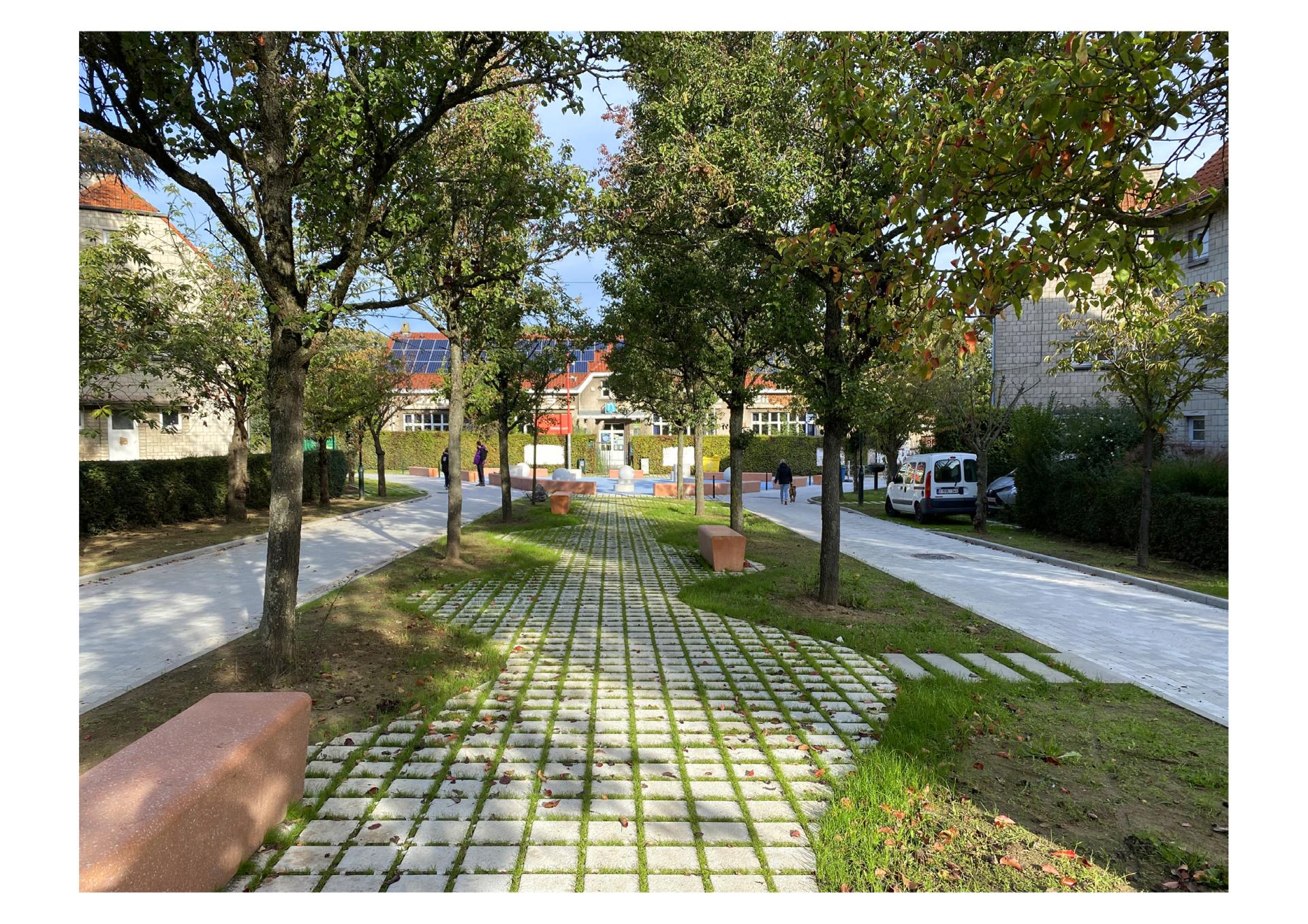
The definition of themed pedestrian public spaces, replacing existing large road intersections with landscaped areas.
Redefining street profiles by implementing one-way traffic, allowing for designated parking spaces, eliminating unauthorized parking, and creating planted and permeable zones.
Working on the "entry points" to the garden city from Avenue d’Itterbeek, serving as distinctive signage welcoming entry into a unique neighborhood.
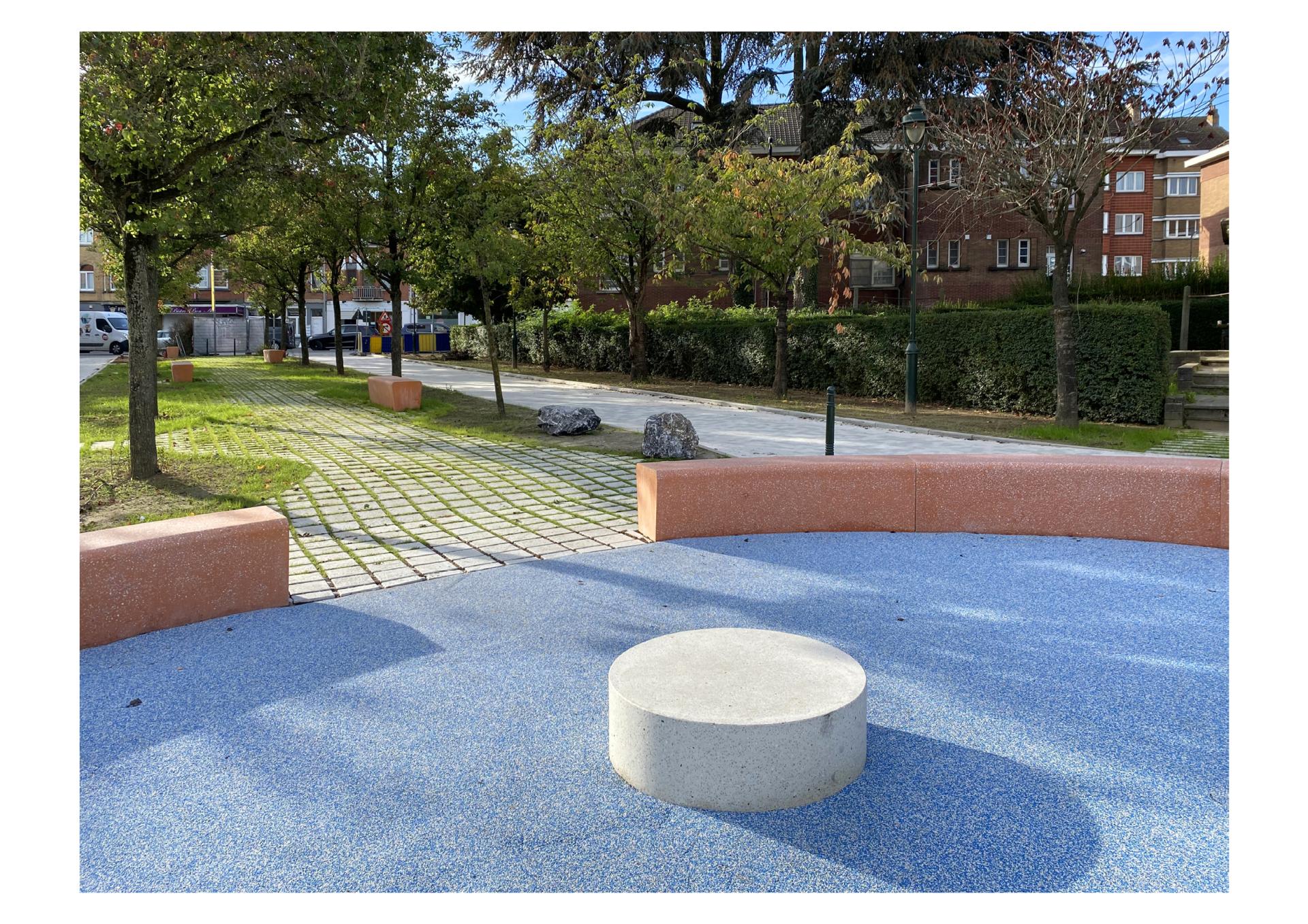
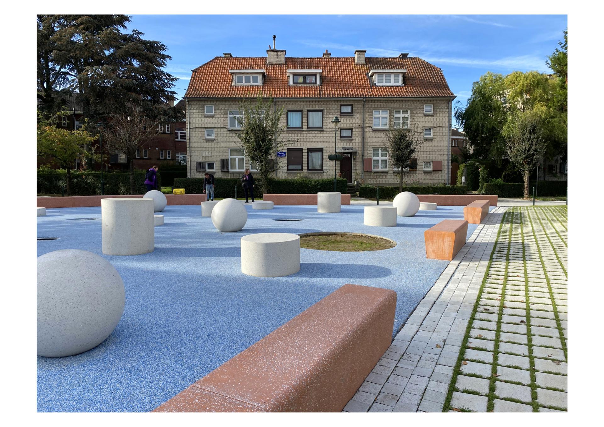
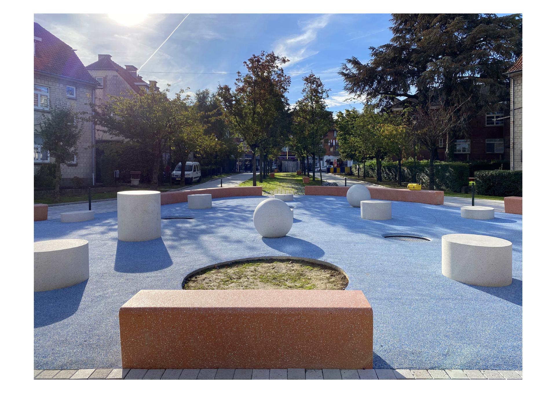
Revamping Séverine Square and its surroundings as a significantly expanded area dedicated to outdoor sports, directly linked to the school renovation/extension project and the demolition/reconstruction of the gymnasium on the square.
Redefining currently abandoned public block cores as ecological reserve areas densely planted with flora and fauna unique to each.
Reprogramming the fringe of vacant spaces to the North up to the border with the Flemish Region and to the East up to the Ring Road boundary.
The new traffic scheme proposes three distinct loops with the goal of definitively eliminating transit traffic, streamlining the school scheme, and the school bus routes, all while securing the entire neighborhood. It will also free up pedestrian public spaces by removing overly large road intersections and create space for pedestrian-friendly modes of transport in the streets.
On the other hand, a master plan for the entire neighborhood defines six project categories based on high-potential zones highlighted in the site analysis, including:
The definition of themed pedestrian public spaces, replacing existing large road intersections with landscaped areas.
Redefining street profiles by implementing one-way traffic, allowing for designated parking spaces, eliminating unauthorized parking, and creating planted and permeable zones.
Working on the "entry points" to the garden city from Avenue d’Itterbeek, serving as distinctive signage welcoming entry into a unique neighborhood.
Revamping Séverine Square and its surroundings as a significantly expanded area dedicated to outdoor sports, directly linked to the school renovation/extension project and the demolition/reconstruction of the gymnasium on the square.
Redefining currently abandoned public block cores as ecological reserve areas densely planted with flora and fauna unique to each.
Reprogramming the fringe of vacant spaces to the North up to the border with the Flemish Region and to the East up to the Ring Road boundary.
Key objectives for inclusion
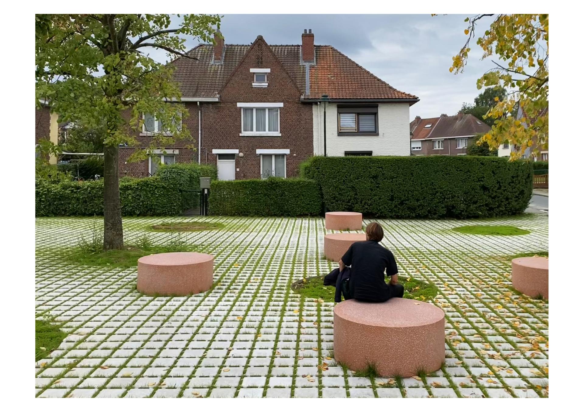
The urban planning permit, tender dossier, and construction phases develop the concrete project for the development of 6 new public spaces. The redefinition of mobility and traffic zones transforms residual spaces into 6 new fully-fledged urban squares. Urban redevelopment thus tackles the challenge of reshaping the hierarchy between car-dedicated space and pedestrian space in public areas.
The road textures are standardized across all squares, roads are raised to sidewalk level and delicately delineated. Sidewalks are expanded, further reducing the proportion of space allocated to car use. As a result, 2000m2 of ground area is reclaimed for pedestrians. Drivers navigate on a "pedestrian floor" and adjust their driving and speed accordingly.
Themed squares act as focal points for activities and leisure, featuring dense vegetation and urban furniture tailored to meet the expectations of each user. The projects prioritize strong rainwater infiltration to minimize contributions to the sewer system by proposing numerous densely planted areas in public spaces. In this regard, over 1000m2 of open ground and nearly 3000m2 of semi-permeable surfaces are created, and 56 new tall trees are planted.
Results in relation to category
The aim of this project was to offer a fresh interpretation of the public spaces in the Bon Air neighborhood. When it was first built, there were no cars in the city, and the streets served as public spaces and places for children to play.
Our goal was to restore a forgotten sense of belonging to the public spaces of the neighborhood and add a contemporary layer to today’s interpretation of suburban public spaces.
Our goal was to restore a forgotten sense of belonging to the public spaces of the neighborhood and add a contemporary layer to today’s interpretation of suburban public spaces.
How Citizens benefit
Before our mission, a citizen participation process had already taken place, involving several workshops and site visits with the neighborhood users. We used this content as a basis for our project, but we also had a mission to conduct a complementary participation process. We organized three workshops with the users of the site based on our initial sketches.
The main conclusion from these workshops was that citizens were concerned about losing parking spaces. We had to initiate a clear communication campaign to convey that changing traffic patterns and reducing the impact of cars in the neighborhood didn’t equate to a reduction in parking spaces.
The main conclusion from these workshops was that citizens were concerned about losing parking spaces. We had to initiate a clear communication campaign to convey that changing traffic patterns and reducing the impact of cars in the neighborhood didn’t equate to a reduction in parking spaces.
Physical or other transformations
It refers to a physical transformation of the built environment (hard investment)
Innovative character
Our definition of innovation is closely tied to the concept of returning to basics. In this neighborhood, the impact of the car was too high, leading to the degradation of the quality of public spaces. In this suburban context, our decision to minimize the car’s footprint felt like a logical step for us, although it was perceived as innovative by the neighborhood's residents. Convincing them that this approach would enhance the quality of their neighborhood was a crucial aspect of our work.
Disciplines/knowledge reflected
The singularity of this project lies in the fact that it's a combined mission involving a masterplan and the execution of public spaces. Our team was composed of a local architect with local knowledge of construction, a co-pilot specialized in urbanism, and another co-pilot specialized in landscape design. To complement the team, a traffic engineer and a construction engineer assisted us during the project's execution.
Methodology used
We believe that design is contextual and aimed to comprehend the site to provide the most pertinent response to the task at hand. In this process, our approach is what we like to call 'anatomical.' Similar to how a doctor would analyze a body, we examined the neighborhood and formulated a diagnostic as the foundation for our design proposal. In this process, the result or form is a consequence of this diagnostic.
How stakeholders are engaged
Brussels is not only a city but also a region comprising 19 communes, each functioning as a small city. Our focus was on one of these communes, namely Anderlecht, where the commune and its representatives served as our primary clients and contact group. We had a team coordinator responsible for bringing in experts from various fields when needed, such as mobility, water management, traffic, and soft mobility. Additionally, we conducted a presentation with the mayor and received project validation at the regional level, as our initiative was partially financed by the region.
Global challenges
On a broader scale, this project addresses the question of how to enhance suburban living. In the last two decades, there has been a strong emphasis on making city centers more livable, car-free, and green. However, this process has often been associated with commercial opportunism and gentrification.
Having said that, most city centers are now unaffordable for the majority of the population. Therefore, we believe that concentrating our energy on the reconstruction of public spaces in suburban areas is crucial and will be of interest to many people.
Having said that, most city centers are now unaffordable for the majority of the population. Therefore, we believe that concentrating our energy on the reconstruction of public spaces in suburban areas is crucial and will be of interest to many people.
Learning transferred to other parties
While context remains the primary defining factor for our projects, we also adhere to certain beliefs about how a city should be. These principles are applied not only in this project but also in other public spaces we have worked on:
Sneckdown: This refers to the traces of car tires on the snow, revealing the real impact of cars in the city. We utilize this image as a demonstration of how much public space could be gained from the street.
Public space as an urban living room: This is another principle guiding our design philosophy. We believe that people should feel as comfortable in public spaces as they do in their living rooms.
Local ecology: The third principle we apply is in building up the city. Understanding the original landscape is the best way to provide an urban space inspired by nature.
Keywords
Garden city
Pedestrian priorisation
Six new squares
Banlieu
Public recovery