Enhancing Circularity, Sustainability, and Innovation
UrbanVerse: AI Digital Twin Platform
UrbanVerse: High-Fidelity Digital Twins for Inclusive and Sustainable Urban Planning
UrbanVerse democratizes urban planning by creating AI-powered Digital Twins. Using drone photogrammetry and NVIDIA DLSS 5, we transform complex spatial data into high-fidelity, accessible 3D models. Our platform allows citizens and authorities to visualize city developments with unprecedented clarity, ensuring that urban evolution is beautiful, sustainable, and inclusive. We bridge the gap between advanced geomatic technology and community-driven decision-making.
Romania
Local
Village: Peris, Ilfov
Mainly urban
It refers to other types of transformations (soft investment)
Prototype level
No
No
Yes
Individual
UrbanVerse is a digital platform designed to transform how we understand and prepare our cities for the future. Our core mission is to make urban planning transparent and accessible to everyone, not just technical experts. We create high-fidelity "Digital Twins"—accurate virtual replicas of physical spaces—that allow for intuitive interaction with urban data.
Our technical workflow is streamlined for precision and accessibility:
Data Capture: We use professional drones (UAVs) equipped with LiDAR sensors to scan the urban environment with centimeter-level accuracy.
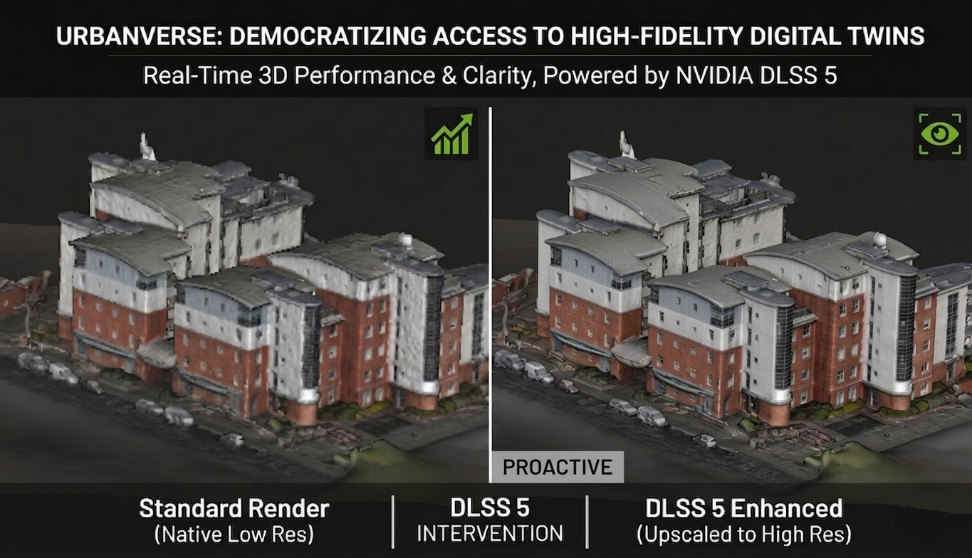
AI Processing: These massive datasets are processed using an AI filter (NVIDIA DLSS 5), which ensures the 3D models are visually stunning and "light" enough to run smoothly on standard smartphones or web browsers.
Integration: We overlay these high-resolution models onto existing global maps like Google Earth, providing a familiar and seamless context for the user.
The true value of UrbanVerse lies in its simulation capabilities. The platform allows authorities and citizens to visualize "what-if" scenarios for public safety, such as flood patterns, fire propagation in dense areas, or other climate-related disasters. By turning complex geomatic data into a visual experience, UrbanVerse empowers every citizen to see potential risks and solutions for their neighborhood, making urban evolution a matter of shared safety and informed community dialogue.
Our technical workflow is streamlined for precision and accessibility:
Data Capture: We use professional drones (UAVs) equipped with LiDAR sensors to scan the urban environment with centimeter-level accuracy.
AI Processing: These massive datasets are processed using an AI filter (NVIDIA DLSS 5), which ensures the 3D models are visually stunning and "light" enough to run smoothly on standard smartphones or web browsers.
Integration: We overlay these high-resolution models onto existing global maps like Google Earth, providing a familiar and seamless context for the user.
The true value of UrbanVerse lies in its simulation capabilities. The platform allows authorities and citizens to visualize "what-if" scenarios for public safety, such as flood patterns, fire propagation in dense areas, or other climate-related disasters. By turning complex geomatic data into a visual experience, UrbanVerse empowers every citizen to see potential risks and solutions for their neighborhood, making urban evolution a matter of shared safety and informed community dialogue.
The story of UrbanVerse began in my first year of university, when I started working in cadastre. I quickly navigated through all branches of geodesy: from engineering topography and LiDAR scanning to point cloud processing and satellite imagery management. My hands-on experience with these "cold" technical tools made me realize a profound gap: the complexity of this data often excludes the very citizens it is meant to serve.
In my second year, I founded a startup, a novel concept in Romania - built on a flexible work model for students. We secured a partnership with a major UK firm to outsource their architectural drafting. While the initial business model faced significant challenges and did not scale as expected, the collaboration remained strong. This "productive failure" was my greatest teacher; it showed me that technical precision is useless without a social purpose.
The spark for UrbanVerse came during my final year thesis. Tasked with scanning a complex building and integrating AI, I realized I could combine my entire professional background, from satellite remote sensing to centimeter-level LiDAR, into a single, democratic platform. I didn't want my thesis to be just a paper; I wanted it to be a bridge.
By overlaying high-fidelity UAV and LiDAR data onto accessible platforms like Google Earth and using AI (DLSS 5) to ensure it runs on any student’s smartphone, UrbanVerse was born. It is the culmination of my journey: from a student technician to an entrepreneur who believes that urban safety, simulating floods or fires, should be a visual, shared experience. We are moving from "drawing buildings for others" to "empowering communities to see their future." This is my commitment to the New European Bauhaus: making the invisible visible, the technical beautiful, and the future inclusive for every citizen.
In my second year, I founded a startup, a novel concept in Romania - built on a flexible work model for students. We secured a partnership with a major UK firm to outsource their architectural drafting. While the initial business model faced significant challenges and did not scale as expected, the collaboration remained strong. This "productive failure" was my greatest teacher; it showed me that technical precision is useless without a social purpose.
The spark for UrbanVerse came during my final year thesis. Tasked with scanning a complex building and integrating AI, I realized I could combine my entire professional background, from satellite remote sensing to centimeter-level LiDAR, into a single, democratic platform. I didn't want my thesis to be just a paper; I wanted it to be a bridge.
By overlaying high-fidelity UAV and LiDAR data onto accessible platforms like Google Earth and using AI (DLSS 5) to ensure it runs on any student’s smartphone, UrbanVerse was born. It is the culmination of my journey: from a student technician to an entrepreneur who believes that urban safety, simulating floods or fires, should be a visual, shared experience. We are moving from "drawing buildings for others" to "empowering communities to see their future." This is my commitment to the New European Bauhaus: making the invisible visible, the technical beautiful, and the future inclusive for every citizen.
Digital Twin
AI Visualization
Urban Resilience
Inclusive Planning
Democratized Geomatics
UrbanVerse transforms urban sustainability by shifting from reactive data collection to a proactive, resource-efficient digital ecosystem. Our concept addresses environmental and economic challenges through high-fidelity digital twins that prioritize long-term resilience.
Regarding environmental impact, the platform enables precise simulations of climate-related threats, such as floods and heat islands, using engineering-grade 3D meshes. By providing a georeferenced environment for risk modeling, we allow planners to optimize infrastructure before construction begins. This "Digital First" approach significantly reduces material waste and the carbon footprint associated with inefficient urban design or post-disaster reconstruction.
From an economic perspective, UrbanVerse addresses the "hardware barrier" to sustainability. By integrating NVIDIA DLSS 5, we ensure that massive geospatial datasets are accessible on standard, low-energy devices like smartphones. This eliminates the need for high-power, energy-intensive workstations, making advanced urban monitoring affordable for smaller municipalities. Our hybrid business model ensures economic viability by offering open-access tools for research while providing high-value analytics for professional stakeholders.
UrbanVerse is exemplary because it treats digital data as a renewable urban infrastructure. By leveraging existing tools like Unreal Engine 5 and Cesium within an ethical, GDPR-compliant framework, we provide a scalable model that can be replicated across Europe. It proves that high-tech surveying can be decoupled from high costs, creating a sustainable path for cities to monitor and adapt their built environment to future climate challenges.
Regarding environmental impact, the platform enables precise simulations of climate-related threats, such as floods and heat islands, using engineering-grade 3D meshes. By providing a georeferenced environment for risk modeling, we allow planners to optimize infrastructure before construction begins. This "Digital First" approach significantly reduces material waste and the carbon footprint associated with inefficient urban design or post-disaster reconstruction.
From an economic perspective, UrbanVerse addresses the "hardware barrier" to sustainability. By integrating NVIDIA DLSS 5, we ensure that massive geospatial datasets are accessible on standard, low-energy devices like smartphones. This eliminates the need for high-power, energy-intensive workstations, making advanced urban monitoring affordable for smaller municipalities. Our hybrid business model ensures economic viability by offering open-access tools for research while providing high-value analytics for professional stakeholders.
UrbanVerse is exemplary because it treats digital data as a renewable urban infrastructure. By leveraging existing tools like Unreal Engine 5 and Cesium within an ethical, GDPR-compliant framework, we provide a scalable model that can be replicated across Europe. It proves that high-tech surveying can be decoupled from high costs, creating a sustainable path for cities to monitor and adapt their built environment to future climate challenges.
UrbanVerse contributes to the aesthetic quality of cities by revealing the real beauty and identity of the built environment through accurate and immersive digital representation. Instead of simplified or generic urban models, the platform allows buildings and neighbourhoods to be visualized as detailed 3D meshes that reflect their true architectural form, materials, and spatial context.
By integrating these models into a georeferenced digital environment, UrbanVerse creates a living visual archive of cities. Citizens, planners, and communities can explore familiar streets and landmarks in an intuitive 3D environment, strengthening their emotional connection with the places they live in. This digital experience highlights the unique character of neighbourhoods and allows users to rediscover architectural details and urban patterns that are often overlooked in everyday life.
The platform also supports the preservation and appreciation of local architectural heritage. Historical buildings, public spaces, and distinctive urban areas can be digitally captured and visualized with high fidelity, helping communities better understand the cultural and aesthetic value of their surroundings.
Advanced real-time rendering technologies such as NVIDIA DLSS allow these detailed environments to be explored smoothly and clearly, making complex urban scenes accessible and visually engaging. This creates a more immersive and visually rich way to experience cities.
By combining geospatial data, digital twin technology, and high-quality visualization, UrbanVerse promotes a deeper appreciation for urban spaces and encourages communities to care for and value the places they inhabit. In this way, the project contributes to making cities not only smarter, but also more beautiful and meaningful for the people who live in them.
By integrating these models into a georeferenced digital environment, UrbanVerse creates a living visual archive of cities. Citizens, planners, and communities can explore familiar streets and landmarks in an intuitive 3D environment, strengthening their emotional connection with the places they live in. This digital experience highlights the unique character of neighbourhoods and allows users to rediscover architectural details and urban patterns that are often overlooked in everyday life.
The platform also supports the preservation and appreciation of local architectural heritage. Historical buildings, public spaces, and distinctive urban areas can be digitally captured and visualized with high fidelity, helping communities better understand the cultural and aesthetic value of their surroundings.
Advanced real-time rendering technologies such as NVIDIA DLSS allow these detailed environments to be explored smoothly and clearly, making complex urban scenes accessible and visually engaging. This creates a more immersive and visually rich way to experience cities.
By combining geospatial data, digital twin technology, and high-quality visualization, UrbanVerse promotes a deeper appreciation for urban spaces and encourages communities to care for and value the places they inhabit. In this way, the project contributes to making cities not only smarter, but also more beautiful and meaningful for the people who live in them.
The development of the UrbanVerse concept is based on an open and accessible workflow that allows students, researchers, and professionals to experiment with geospatial visualization technologies using widely available tools.
The initial prototype environment was designed using Unreal Engine 5, a real-time 3D engine that enables the creation of interactive digital environments. The platform integrates geospatial data through Cesium for Unreal, which allows real-world terrain and global 3D datasets such as photorealistic city models to be streamed directly into the environment.
Using this framework, users can import 3D meshes generated from drone photogrammetry or LiDAR scanning and position them accurately using their real-world geographic coordinates. This approach allows locally captured buildings or urban areas to replace simplified map representations with detailed and realistic models.
To ensure that complex urban scenes remain accessible and fluid even on standard hardware, the system integrates AI-assisted rendering technologies such as NVIDIA DLSS, which improves performance and visual clarity when exploring large 3D environments.
Because the tools used in the workflow are widely available and supported by large developer communities, the concept encourages experimentation and participation from students, researchers, and local innovation groups. This participatory approach enables users not only to visualize their cities but also to contribute new spatial data and digital models, gradually building a collaborative digital representation of urban environments.
Through this open technological framework, UrbanVerse aims to empower communities and stakeholders to actively participate in understanding and shaping the spaces they inhabit.
The initial prototype environment was designed using Unreal Engine 5, a real-time 3D engine that enables the creation of interactive digital environments. The platform integrates geospatial data through Cesium for Unreal, which allows real-world terrain and global 3D datasets such as photorealistic city models to be streamed directly into the environment.
Using this framework, users can import 3D meshes generated from drone photogrammetry or LiDAR scanning and position them accurately using their real-world geographic coordinates. This approach allows locally captured buildings or urban areas to replace simplified map representations with detailed and realistic models.
To ensure that complex urban scenes remain accessible and fluid even on standard hardware, the system integrates AI-assisted rendering technologies such as NVIDIA DLSS, which improves performance and visual clarity when exploring large 3D environments.
Because the tools used in the workflow are widely available and supported by large developer communities, the concept encourages experimentation and participation from students, researchers, and local innovation groups. This participatory approach enables users not only to visualize their cities but also to contribute new spatial data and digital models, gradually building a collaborative digital representation of urban environments.
Through this open technological framework, UrbanVerse aims to empower communities and stakeholders to actively participate in understanding and shaping the spaces they inhabit.
The development of the UrbanVerse concept is based on an open and accessible workflow that allows students, researchers, and professionals to experiment with geospatial visualization technologies using widely available tools.
The initial prototype environment was designed using Unreal Engine 5, a real-time 3D engine that enables the creation of interactive digital environments. The platform integrates geospatial data through Cesium for Unreal, which allows real-world terrain and global 3D datasets such as photorealistic city models to be streamed directly into the environment.
Using this framework, users can import 3D meshes generated from drone photogrammetry or LiDAR scanning and position them accurately using their real-world geographic coordinates. This approach allows locally captured buildings or urban areas to replace simplified map representations with detailed and realistic models.
To ensure that complex urban scenes remain accessible and fluid even on standard hardware, the system integrates AI-assisted rendering technologies such as NVIDIA DLSS, which improves performance and visual clarity when exploring large 3D environments.
Because the tools used in the workflow are widely available and supported by large developer communities, the concept encourages experimentation and participation from students, researchers, and local innovation groups. This participatory approach enables users not only to visualize their cities but also to contribute new spatial data and digital models, gradually building a collaborative digital representation of urban environments.
Through this open technological framework, UrbanVerse aims to empower communities and stakeholders to actively participate in understanding and shaping the spaces they inhabit.
The initial prototype environment was designed using Unreal Engine 5, a real-time 3D engine that enables the creation of interactive digital environments. The platform integrates geospatial data through Cesium for Unreal, which allows real-world terrain and global 3D datasets such as photorealistic city models to be streamed directly into the environment.
Using this framework, users can import 3D meshes generated from drone photogrammetry or LiDAR scanning and position them accurately using their real-world geographic coordinates. This approach allows locally captured buildings or urban areas to replace simplified map representations with detailed and realistic models.
To ensure that complex urban scenes remain accessible and fluid even on standard hardware, the system integrates AI-assisted rendering technologies such as NVIDIA DLSS, which improves performance and visual clarity when exploring large 3D environments.
Because the tools used in the workflow are widely available and supported by large developer communities, the concept encourages experimentation and participation from students, researchers, and local innovation groups. This participatory approach enables users not only to visualize their cities but also to contribute new spatial data and digital models, gradually building a collaborative digital representation of urban environments.
Through this open technological framework, UrbanVerse aims to empower communities and stakeholders to actively participate in understanding and shaping the spaces they inhabit.
The UrbanVerse concept is designed to involve stakeholders across multiple governance levels, from local communities to European institutions, in order to create a collaborative digital understanding of urban environments.
At the local level, municipalities, urban planners, surveyors, and local communities play a key role in providing spatial data and identifying areas of interest within cities. Local authorities can use the platform to visualize and monitor changes in the built environment, while citizens can explore accurate digital representations of their neighbourhoods and better understand ongoing urban transformations.
At the regional and national level, universities, research institutions, and professional organizations in geospatial engineering, architecture, and urban planning can contribute with technical expertise and datasets. These institutions can support the development of standardized workflows for capturing and integrating 3D spatial data generated through photogrammetry and LiDAR scanning.
At the European level, the concept aligns with digital and spatial data initiatives promoted by European institutions, particularly those encouraging open geospatial infrastructures and digital twins of cities. Collaboration with European research networks and innovation programmes can help scale the platform and ensure interoperability with broader spatial data ecosystems.
Technologically, the concept relies on widely used digital tools such as Unreal Engine 5, Cesium for Unreal, and AI-assisted rendering technologies such as NVIDIA DLSS, which facilitate collaboration between technical experts and non-specialist users.
The engagement of stakeholders at multiple governance levels ensures that UrbanVerse remains both technologically robust and socially relevant, enabling cities and communities to collaboratively understand and manage the evolution of their built environment.
At the local level, municipalities, urban planners, surveyors, and local communities play a key role in providing spatial data and identifying areas of interest within cities. Local authorities can use the platform to visualize and monitor changes in the built environment, while citizens can explore accurate digital representations of their neighbourhoods and better understand ongoing urban transformations.
At the regional and national level, universities, research institutions, and professional organizations in geospatial engineering, architecture, and urban planning can contribute with technical expertise and datasets. These institutions can support the development of standardized workflows for capturing and integrating 3D spatial data generated through photogrammetry and LiDAR scanning.
At the European level, the concept aligns with digital and spatial data initiatives promoted by European institutions, particularly those encouraging open geospatial infrastructures and digital twins of cities. Collaboration with European research networks and innovation programmes can help scale the platform and ensure interoperability with broader spatial data ecosystems.
Technologically, the concept relies on widely used digital tools such as Unreal Engine 5, Cesium for Unreal, and AI-assisted rendering technologies such as NVIDIA DLSS, which facilitate collaboration between technical experts and non-specialist users.
The engagement of stakeholders at multiple governance levels ensures that UrbanVerse remains both technologically robust and socially relevant, enabling cities and communities to collaboratively understand and manage the evolution of their built environment.
UrbanVerse is a transdisciplinary concept that brings together knowledge and methods from several fields in order to better understand, visualize, and manage the built environment.
At its core, the project integrates geospatial engineering and surveying, where technologies such as drone photogrammetry and LiDAR scanning are used to capture accurate spatial data and generate point clouds and 3D meshes of buildings and urban areas. These datasets form the technical foundation for creating precise digital representations of real-world environments.
The concept also incorporates architecture and urban planning, as the detailed visualization of buildings and neighbourhoods allows professionals and communities to better understand the spatial structure, evolution, and character of cities. This supports more informed discussions about urban development, heritage preservation, and spatial planning.
Digital technologies and computer graphics are another key component of the project. Interactive environments are developed using tools such as Unreal Engine 5, while geospatial integration is enabled through Cesium for Unreal, which allows real-world terrain and 3D city data to be streamed into the platform. Advanced visualization performance is supported by AI-assisted rendering technologies such as NVIDIA DLSS, enabling the exploration of highly detailed urban environments in real time.
In addition, the concept connects with social sciences and urban studies, as the platform aims to make spatial information more understandable for citizens and communities, encouraging dialogue and participation in urban development processes.
By combining geospatial science, architecture, digital visualization, and social engagement, UrbanVerse demonstrates how multiple disciplines can work together to create new tools for understanding and shaping the cities of the future.
At its core, the project integrates geospatial engineering and surveying, where technologies such as drone photogrammetry and LiDAR scanning are used to capture accurate spatial data and generate point clouds and 3D meshes of buildings and urban areas. These datasets form the technical foundation for creating precise digital representations of real-world environments.
The concept also incorporates architecture and urban planning, as the detailed visualization of buildings and neighbourhoods allows professionals and communities to better understand the spatial structure, evolution, and character of cities. This supports more informed discussions about urban development, heritage preservation, and spatial planning.
Digital technologies and computer graphics are another key component of the project. Interactive environments are developed using tools such as Unreal Engine 5, while geospatial integration is enabled through Cesium for Unreal, which allows real-world terrain and 3D city data to be streamed into the platform. Advanced visualization performance is supported by AI-assisted rendering technologies such as NVIDIA DLSS, enabling the exploration of highly detailed urban environments in real time.
In addition, the concept connects with social sciences and urban studies, as the platform aims to make spatial information more understandable for citizens and communities, encouraging dialogue and participation in urban development processes.
By combining geospatial science, architecture, digital visualization, and social engagement, UrbanVerse demonstrates how multiple disciplines can work together to create new tools for understanding and shaping the cities of the future.
The business model of the UrbanVerse concept is based on the development of a digital platform that allows the visualization and analysis of the built environment through georeferenced 3D models. The platform can be used by local administrations, construction companies, urban planning specialists, as well as research or educational institutions.
The financial sustainability of the project can be ensured through a hybrid model. A portion of the platform's functionalities could be offered for free to communities, universities, or educational projects, in order to encourage open access to geospatial information and stimulate public participation. At the same time, advanced functionalities dedicated to urban analysis, data integration, or professional visualization could be offered through subscriptions or licenses for public administrations, design companies, construction firms, or real estate developers.
Another potential revenue stream is represented by spatial data processing and integration services, such as transforming point clouds from LiDAR scans or photogrammetry into optimized 3D models for visualization within the platform.
Additionally, the development of the project can be supported in its initial phases through European funding programs for urban innovation and digitalization, including initiatives like the New European Bauhaus, but also through research grants, partnerships with universities, or pilot projects with local administrations.
The platform utilizes modern digital technologies such as Unreal Engine 5, Cesium for Unreal, and AI-assisted rendering technologies like NVIDIA DLSS, which allows for the development of a scalable infrastructure that can be gradually expanded to more cities and users.
By combining public funding with specialized digital services, UrbanVerse aims to become a financially sustainable platform capable of continuously supporting the analysis and understanding of the urban environment.
The financial sustainability of the project can be ensured through a hybrid model. A portion of the platform's functionalities could be offered for free to communities, universities, or educational projects, in order to encourage open access to geospatial information and stimulate public participation. At the same time, advanced functionalities dedicated to urban analysis, data integration, or professional visualization could be offered through subscriptions or licenses for public administrations, design companies, construction firms, or real estate developers.
Another potential revenue stream is represented by spatial data processing and integration services, such as transforming point clouds from LiDAR scans or photogrammetry into optimized 3D models for visualization within the platform.
Additionally, the development of the project can be supported in its initial phases through European funding programs for urban innovation and digitalization, including initiatives like the New European Bauhaus, but also through research grants, partnerships with universities, or pilot projects with local administrations.
The platform utilizes modern digital technologies such as Unreal Engine 5, Cesium for Unreal, and AI-assisted rendering technologies like NVIDIA DLSS, which allows for the development of a scalable infrastructure that can be gradually expanded to more cities and users.
By combining public funding with specialized digital services, UrbanVerse aims to become a financially sustainable platform capable of continuously supporting the analysis and understanding of the urban environment.
UrbanVerse is designed as a scalable and transferable concept that can be replicated in different cities, regions, and countries. The platform relies on widely available digital technologies and standardized geospatial data workflows, making it adaptable to a variety of urban contexts.
One of the most easily replicable elements is the technological framework used to visualize georeferenced 3D models of buildings and urban environments. By using widely adopted tools such as Unreal Engine 5 for real-time visualization and Cesium for Unreal for integrating global geospatial data, the platform can be deployed in different locations without requiring entirely new infrastructure.
The methodology for generating the models is also highly transferable. Buildings and urban areas can be captured using drone photogrammetry or LiDAR scanning, producing point clouds that are then processed into optimized 3D meshes. This workflow is already used in many surveying and geospatial engineering contexts, allowing cities or organizations in different regions to apply the same process using existing equipment and expertise.
Additionally, the platform is designed to handle large and complex datasets through AI-assisted rendering technologies such as NVIDIA DLSS, which makes it possible to visualize detailed urban environments efficiently across different hardware configurations.
Beyond the technology itself, the concept encourages a collaborative approach in which local communities, universities, and municipalities can contribute spatial data and develop localized digital twins of their cities. This model allows UrbanVerse to gradually expand into a network of interconnected digital representations of urban environments.
Because the workflow, tools, and participation model can be reproduced in many contexts, UrbanVerse has strong potential to scale across different European cities and contribute to a broader digital understanding of urban development.
One of the most easily replicable elements is the technological framework used to visualize georeferenced 3D models of buildings and urban environments. By using widely adopted tools such as Unreal Engine 5 for real-time visualization and Cesium for Unreal for integrating global geospatial data, the platform can be deployed in different locations without requiring entirely new infrastructure.
The methodology for generating the models is also highly transferable. Buildings and urban areas can be captured using drone photogrammetry or LiDAR scanning, producing point clouds that are then processed into optimized 3D meshes. This workflow is already used in many surveying and geospatial engineering contexts, allowing cities or organizations in different regions to apply the same process using existing equipment and expertise.
Additionally, the platform is designed to handle large and complex datasets through AI-assisted rendering technologies such as NVIDIA DLSS, which makes it possible to visualize detailed urban environments efficiently across different hardware configurations.
Beyond the technology itself, the concept encourages a collaborative approach in which local communities, universities, and municipalities can contribute spatial data and develop localized digital twins of their cities. This model allows UrbanVerse to gradually expand into a network of interconnected digital representations of urban environments.
Because the workflow, tools, and participation model can be reproduced in many contexts, UrbanVerse has strong potential to scale across different European cities and contribute to a broader digital understanding of urban development.
Following the application, the next year will focus on developing a functional prototype of the UrbanVerse platform and testing it in a real urban context. The first step will consist of building a working digital environment capable of integrating georeferenced 3D meshes of buildings into a real-world geographic framework.
During the initial phase, the prototype will be developed using Unreal Engine 5, together with Cesium for Unreal, which allows the integration of real-world terrain and global geospatial data into an interactive 3D environment. In parallel, buildings or small urban areas will be captured through drone photogrammetry or LiDAR scanning, generating point clouds that will be processed into optimized 3D meshes.
These models will then be integrated into the platform at their correct geographic coordinates, replacing simplified building representations with accurate digital replicas. To ensure smooth real-time visualization of complex urban environments, the prototype will also integrate AI-assisted rendering technologies such as NVIDIA DLSS.
Once the prototype is functional, a pilot demonstration will be prepared using a selected neighbourhood or urban area. This pilot will help evaluate the usability of the platform and demonstrate how accurate digital twins of real environments can support better understanding of urban spaces.
At the same time, the concept will be promoted through collaboration with universities, geospatial professionals, and local stakeholders interested in digital representations of cities. These collaborations will help refine the concept, expand the dataset, and explore future applications of the platform in urban analysis, planning, and public engagement.
Through these steps, the first year after the application will focus on transforming the concept into a working demonstrator capable of illustrating the practical potential of UrbanVerse.
During the initial phase, the prototype will be developed using Unreal Engine 5, together with Cesium for Unreal, which allows the integration of real-world terrain and global geospatial data into an interactive 3D environment. In parallel, buildings or small urban areas will be captured through drone photogrammetry or LiDAR scanning, generating point clouds that will be processed into optimized 3D meshes.
These models will then be integrated into the platform at their correct geographic coordinates, replacing simplified building representations with accurate digital replicas. To ensure smooth real-time visualization of complex urban environments, the prototype will also integrate AI-assisted rendering technologies such as NVIDIA DLSS.
Once the prototype is functional, a pilot demonstration will be prepared using a selected neighbourhood or urban area. This pilot will help evaluate the usability of the platform and demonstrate how accurate digital twins of real environments can support better understanding of urban spaces.
At the same time, the concept will be promoted through collaboration with universities, geospatial professionals, and local stakeholders interested in digital representations of cities. These collaborations will help refine the concept, expand the dataset, and explore future applications of the platform in urban analysis, planning, and public engagement.
Through these steps, the first year after the application will focus on transforming the concept into a working demonstrator capable of illustrating the practical potential of UrbanVerse.