Enablers for New European Bauhaus Transformation
UrbanWeave
UrbanWeave: Knitting Beauty, Data and History Budapest's Urban Fabric
UrbanWeave is a roadmap to belonging in Budapest. Designed for newcomers and locals alike, our project tackles housing opacity and city stress through a Rent Predictor for fair market transparency, a Scenic Router that trades ‘fast paths’ for urban beauty, and a Digital Heritage layer to reveal the city’s layers of history. By fusing data science with wellbeing, we turn the urban grid into a restorative landscape of beauty and inclusion.
Hungary
Local
Budapest
Mainly urban
It refers to other types of transformations (soft investment)
Prototype level
No
No
No
Individual
Our concept addresses three frictions in urban living: housing opacity, navigational anxiety, and social alienation. Newcomers to Budapest, including students and expat professionals, often face information asymmetry in rentals and difficulties experiencing the city’s geography soulfully. Our project provides a modular urban intelligence interface that transforms city data into a tool for transparency, restorative mobility, and cultural belonging.
The platform serves a diverse number of groups, including international students and researchers, expats and digital nomads, long-term residents, and cultural enthusiasts.
The three frictions are objectively targeted through:
-A data-driven engine that provides housing market transparency (Budapest Rent Predictor), allowing users to benchmark fair prices and mitigate predatory listing practices.
-An inclusive scenic route navigation that transcends short-path efficiency by weighting pathways based on architectural beauty, quietness, and walkability, offering restoration amidst urban chaos.
-A digital heritage layer that reveals the hidden cultural value of the built environment, turning streets into an open-air museum.
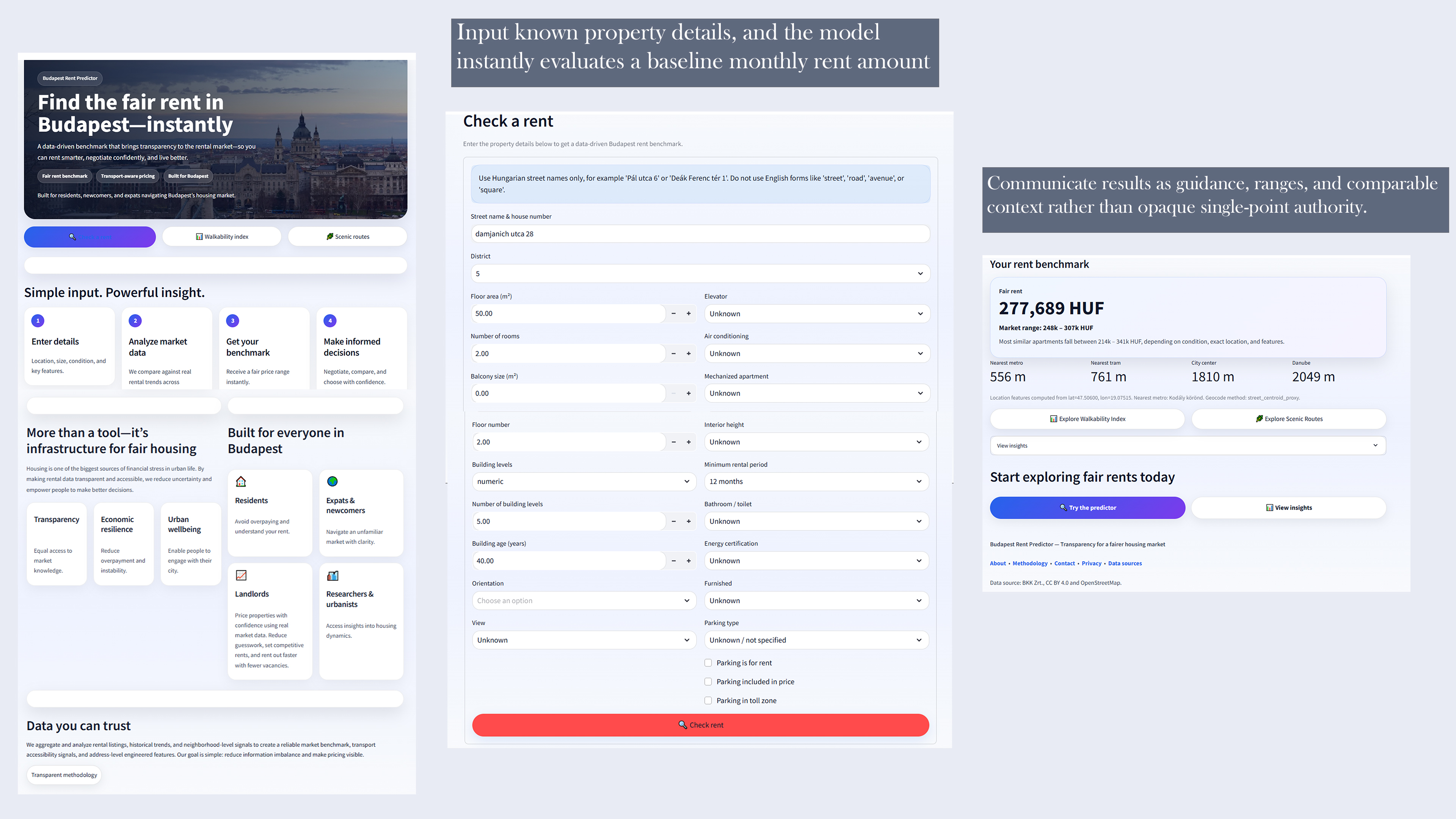
We have successfully developed a functioning Python/Streamlit prototype focused on Budapest’s Districts V, VI and VII. It integrates OpenStreetMap APIs with custom weighting criteria. Research stage feedback from student focus groups indicates that 85% welcomed a scenic route alternative, while the rent predictor provided a needed sense of real estate navigation.
Our synthesis of qualitative data (rent/logistics) with qualitative experience (aesthetics) is forward-looking. We boast a comprehensive tool that toggles between efficiency and well-being on one interface. The city is not simply a grid, but a landscape to be experienced. We offer a model for digital stewardship, in line with the New European Bauhaus’s value of beauty, sustainability, and togetherness.
The platform serves a diverse number of groups, including international students and researchers, expats and digital nomads, long-term residents, and cultural enthusiasts.
The three frictions are objectively targeted through:
-A data-driven engine that provides housing market transparency (Budapest Rent Predictor), allowing users to benchmark fair prices and mitigate predatory listing practices.
-An inclusive scenic route navigation that transcends short-path efficiency by weighting pathways based on architectural beauty, quietness, and walkability, offering restoration amidst urban chaos.
-A digital heritage layer that reveals the hidden cultural value of the built environment, turning streets into an open-air museum.
We have successfully developed a functioning Python/Streamlit prototype focused on Budapest’s Districts V, VI and VII. It integrates OpenStreetMap APIs with custom weighting criteria. Research stage feedback from student focus groups indicates that 85% welcomed a scenic route alternative, while the rent predictor provided a needed sense of real estate navigation.
Our synthesis of qualitative data (rent/logistics) with qualitative experience (aesthetics) is forward-looking. We boast a comprehensive tool that toggles between efficiency and well-being on one interface. The city is not simply a grid, but a landscape to be experienced. We offer a model for digital stewardship, in line with the New European Bauhaus’s value of beauty, sustainability, and togetherness.
Our journey began not as locals, but as observers. We arrived in Budapest as foreigners, beginning our pursuit of education. Though we arrived at different times, we shared a common experience. Navigating the friction of the housing market, a struggle many before us have faced in a city that often lacks a clear guide for those who do not yet speak the language.
Over time, Budapest revealed itself to us through informal discovery rather than guidebooks. We stumbled upon Scenic routes that remain hidden when compared to the glittering Danube paths. We realized that Budapest’s historic building stock is a silent witness to centuries of history and has stories to tell. We concluded that while newcomers are often too overwhelmed by the act of settling in to see the beauty around them, long-term residents can sometimes lose that sense of wonder as these marvels become a mere backdrop to a daily commute. To bridge this gap, we transformed our perspective into a functional digital module:
1. We built the Rent Predictor. Using machine learning workflow implemented in Python and deployed through Streamlit for visualization and testing, we curated high-quality, GDPR-compliant datasets to model housing trends to create a Fair Market Benchmark providing the economic security necessary for residents to look up from their financial stress and engage with their surroundings.
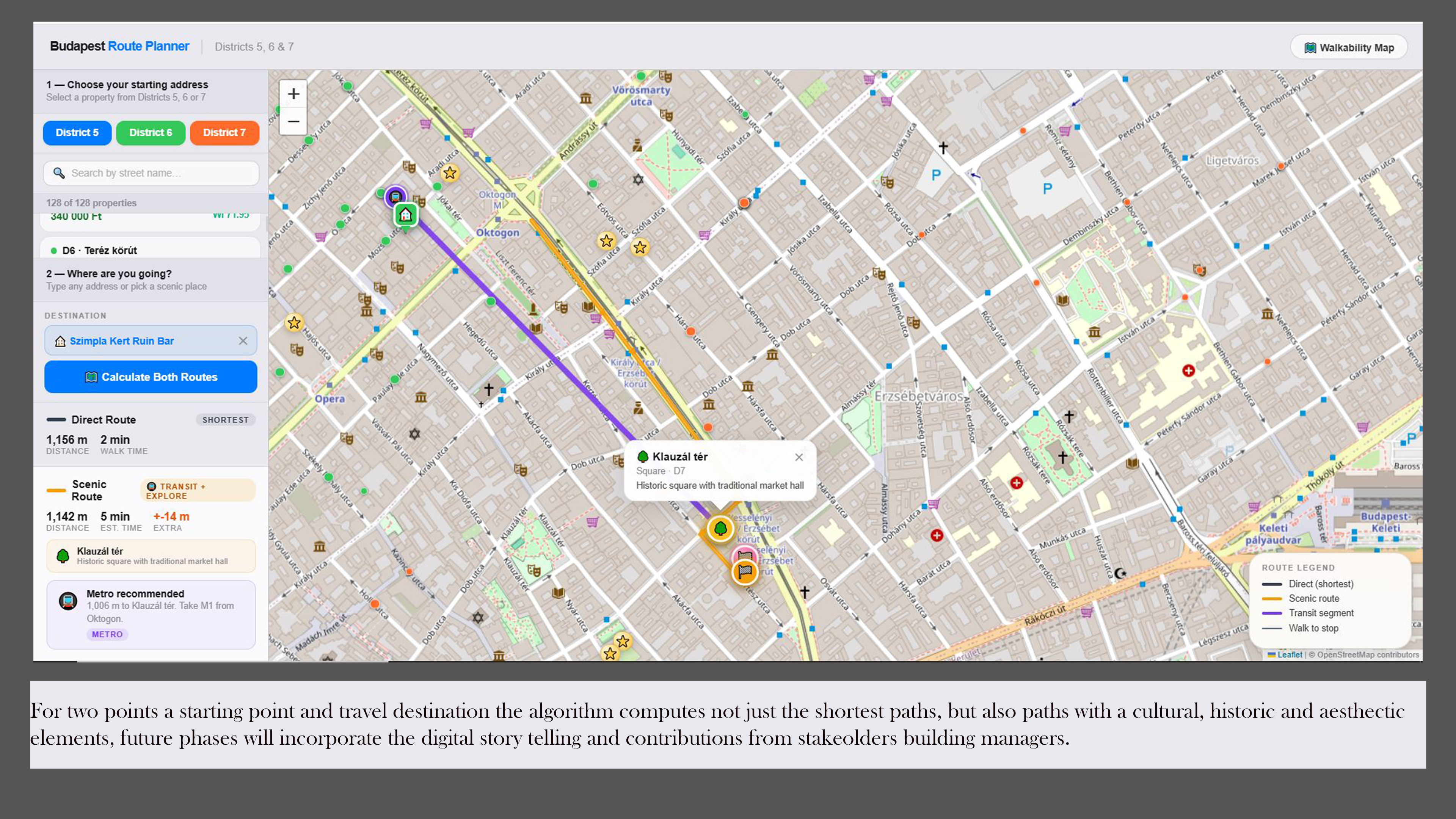
2. Using OpenStreetMap APIs, we engineer a custom layer over the standard city grid. We moved beyond Shortest Path logic to capture Scenic logic, digitizing the informal, restorative walks we discovered as students.
3. Consulting the NEB Compass, we expanded our focus to include those with physical barriers. We are currently integrating multisensory wayfinding using auditory cues and haptic feedback to ensure the spirit of place is a shared sensory reality for the visually impaired. We aim to peel back the layers of the everyday. We’re building a tool that rekindles wonder for locals and visitors alike.
Over time, Budapest revealed itself to us through informal discovery rather than guidebooks. We stumbled upon Scenic routes that remain hidden when compared to the glittering Danube paths. We realized that Budapest’s historic building stock is a silent witness to centuries of history and has stories to tell. We concluded that while newcomers are often too overwhelmed by the act of settling in to see the beauty around them, long-term residents can sometimes lose that sense of wonder as these marvels become a mere backdrop to a daily commute. To bridge this gap, we transformed our perspective into a functional digital module:
1. We built the Rent Predictor. Using machine learning workflow implemented in Python and deployed through Streamlit for visualization and testing, we curated high-quality, GDPR-compliant datasets to model housing trends to create a Fair Market Benchmark providing the economic security necessary for residents to look up from their financial stress and engage with their surroundings.
2. Using OpenStreetMap APIs, we engineer a custom layer over the standard city grid. We moved beyond Shortest Path logic to capture Scenic logic, digitizing the informal, restorative walks we discovered as students.
3. Consulting the NEB Compass, we expanded our focus to include those with physical barriers. We are currently integrating multisensory wayfinding using auditory cues and haptic feedback to ensure the spirit of place is a shared sensory reality for the visually impaired. We aim to peel back the layers of the everyday. We’re building a tool that rekindles wonder for locals and visitors alike.
Urban affordability
Inclusive city innovation
Accessible city experience
Cultural heritage discovery
Data-as-a-Service
Our project maximizes the use of what already exists in Budapest. The tool acts as a digital information layer that uses the city’s existing infrastructure. The project bypasses the need for hardware; instead, it uses open-source data and existing web technologies to make urban living more efficient. We prioritize three data-driven pillars:
Promotion of Soft Mobility via Routing: By integrating a Scenic Route algorithm alongside the standard Shortest Path, we focus on shade density, historic frontage, and acoustic comfort. Our approach redesigns pedestrian flow by diverting foot traffic away from busy arterial roads and onto underused side streets.
Our approach is practical: We use API data (i.e., OpenStreetMap) combined with custom routing weights to prioritize pedestrian paths that are shaded and historic, rather than merely the shortest distance.
Economic Sustainability & Market Transparency: The Budapest Rent Predictor democratizes data on the local housing market. By aggregating and visualizing real estate trends, we provide a transparency tool for both local and expat demographics. By equipping residents with the evidence needed to navigate fair market pricing, the information imbalance that often accelerates social displacement is mitigated. Our functional model serves as a digital benchmark, enabling users to make informed decisions.
Digital Stewardship of Local Assets: We provide a low-barrier platform for facility managers and cultural stakeholders to claim their digital presence. By allowing them to add descriptions regarding a building’s heritage or current usage, we encourage the adaptive reuse of the existing building stock. From a circular economy perspective, providing visibility to existing assets is the most efficient way to prevent urban decay and showcase the latent value of Budapest’s building stock.
Promotion of Soft Mobility via Routing: By integrating a Scenic Route algorithm alongside the standard Shortest Path, we focus on shade density, historic frontage, and acoustic comfort. Our approach redesigns pedestrian flow by diverting foot traffic away from busy arterial roads and onto underused side streets.
Our approach is practical: We use API data (i.e., OpenStreetMap) combined with custom routing weights to prioritize pedestrian paths that are shaded and historic, rather than merely the shortest distance.
Economic Sustainability & Market Transparency: The Budapest Rent Predictor democratizes data on the local housing market. By aggregating and visualizing real estate trends, we provide a transparency tool for both local and expat demographics. By equipping residents with the evidence needed to navigate fair market pricing, the information imbalance that often accelerates social displacement is mitigated. Our functional model serves as a digital benchmark, enabling users to make informed decisions.
Digital Stewardship of Local Assets: We provide a low-barrier platform for facility managers and cultural stakeholders to claim their digital presence. By allowing them to add descriptions regarding a building’s heritage or current usage, we encourage the adaptive reuse of the existing building stock. From a circular economy perspective, providing visibility to existing assets is the most efficient way to prevent urban decay and showcase the latent value of Budapest’s building stock.
The Concept redefines urban aesthetics by shifting the focus from visually appealing facades to the holistic quality of the urban experience. The move beyond ‘shortest path’ navigation prioritizes human well-being and cultural resonance.
This Scenic routing algorithm emphasizes everyday beauty. By weighting paths based on acoustic comfort, visual greenery, and architectural rhythm, we transform routine commutes into a restorative experience. This directly targets users’ mental well-being and sensory comfort: a micro-escape from urban stressors. For the visually impaired, this experience aims to cater to multisensory beauty through audio-spatial descriptions of architectural styles and haptic feedback. We believe that the spirit of place should be a shared sensory reality.
We integrate design and heritage by allowing verified stakeholders, including local museums, to embed their physical archives into the digital map. This layer brings the craftsmanship of the past into the digital present. A user is invited to engage with the intangible heritage and the artistic stories behind the facades, effectively bringing history closer to people. By providing a platform for facility managers and residents to highlight local narratives, we foster a sense of belonging. Our project treats the city as a living narrative, not just a static grid. When residents understand the cultural weight and craftsmanship of their surroundings, they become better stewards of Budapest.
Our concept is exemplary because it democratizes urban curation. While most mapping tools are commercial or utility-driven, ours is value-driven. It stands out by linking the digital functionality of our data model with the nuanced reality of the urban walk.
This Scenic routing algorithm emphasizes everyday beauty. By weighting paths based on acoustic comfort, visual greenery, and architectural rhythm, we transform routine commutes into a restorative experience. This directly targets users’ mental well-being and sensory comfort: a micro-escape from urban stressors. For the visually impaired, this experience aims to cater to multisensory beauty through audio-spatial descriptions of architectural styles and haptic feedback. We believe that the spirit of place should be a shared sensory reality.
We integrate design and heritage by allowing verified stakeholders, including local museums, to embed their physical archives into the digital map. This layer brings the craftsmanship of the past into the digital present. A user is invited to engage with the intangible heritage and the artistic stories behind the facades, effectively bringing history closer to people. By providing a platform for facility managers and residents to highlight local narratives, we foster a sense of belonging. Our project treats the city as a living narrative, not just a static grid. When residents understand the cultural weight and craftsmanship of their surroundings, they become better stewards of Budapest.
Our concept is exemplary because it democratizes urban curation. While most mapping tools are commercial or utility-driven, ours is value-driven. It stands out by linking the digital functionality of our data model with the nuanced reality of the urban walk.
The project addresses inclusion by dismantling the information and physical barriers that traditionally restrict access to urban life, ensuring that the city is a design-for-all environment.
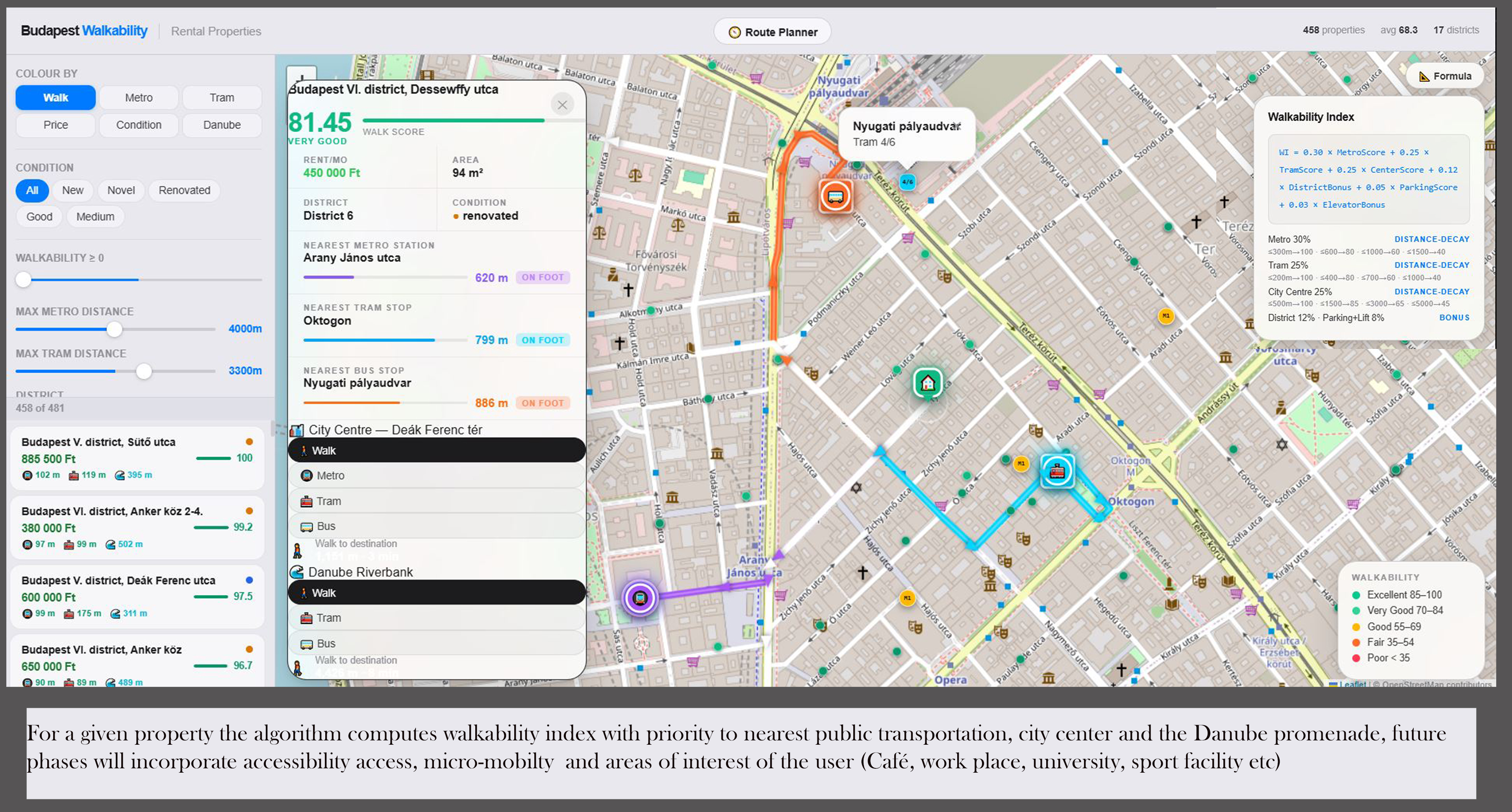
First, our Budapest Rent Predictor tackles the socio-economic challenge of housing affordability by providing transparency in information in a volatile market. We omit the price speculation barrier that effectively marginalizes demographics, including students, young professionals, and low-income families, when searching for homes. This data-driven empowerment prevents social cleansing and ensures a diverse demographic mix. Crucially, our model integrates accessibility and transport proximity as core variables, allowing users to find homes that meet their specific mobility needs. By providing real-time data on public transportation facilities and street-level obstacles, we ensure that the Right to the City is a shared reality.
We promote a multi-stakeholder governance model by transforming the map into a Digital Commons. Through the interface, our platform gives bottom-up actors agency, including local NGOs, accessibility advocates, and small-scale facility managers, to contribute to a shared knowledge base. This ensures that the city’s narrative is co-authored by its own community, truly reflecting Budapest’s social fabric.
The concept is an exemplary achievement of Ambition Level III (Transform) of the NEB Compass. We do not simply assist marginalized groups; we rebalance the city’s power dynamics. We want to prove that an inclusive city is both affordable to inhabit and accessible to navigate.
First, our Budapest Rent Predictor tackles the socio-economic challenge of housing affordability by providing transparency in information in a volatile market. We omit the price speculation barrier that effectively marginalizes demographics, including students, young professionals, and low-income families, when searching for homes. This data-driven empowerment prevents social cleansing and ensures a diverse demographic mix. Crucially, our model integrates accessibility and transport proximity as core variables, allowing users to find homes that meet their specific mobility needs. By providing real-time data on public transportation facilities and street-level obstacles, we ensure that the Right to the City is a shared reality.
We promote a multi-stakeholder governance model by transforming the map into a Digital Commons. Through the interface, our platform gives bottom-up actors agency, including local NGOs, accessibility advocates, and small-scale facility managers, to contribute to a shared knowledge base. This ensures that the city’s narrative is co-authored by its own community, truly reflecting Budapest’s social fabric.
The concept is an exemplary achievement of Ambition Level III (Transform) of the NEB Compass. We do not simply assist marginalized groups; we rebalance the city’s power dynamics. We want to prove that an inclusive city is both affordable to inhabit and accessible to navigate.
Since our concept is participatory, it involves the direct input from the communities it is intended for to shape its long-term value. Beneficiaries include international students, researchers, expat professionals, digital nomads, long-term residents, and culture enthusiasts. It also benefits and affects the local actors, accessibility advocates, and housing stakeholders whose knowledge is essential to enriching our inclusive urban platform.
Participation began from our lived experiences as newcomers navigating Budapest’s housing opacity and accessing the city beyond the visible layers. We have engaged in early structures consultations and feedback sessions with members of the international student and expat community, in the latter third of 2025. Feedback revealed that individuals not only seek fairer housing information but also a greater sense of belonging and familiarity with the city’s heritage.
The outcome of this participation had a solid impact on our concept; it triggered the strategic decision to shift from not only building a single-purpose rent predictor but to integrate scenic and inclusive mobility and cultural storytelling. It influenced our concept in the direction of strategic refinement.
Looking ahead, participation is built into the platform’s governance model. We are designing it as a collaborative digital commons in which museums, local NGOs, facility managers, accessibility advocates, and cultural stakeholders can contribute verified content, urban narratives, and accessibility knowledge. Their role is not passive; they become co-authors of the city’s digital layer.
The participatory process made the concept more relevant, more inclusive, and more responsive to real needs. We are not just acting on shared experiences of only three individuals, but on the experiences of people and communities to better serve them.
Participation began from our lived experiences as newcomers navigating Budapest’s housing opacity and accessing the city beyond the visible layers. We have engaged in early structures consultations and feedback sessions with members of the international student and expat community, in the latter third of 2025. Feedback revealed that individuals not only seek fairer housing information but also a greater sense of belonging and familiarity with the city’s heritage.
The outcome of this participation had a solid impact on our concept; it triggered the strategic decision to shift from not only building a single-purpose rent predictor but to integrate scenic and inclusive mobility and cultural storytelling. It influenced our concept in the direction of strategic refinement.
Looking ahead, participation is built into the platform’s governance model. We are designing it as a collaborative digital commons in which museums, local NGOs, facility managers, accessibility advocates, and cultural stakeholders can contribute verified content, urban narratives, and accessibility knowledge. Their role is not passive; they become co-authors of the city’s digital layer.
The participatory process made the concept more relevant, more inclusive, and more responsive to real needs. We are not just acting on shared experiences of only three individuals, but on the experiences of people and communities to better serve them.
The project relies on multilevel governance to address challenges in affordable living, inclusive mobility, cultural visibility, and digital access. We envision the platform as an ecosystem that connects various actors together.
At the local level, our key stakeholders include residents, students, expats, tourists, museums, local NGOs, heritage actors, and real estate agencies. The involvement of these stakeholders provides specific knowledge regarding housing data, building histories, accessibility observations, and user feedback. Their engagement ensures the platform is accurate and rooted in everyday reality.
We foresee engagement with district administrations, tourism actors, and public cultural institutions at the municipal level. Our immediate focus is on Districts with built heritage and higher visitor flows. Their added value lies in enabling alignment with local development priorities, cultural programming, accessibility strategies, and place-based regeneration efforts.
We anticipate connecting with actors at the national level in higher education, tourism, and heritage working on digitalization. Their support would lead to wider visibility, policy alignment, and involvement in innovation programs.
At the European level, it strongly aligns with the New European Bauhaus, the EU Urban Agenda, and broader European priorities around inclusion, mobility, cultural heritage, and digital transformation. European engagement brings methodological legitimacy, opportunities for knowledge exchange, and pathways for transfer to other cities.
The added value of this multilevel approach is that it combines bottom-up knowledge with institutional support. It makes the concept more resilient, more legitimate, and more scalable. Rather than functioning as a stand-alone app, the platform becomes a shared governance instrument that connects citizens, data, culture, and policy in one urban interface.
At the local level, our key stakeholders include residents, students, expats, tourists, museums, local NGOs, heritage actors, and real estate agencies. The involvement of these stakeholders provides specific knowledge regarding housing data, building histories, accessibility observations, and user feedback. Their engagement ensures the platform is accurate and rooted in everyday reality.
We foresee engagement with district administrations, tourism actors, and public cultural institutions at the municipal level. Our immediate focus is on Districts with built heritage and higher visitor flows. Their added value lies in enabling alignment with local development priorities, cultural programming, accessibility strategies, and place-based regeneration efforts.
We anticipate connecting with actors at the national level in higher education, tourism, and heritage working on digitalization. Their support would lead to wider visibility, policy alignment, and involvement in innovation programs.
At the European level, it strongly aligns with the New European Bauhaus, the EU Urban Agenda, and broader European priorities around inclusion, mobility, cultural heritage, and digital transformation. European engagement brings methodological legitimacy, opportunities for knowledge exchange, and pathways for transfer to other cities.
The added value of this multilevel approach is that it combines bottom-up knowledge with institutional support. It makes the concept more resilient, more legitimate, and more scalable. Rather than functioning as a stand-alone app, the platform becomes a shared governance instrument that connects citizens, data, culture, and policy in one urban interface.
Our concept is transdisciplinary, both in its design and the founding members' expertise. Our collective knowledge spans Civil, Geo, Environmental, and Data Engineering, as well as Data Science, Urban Design, and Social Sciences.
-The first co-author has a background in Civil and Data Engineering, contributing foundational knowledge in spatial systems, infrastructural logic, and data architecture.
-The second co-author is trained in Civil/Environmental Engineering and Data Science. This expertise provides the necessary sustainability-oriented analysis and high-performance, data-driven modeling.
-The third co-author holds an MSc in Urban Design and Architecture and is a Doctoral Researcher in Social Sciences in Architecture. Their expertise bridges the knowledge gap related to the cultural, experiential, and social dimensions of placemaking.
This diversity of experience has shaped the project since its conception through a non-hierarchical, iterative development cycle. Instead of treating these fields as independent, we aimed for synergy within their overlapping layers. We organized as follows:
-We engaged bi-weekly to discuss urban theories, including the "Right to the City" and the "15-Minute City," which informed our definition of the "Spirit of Place." The outcomes of these discussions were translated into the weighted parameters guiding our model exercises and the overall project.
-Major design choices such as the integration of multisensory wayfinding underwent a thorough three-person review to ensure it was technically operational, evidence-based, and socially grounded.
-Outcomes were determined by consensus, ensuring that technical efficiency never overshadowed human-centered well-being.
The process is not only functional but culturally aware and socially rooted. By integrating quantitative environmental data with qualitative human-centered perspectives, we have developed a multidimensional tool capable of addressing urban life in a holistic way.
-The first co-author has a background in Civil and Data Engineering, contributing foundational knowledge in spatial systems, infrastructural logic, and data architecture.
-The second co-author is trained in Civil/Environmental Engineering and Data Science. This expertise provides the necessary sustainability-oriented analysis and high-performance, data-driven modeling.
-The third co-author holds an MSc in Urban Design and Architecture and is a Doctoral Researcher in Social Sciences in Architecture. Their expertise bridges the knowledge gap related to the cultural, experiential, and social dimensions of placemaking.
This diversity of experience has shaped the project since its conception through a non-hierarchical, iterative development cycle. Instead of treating these fields as independent, we aimed for synergy within their overlapping layers. We organized as follows:
-We engaged bi-weekly to discuss urban theories, including the "Right to the City" and the "15-Minute City," which informed our definition of the "Spirit of Place." The outcomes of these discussions were translated into the weighted parameters guiding our model exercises and the overall project.
-Major design choices such as the integration of multisensory wayfinding underwent a thorough three-person review to ensure it was technically operational, evidence-based, and socially grounded.
-Outcomes were determined by consensus, ensuring that technical efficiency never overshadowed human-centered well-being.
The process is not only functional but culturally aware and socially rooted. By integrating quantitative environmental data with qualitative human-centered perspectives, we have developed a multidimensional tool capable of addressing urban life in a holistic way.
Our concept is a mission-driven digital platform with a hybrid business model, combining public value with financial sustainability. The public interest functions include housing transparency, inclusive navigation, and heritage discovery. It is intended to remain accessible through partnerships, service-based revenues, and innovation funding.
We are looking toward public innovation funds, university collaborations, and strategic partnerships with municipalities, cultural institutions, and housing-related actors for financing. At this stage, our primary objective is building value, validating demand, and gaining social and market relevance.
As the platform matures, we move toward a diversified revenue model:
Municipalities and cultural institutions (museums, tourism boards) pay for customized data modules and high-visibility Heritage layers that drive foot traffic to specific sites.
Real estate professionals and housing providers access premium neighborhood insights to reduce vacancy periods and increase market trust.
Providing anonymized, GDPR-compliant urban mobility patterns to researchers and city planners to inform future accessibility infrastructure.
Additional future options include premium thematic routes, curated cultural content, or in-app services for visitors.
The cost of implementation is modest and is largely related to platform development, maintenance, hosting, and human resources. The costs of digital infrastructure and modular design are primarily covered by the project team while discussions with potential supporting partners are ongoing.
Our business model supports implementation, continuity, and scalability through low operating costs and diversifying income streams. Anonymized and GDPR-compliant platform data could support researchers and authorities in identifying housing, mobility, and accessibility patterns. The spatial haptic and audio guidance features could make the model a reference for more inclusive urban innovation in Budapest.
We are looking toward public innovation funds, university collaborations, and strategic partnerships with municipalities, cultural institutions, and housing-related actors for financing. At this stage, our primary objective is building value, validating demand, and gaining social and market relevance.
As the platform matures, we move toward a diversified revenue model:
Municipalities and cultural institutions (museums, tourism boards) pay for customized data modules and high-visibility Heritage layers that drive foot traffic to specific sites.
Real estate professionals and housing providers access premium neighborhood insights to reduce vacancy periods and increase market trust.
Providing anonymized, GDPR-compliant urban mobility patterns to researchers and city planners to inform future accessibility infrastructure.
Additional future options include premium thematic routes, curated cultural content, or in-app services for visitors.
The cost of implementation is modest and is largely related to platform development, maintenance, hosting, and human resources. The costs of digital infrastructure and modular design are primarily covered by the project team while discussions with potential supporting partners are ongoing.
Our business model supports implementation, continuity, and scalability through low operating costs and diversifying income streams. Anonymized and GDPR-compliant platform data could support researchers and authorities in identifying housing, mobility, and accessibility patterns. The spatial haptic and audio guidance features could make the model a reference for more inclusive urban innovation in Budapest.
The Concept is transferable since it is built as a modular urban intelligence framework solution. Districts V, VI, and VII are our pilot locations, as it serves as a functional urban laboratory where centuries-old heritage meets with intense tourism to showcase the Twin Transition challenges facing historic European cities.
The most replicable elements are the Scenic Routing, inclusive navigation and cultural storytelling, as these rely largely on open-access spatial, cultural, and environmental data combined with our own algorithmic logic. These parts can be adapted to other cities by recalibrating route-weighting criteria and local content layers to reflect context-specific priorities such as walkability, accessibility, heritage density, green space, or cultural landmarks. The Rent Predictor is also replicable but requires retraining with local housing market data and variables.
The replication of the concept and success in deployment requires a transdisciplinary skillset similar to our team’s, and partnerships with actors who can provide quality local datasets and implementation support from cultural and heritage preservation actors to populate the Digital Commons layer. Key partners may include municipalities, universities, NGOs, and housing-related actors.
While the technical setup is universal, the context must be well grounded. The adaptations require:
-Retraining the model to comply with local market variables and GDPR-compliant datasets.
-Engaging locals in curating the narrative of what constitutes beauty and heritage in their specific context.
-Aligning with existing municipal digital infrastructure or national open-data portals.
Urban belonging is curated through the combination of data, accessibility, and thorough narratives. Our concept can be scaled across various locations for beauty, inclusion, and human-centred digital services. Because the technical backbone is modular, adaptations are feasible across cities like Prague or Kraków.
The most replicable elements are the Scenic Routing, inclusive navigation and cultural storytelling, as these rely largely on open-access spatial, cultural, and environmental data combined with our own algorithmic logic. These parts can be adapted to other cities by recalibrating route-weighting criteria and local content layers to reflect context-specific priorities such as walkability, accessibility, heritage density, green space, or cultural landmarks. The Rent Predictor is also replicable but requires retraining with local housing market data and variables.
The replication of the concept and success in deployment requires a transdisciplinary skillset similar to our team’s, and partnerships with actors who can provide quality local datasets and implementation support from cultural and heritage preservation actors to populate the Digital Commons layer. Key partners may include municipalities, universities, NGOs, and housing-related actors.
While the technical setup is universal, the context must be well grounded. The adaptations require:
-Retraining the model to comply with local market variables and GDPR-compliant datasets.
-Engaging locals in curating the narrative of what constitutes beauty and heritage in their specific context.
-Aligning with existing municipal digital infrastructure or national open-data portals.
Urban belonging is curated through the combination of data, accessibility, and thorough narratives. Our concept can be scaled across various locations for beauty, inclusion, and human-centred digital services. Because the technical backbone is modular, adaptations are feasible across cities like Prague or Kraków.
Our priority is to move from prototype to a validated pilot implementation in Budapest.
First, we will strengthen the platform’s technical and operational foundation while building the partnerships needed for implementation. This includes refining the Budapest Rent Predictor, improving the scenic and inclusive routing logic, and developing the first version of the cultural and heritage layer. In parallel, we will collaborate with selected real estate agencies, museums, and community organisations. For housing actors, the value proposition is clear: in exchange for data collaboration and beta access to heatmap-based insights and platform visibility, they benefit from more informed renters and potentially shorter listing vacancy times. On the technical side, we will further develop the CI/CD workflow and data pipeline to support larger-scale data ingestion, model refinement, interface usability, multilingual access, and GDPR-compliant processes.
Second, we will launch a pilot validation phase with key user groups, including students, researchers, expats, residents, and culturally motivated visitors. This phase will generate structured feedback on usability, trust, and relevance. We will test accessibility-oriented features, including pathways toward audio guidance and other multisensory navigation tools.
Third, we will invest in communication and visibility through university networks, expat communities, local events, innovation ecosystems, and digital outreach. The goal is to position the platform not only as a practical tool for housing and navigation, but as a new way of experiencing and belonging in the city.
Finally, we will prepare the next stage of implementation by documenting lessons learned, identifying sustainable funding and business pathways, and defining a transfer model for replication in other cities. Detailed workplan, barriers to implementation and mitigation measures will be presented in the mandatory document section.
First, we will strengthen the platform’s technical and operational foundation while building the partnerships needed for implementation. This includes refining the Budapest Rent Predictor, improving the scenic and inclusive routing logic, and developing the first version of the cultural and heritage layer. In parallel, we will collaborate with selected real estate agencies, museums, and community organisations. For housing actors, the value proposition is clear: in exchange for data collaboration and beta access to heatmap-based insights and platform visibility, they benefit from more informed renters and potentially shorter listing vacancy times. On the technical side, we will further develop the CI/CD workflow and data pipeline to support larger-scale data ingestion, model refinement, interface usability, multilingual access, and GDPR-compliant processes.
Second, we will launch a pilot validation phase with key user groups, including students, researchers, expats, residents, and culturally motivated visitors. This phase will generate structured feedback on usability, trust, and relevance. We will test accessibility-oriented features, including pathways toward audio guidance and other multisensory navigation tools.
Third, we will invest in communication and visibility through university networks, expat communities, local events, innovation ecosystems, and digital outreach. The goal is to position the platform not only as a practical tool for housing and navigation, but as a new way of experiencing and belonging in the city.
Finally, we will prepare the next stage of implementation by documenting lessons learned, identifying sustainable funding and business pathways, and defining a transfer model for replication in other cities. Detailed workplan, barriers to implementation and mitigation measures will be presented in the mandatory document section.