Strengthening Local Democracy and Inclusion
CrowdMap: Citizens Shape Cities
CrowdMap: A Digital Ecosystem for Participatory Urban Mapping and Democratic Local Governance
CrowdMap transforms how citizens participate in urban governance. Through an integrated digital ecosystem (mobile app + public web portal + management platform), residents geolocate neighborhood issues, creating visible, structured knowledge. Unlike scattered complaints, data becomes collective intelligence accessible to communities and institutions. Developed in Rome by a youth group of friends, piloted in Municipio XII with 100+ active users.
Italy
Local
Rome, Lazio
Mainly urban
It refers to other types of transformations (soft investment)
Prototype level
Yes
ERASMUS
No
No
Individual
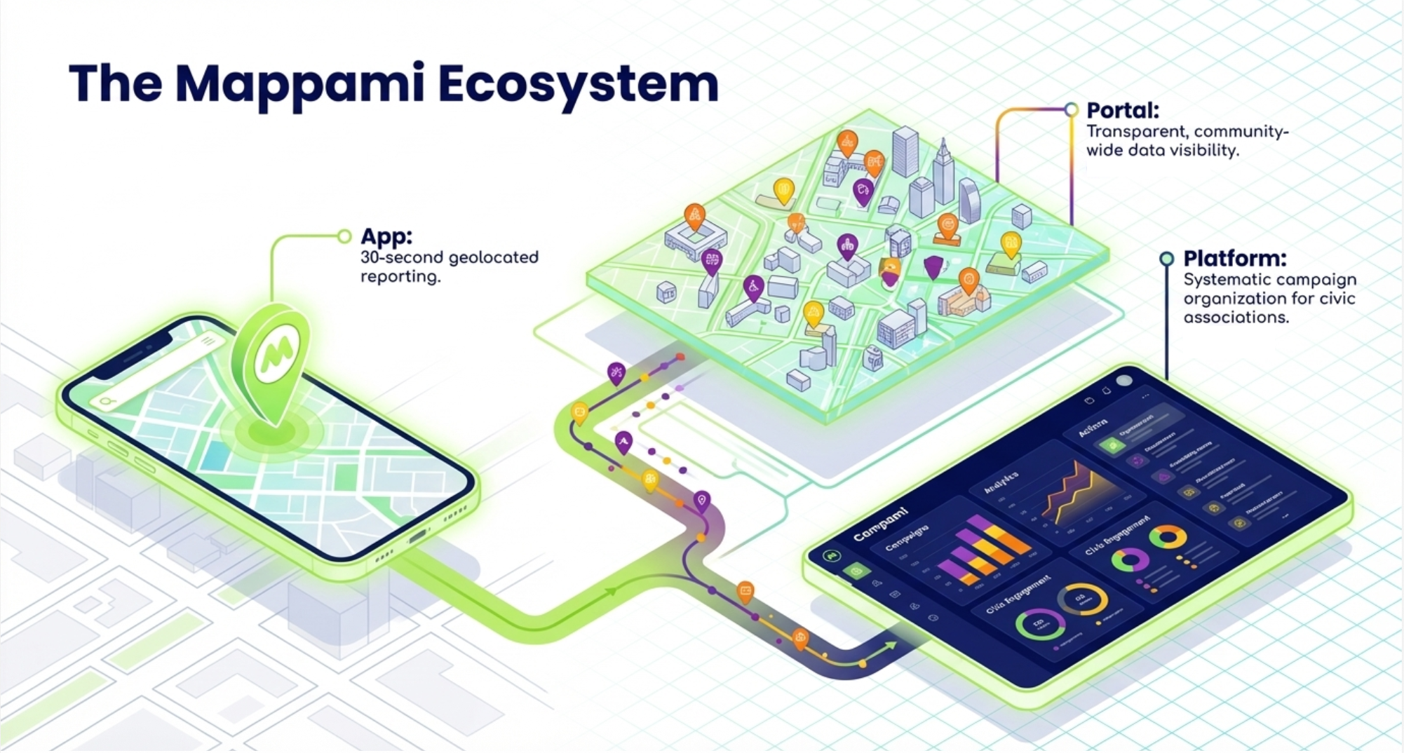
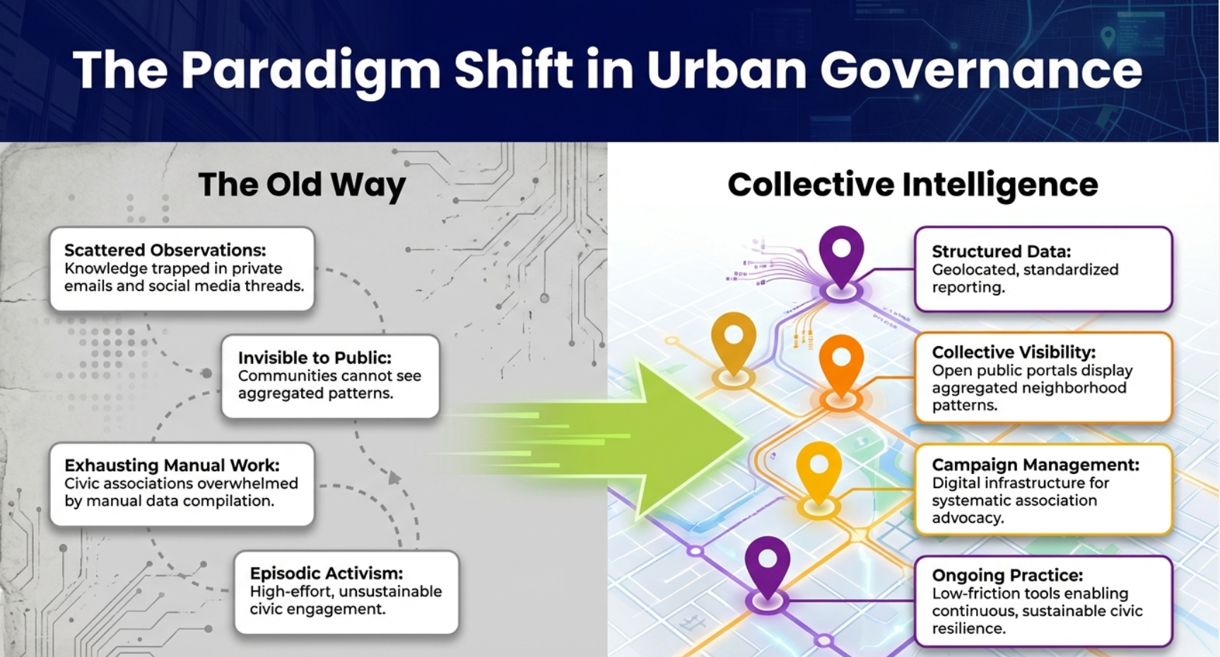
CrowdMap addresses a fundamental challenge in European cities: while residents observe urban issues daily (e.g. broken infrastructure, accessibility barriers, underused spaces)this local knowledge remains scattered and invisible. This fragmentation weakens civic dialogue and leaves communities and institutions working with incomplete territorial information. Our concept transforms scattered observations into structured collective knowledge through three interconnected platforms: a mobile app enabling 30-second geolocated reporting; a public web portal displaying aggregated data through interactive maps; and a management platform allowing civic associations to organize systematic campaigns.
Primary beneficiaries include active citizens seeking to make territorial knowledge visible, civic associations needing digital infrastructure for advocacy, and local administrations wanting evidence-based community input. The concept particularly benefits marginalized voices( elderly, disabled, periphery residents). through accessible participation tools.
Building on a prototype developed through European Solidarity Corps (project n. 2024-3-IT03-ESC30-SOL-000272760) funding, we've achieved validation in Rome's Municipio XII: 100+ active users, working app "Mappami" published on major stores, partnership with civic association Monteverde Attiva, and real campaigns producing 100+ geolocated reports on accessibility, green space, and infrastructure.
What makes this transformative is the integration: unlike complaint apps channeling individual grievances to authorities, CrowdMap creates collective intelligence visible to everyone, shifting power by making community knowledge a shared resource rather than institutional property. The NEB prize enables both completing the integrated ecosystem(developing the public web portal and management platform complementing the existing app)and creating a replicable European model through comprehensive toolkit and cross-border validation.
Primary beneficiaries include active citizens seeking to make territorial knowledge visible, civic associations needing digital infrastructure for advocacy, and local administrations wanting evidence-based community input. The concept particularly benefits marginalized voices( elderly, disabled, periphery residents). through accessible participation tools.
Building on a prototype developed through European Solidarity Corps (project n. 2024-3-IT03-ESC30-SOL-000272760) funding, we've achieved validation in Rome's Municipio XII: 100+ active users, working app "Mappami" published on major stores, partnership with civic association Monteverde Attiva, and real campaigns producing 100+ geolocated reports on accessibility, green space, and infrastructure.
What makes this transformative is the integration: unlike complaint apps channeling individual grievances to authorities, CrowdMap creates collective intelligence visible to everyone, shifting power by making community knowledge a shared resource rather than institutional property. The NEB prize enables both completing the integrated ecosystem(developing the public web portal and management platform complementing the existing app)and creating a replicable European model through comprehensive toolkit and cross-border validation.
The idea emerged in 2023 while volunteering with Monteverde Attiva, a Rome neighborhood association. We witnessed their struggle capturing community knowledge: residents reported issues via scattered channels like email and social media,creating insights that remained disorganized and eventually lost. Manual compilation for municipal dialogue was exhausting and didn't scale.
We secured Solidarity Project (ESC30) funding and launched development in May 2025. Our multidisciplinary team combined technical development, communication strategy, legal expertise, and community engagement skills. Decision-making involved continuous dialogue between our technical team, association coordinators, and early user testers, using collaborative tools like Trello for task management and iterative prototyping with Figma for interface design.
Development proceeded through distinct phases. Initial months focused on community listening: structured interviews revealed existing civic tech failed from excessive complexity. Association leaders co-designed the category taxonomy through facilitated workshops, ensuring classifications reflected actual territorial priorities rather than assumptions.Beta testing with residents producing real reports exposed critical usability issues, particularly around photo upload and geolocation accuracy. The app published on both major platforms in autumn 2025.
Since launch, we've organized three participatory mapping workshops combining methodology training with hands-on practice. 100+ active users have contributed approximately 100 geolocated reports. Monteverde Attiva uses the app regularly for campaigns, and we maintain periodic dialogue with Municipio XII administration. One public event showcased preliminary findings.
Future steps include completing the digital ecosystem (web portal and management platform) and scaling CrowdMap into a replicable European model by creating a toolkit for adoption in new territories.
We secured Solidarity Project (ESC30) funding and launched development in May 2025. Our multidisciplinary team combined technical development, communication strategy, legal expertise, and community engagement skills. Decision-making involved continuous dialogue between our technical team, association coordinators, and early user testers, using collaborative tools like Trello for task management and iterative prototyping with Figma for interface design.
Development proceeded through distinct phases. Initial months focused on community listening: structured interviews revealed existing civic tech failed from excessive complexity. Association leaders co-designed the category taxonomy through facilitated workshops, ensuring classifications reflected actual territorial priorities rather than assumptions.Beta testing with residents producing real reports exposed critical usability issues, particularly around photo upload and geolocation accuracy. The app published on both major platforms in autumn 2025.
Since launch, we've organized three participatory mapping workshops combining methodology training with hands-on practice. 100+ active users have contributed approximately 100 geolocated reports. Monteverde Attiva uses the app regularly for campaigns, and we maintain periodic dialogue with Municipio XII administration. One public event showcased preliminary findings.
Future steps include completing the digital ecosystem (web portal and management platform) and scaling CrowdMap into a replicable European model by creating a toolkit for adoption in new territories.
participatory democracy
citizen empowerment
community co-design
digital inclusion
territorial knowledge
CrowdMap addresses sustainability by transforming civic engagement from resource-intensive episodic actions into efficient ongoing practice, creating durable community capacity across environmental, social, and economic dimensions. Our sustainability objectives target long-term civic resilience: environmentally, enabling data-driven community advocacy on urban ecology; socially, building participatory skills that persist beyond single campaigns; economically, proving democratic tools can operate affordably within existing civic budgets; culturally, strengthening local identity through shared territorial knowledge.
Concrete implementation strategies include digital-first workflows. The platform's architecture prioritizes data permanence: geolocated reports create lasting territorial records useful for multi-year environmental monitoring. Workshop methodology teaches transferable skills(participants trained now conduct independent mapping campaigns). Evidence of achieved sustainability appears in autonomous continuation: associations managing campaigns independently six months post-training; citizens reporting consistently without promotional pushes; operational costs remaining minimum. The distributed participation model means platform viability doesn't depend on centralized coordination or individual champions, critical for long-term durability.What makes this exemplary is the regenerative logic, CrowdMap generates civic capacity that compounds. Each mapping campaign builds community expertise in participatory methods. Each dataset adds to collective territorial intelligence.
The platform creates the conditions for communities to address sustainability challenges—environmental, social, and economic—continuously, moving beyond an approach based on episodic activism that is hard to maintain over time and requires extraordinary effort.
Concrete implementation strategies include digital-first workflows. The platform's architecture prioritizes data permanence: geolocated reports create lasting territorial records useful for multi-year environmental monitoring. Workshop methodology teaches transferable skills(participants trained now conduct independent mapping campaigns). Evidence of achieved sustainability appears in autonomous continuation: associations managing campaigns independently six months post-training; citizens reporting consistently without promotional pushes; operational costs remaining minimum. The distributed participation model means platform viability doesn't depend on centralized coordination or individual champions, critical for long-term durability.What makes this exemplary is the regenerative logic, CrowdMap generates civic capacity that compounds. Each mapping campaign builds community expertise in participatory methods. Each dataset adds to collective territorial intelligence.
The platform creates the conditions for communities to address sustainability challenges—environmental, social, and economic—continuously, moving beyond an approach based on episodic activism that is hard to maintain over time and requires extraordinary effort.
CrowdMap enhances quality of life by transforming civic participation from frustrating invisibility into visible collective action. When residents observe
urban problems daily but lack means to document them effectively, this creates powerlessness degrading experience of place. Our platform makes individual observations visible as collective knowledge, restoring agency and connection to territory.
Implementation integrates design and visual documentation. Interface underwent iterative community refinement through user testing, reducing reporting to minimal cognitive load. Residents become visual documentarians: the reports include citizen-generated photography capturing neighborhood conditions through lived perspective.
Quality of experience centers on empowerment and sensory engagement. While the platform organizes data visually, the act of reporting pushes citizens to physically explore their surroundings, awakening all five senses. Users become active observers of their environment: listening to urban noise, feeling the texture of degraded public spaces, or noticing the air quality and smells of their neighborhood. Reporting creates satisfaction through immediate visible action, validating these multi-sensory personal observations within broader community patterns.
Cultural benefits emerge as shared knowledge becomes community identity. Residents build collective memory through documented observations over time. Aggregated data represents authentic local expression: what this community notices, values, prioritizes, creating distinctive neighborhood identity.
Exemplary character lies in democratizing territorial representation. CrowdMap demonstrates communities can author their own neighborhood portrait—aesthetically valuable because authentic, participatory, dignifying ordinary residents as knowledge creators.
urban problems daily but lack means to document them effectively, this creates powerlessness degrading experience of place. Our platform makes individual observations visible as collective knowledge, restoring agency and connection to territory.
Implementation integrates design and visual documentation. Interface underwent iterative community refinement through user testing, reducing reporting to minimal cognitive load. Residents become visual documentarians: the reports include citizen-generated photography capturing neighborhood conditions through lived perspective.
Quality of experience centers on empowerment and sensory engagement. While the platform organizes data visually, the act of reporting pushes citizens to physically explore their surroundings, awakening all five senses. Users become active observers of their environment: listening to urban noise, feeling the texture of degraded public spaces, or noticing the air quality and smells of their neighborhood. Reporting creates satisfaction through immediate visible action, validating these multi-sensory personal observations within broader community patterns.
Cultural benefits emerge as shared knowledge becomes community identity. Residents build collective memory through documented observations over time. Aggregated data represents authentic local expression: what this community notices, values, prioritizes, creating distinctive neighborhood identity.
Exemplary character lies in democratizing territorial representation. CrowdMap demonstrates communities can author their own neighborhood portrait—aesthetically valuable because authentic, participatory, dignifying ordinary residents as knowledge creators.
CrowdMap addresses inclusion across accessibility, affordability, and governance dimensions, ensuring civic participation serves entire community rather than only digitally privileged populations.
Our inclusion objectives target multiple barriers. Technically, universal usability across age groups and digital literacy levels. Economically, zero cost for citizens and minimal expenses for organizations. Spatially, enabling periphery voices often excluded. Governance-wise, communities own their data rather than institutions extracting information.
Implementation centered on radical simplification. User testing with diverse participants, including elderly residents with limited smartphone experience, drove iterative refinement until reporting required under thirty seconds. Photo-first, text-optional design accommodates varying literacy. Workshops provide alternative participation: facilitators assist non-digital users, ensuring technology bridges rather than barriers.
Three workshops deliberately recruited across age spectrum, creating intergenerational learning where younger participants provide technical support while gaining territorial knowledge. Open-source architecture ensures affordability: citizens participate free, organizations deploy with minimal annual costs.
Results demonstrate inclusion in practice. Workshop participants ranged from early twenties to seventies with continued cross-age engagement. Associations with minimal technical capacity successfully adopted the platform. Reports document marginalized issues: accessibility barriers, periphery infrastructure gaps, making invisible challenges visible.
Exemplary character lies in designing for inclusion from start. Most civic tech builds for tech-savvy users then struggles with broader adoption. CrowdMap inverted this: radical simplification tested with least digitally confident users first, ensuring core accessibility before adding complexity.
Our inclusion objectives target multiple barriers. Technically, universal usability across age groups and digital literacy levels. Economically, zero cost for citizens and minimal expenses for organizations. Spatially, enabling periphery voices often excluded. Governance-wise, communities own their data rather than institutions extracting information.
Implementation centered on radical simplification. User testing with diverse participants, including elderly residents with limited smartphone experience, drove iterative refinement until reporting required under thirty seconds. Photo-first, text-optional design accommodates varying literacy. Workshops provide alternative participation: facilitators assist non-digital users, ensuring technology bridges rather than barriers.
Three workshops deliberately recruited across age spectrum, creating intergenerational learning where younger participants provide technical support while gaining territorial knowledge. Open-source architecture ensures affordability: citizens participate free, organizations deploy with minimal annual costs.
Results demonstrate inclusion in practice. Workshop participants ranged from early twenties to seventies with continued cross-age engagement. Associations with minimal technical capacity successfully adopted the platform. Reports document marginalized issues: accessibility barriers, periphery infrastructure gaps, making invisible challenges visible.
Exemplary character lies in designing for inclusion from start. Most civic tech builds for tech-savvy users then struggles with broader adoption. CrowdMap inverted this: radical simplification tested with least digitally confident users first, ensuring core accessibility before adding complexity.
Participation is foundational to CrowdMap: citizens co-create territorial knowledge rather than providing input to predetermined project.
Beneficiaries include active citizens seeking visibility tools, civic associations needing digital infrastructure, and local administration wanting structured community input. Entire neighborhood benefits from improved civic dialogue and data-informed interventions.
Participation began during prototype development. Structured interviews with association members and residents identified why existing civic tech failed: excessive complexity prevented adoption. This feedback shaped our core principle of radical simplification. Association leaders co-designed category taxonomy through facilitated sessions, ensuring classifications reflected actual priorities rather than our assumptions.
Beta testing with residents producing real reports exposed critical usability issues we'd never caught in isolation. Their influence was decisive: we simplified reporting from multi-screen process to under thirty seconds based on watching users struggle with initial complexity.
Three workshops combined training with hands-on practice. Participants shaped how the tool is used: discussions identified new applications and patterns we hadn't anticipated. Monteverde Attiva's regular adoption means ongoing feedback continuously informs evolution.
Participation improved quality fundamentally. Technical team alone would have built overly complex tool. User involvement drove simplification making adoption possible. Association co-design ensured categories match real civic work. Continuous feedback from users reveals which features matter versus theoretical nice-to-haves.
Most critically, participatory approach validates the concept's democratic purpose: if we can't involve community meaningfully in building participation tool, the tool itself fails its mission.
Beneficiaries include active citizens seeking visibility tools, civic associations needing digital infrastructure, and local administration wanting structured community input. Entire neighborhood benefits from improved civic dialogue and data-informed interventions.
Participation began during prototype development. Structured interviews with association members and residents identified why existing civic tech failed: excessive complexity prevented adoption. This feedback shaped our core principle of radical simplification. Association leaders co-designed category taxonomy through facilitated sessions, ensuring classifications reflected actual priorities rather than our assumptions.
Beta testing with residents producing real reports exposed critical usability issues we'd never caught in isolation. Their influence was decisive: we simplified reporting from multi-screen process to under thirty seconds based on watching users struggle with initial complexity.
Three workshops combined training with hands-on practice. Participants shaped how the tool is used: discussions identified new applications and patterns we hadn't anticipated. Monteverde Attiva's regular adoption means ongoing feedback continuously informs evolution.
Participation improved quality fundamentally. Technical team alone would have built overly complex tool. User involvement drove simplification making adoption possible. Association co-design ensured categories match real civic work. Continuous feedback from users reveals which features matter versus theoretical nice-to-haves.
Most critically, participatory approach validates the concept's democratic purpose: if we can't involve community meaningfully in building participation tool, the tool itself fails its mission.
CrowdMap creates value by connecting stakeholders across governance levels.
Local level involves citizens creating data through daily observations while civic associations like Monteverde Attiva organize campaigns and moderate content. Several territorial associations collaborate actively, using the platform for structured advocacy. This hyperlocal engagement produces detailed territorial knowledge impossible for institutions to gather independently.
Municipal level includes Municipio XII administration with periodic contact. They receive aggregated community data representing priorities expressed through citizen documentation rather than assumptions. Added value for administration is structured, geolocated, quantified input requiring minimal processing for planning decisions.
Regional level engagement includes potential Lazio support. Regional agencies increasingly recognize civic innovation value for addressing participation deficits across municipalities. Other Lazio municipalities observing Rome pilot represent potential adopters.
National connections include civic tech networks and academic researchers studying datas from these participatory processes. Cross-municipal learning adds value through comparative analysis and shared knowledge.
European level centers on NEB community as peer network. We aim to present at civic tech conferences, establish partnerships with pilot cities testing transferability across different countries, and contribute to NEB practice community.
Validation across diverse contexts proves genuine transferability. Network effects mean faster improvement.
Multi-level engagement creates vertical dialogue: neighborhood data informs municipal planning, municipal experience informs regional policy, European network enriches local practice. This vertical integration represents democratic architecture: citizen voice reaching institutional levels typically inaccessible.
Local level involves citizens creating data through daily observations while civic associations like Monteverde Attiva organize campaigns and moderate content. Several territorial associations collaborate actively, using the platform for structured advocacy. This hyperlocal engagement produces detailed territorial knowledge impossible for institutions to gather independently.
Municipal level includes Municipio XII administration with periodic contact. They receive aggregated community data representing priorities expressed through citizen documentation rather than assumptions. Added value for administration is structured, geolocated, quantified input requiring minimal processing for planning decisions.
Regional level engagement includes potential Lazio support. Regional agencies increasingly recognize civic innovation value for addressing participation deficits across municipalities. Other Lazio municipalities observing Rome pilot represent potential adopters.
National connections include civic tech networks and academic researchers studying datas from these participatory processes. Cross-municipal learning adds value through comparative analysis and shared knowledge.
European level centers on NEB community as peer network. We aim to present at civic tech conferences, establish partnerships with pilot cities testing transferability across different countries, and contribute to NEB practice community.
Validation across diverse contexts proves genuine transferability. Network effects mean faster improvement.
Multi-level engagement creates vertical dialogue: neighborhood data informs municipal planning, municipal experience informs regional policy, European network enriches local practice. This vertical integration represents democratic architecture: citizen voice reaching institutional levels typically inaccessible.
CrowdMap integrates diverse knowledge fields, demonstrating that democratic innovation requires transdisciplinary collaboration.
Core disciplines include software engineering for development, UX/UI design for interface simplification, project management for coordination, legal expertise for GDPR compliance and institutional relations, communication strategy for engagement, and geographic information systems for spatial data. Beyond technical fields, we integrate social sciences understanding civic participation, urban planning knowledge, and community organizing principles from association partners.
Collaboration organized through weekly team meetings where developers, designers, legal advisor, and communication specialists review progress jointly. Critical decisions require multiple perspectives: category taxonomy involved technical feasibility, legal data protection, and association civic relevance validation simultaneously.
Coach bridges technical and civic dimensions. GIS expertise informs spatial architecture while startup experience guides sustainability planning. Monthly sessions integrate code review with strategic development.
Different perspectives combined through iterative problem-solving. Beta testing usability issues required designer simplifying interface, developer implementing changes, and organizer validating with users. Legal considerations shaped technical architecture: GDPR requirements influenced database design and photo workflows.
Workshops exemplify transdisciplinary practice: facilitation draws on non-formal education, content addresses urban planning, execution uses digital tools, outcomes serve civic advocacy. Participants contribute territorial knowledge professionals lack.
Added value appears in solutions no single discipline could produce. Integration creates platform simultaneously technically robust, legally compliant, civically relevant, and genuinely usable.
Core disciplines include software engineering for development, UX/UI design for interface simplification, project management for coordination, legal expertise for GDPR compliance and institutional relations, communication strategy for engagement, and geographic information systems for spatial data. Beyond technical fields, we integrate social sciences understanding civic participation, urban planning knowledge, and community organizing principles from association partners.
Collaboration organized through weekly team meetings where developers, designers, legal advisor, and communication specialists review progress jointly. Critical decisions require multiple perspectives: category taxonomy involved technical feasibility, legal data protection, and association civic relevance validation simultaneously.
Coach bridges technical and civic dimensions. GIS expertise informs spatial architecture while startup experience guides sustainability planning. Monthly sessions integrate code review with strategic development.
Different perspectives combined through iterative problem-solving. Beta testing usability issues required designer simplifying interface, developer implementing changes, and organizer validating with users. Legal considerations shaped technical architecture: GDPR requirements influenced database design and photo workflows.
Workshops exemplify transdisciplinary practice: facilitation draws on non-formal education, content addresses urban planning, execution uses digital tools, outcomes serve civic advocacy. Participants contribute territorial knowledge professionals lack.
Added value appears in solutions no single discipline could produce. Integration creates platform simultaneously technically robust, legally compliant, civically relevant, and genuinely usable.
CrowdMap's financial sustainability prioritizes accessibility, proving democratic innovation can operate affordably within civic budgets. Current financing comes from ESC grant covering prototype development and pilot. NEB prize would fund completing the integrated ecosystem and replication methodology. Regional grant application pending could support expanded Rome implementation. Public sources align with civic mission: democratic infrastructure shouldn't depend on commercial revenue.
The project generates no revenues currently. Citizen participation remains free. Future revenue potential exists through optional services: associations or municipalities needing advanced features could access premium tools at accessible rates. White label versions for other cities represent potential income. However, core functionality stays permanently free ensuring universal access.
Implementation costs remain intentionally minimal. The ESC funding of approximately €10k enabled the implementation of a 12-month project, a complete prototype, 6 events, and a 6 month pilot phase. Annual operational costs total under 400 euros for hosting, maintenance, and app store fees. This affordability is strategic: wealthy only access reproduces inequalities.The model contributes to scalability through distributed ownership. Open-source code means cities deploy independently without licensing fees. Minimal costs fit small association budgets. Replication toolkit enables adoption without consulting dependency. This creates network sustainability: adopters share development improvements while maintaining local autonomy. Disruptive potential lies in proving civic participation infrastructure need not be expensive commercial product. Current market assumes either costly vendor solutions or unsustainable volunteer efforts. CrowdMap demonstrates third path: professional-quality tools operating affordably through smart design, collaboration, and public funding aligned with democratic purpose.
The project generates no revenues currently. Citizen participation remains free. Future revenue potential exists through optional services: associations or municipalities needing advanced features could access premium tools at accessible rates. White label versions for other cities represent potential income. However, core functionality stays permanently free ensuring universal access.
Implementation costs remain intentionally minimal. The ESC funding of approximately €10k enabled the implementation of a 12-month project, a complete prototype, 6 events, and a 6 month pilot phase. Annual operational costs total under 400 euros for hosting, maintenance, and app store fees. This affordability is strategic: wealthy only access reproduces inequalities.The model contributes to scalability through distributed ownership. Open-source code means cities deploy independently without licensing fees. Minimal costs fit small association budgets. Replication toolkit enables adoption without consulting dependency. This creates network sustainability: adopters share development improvements while maintaining local autonomy. Disruptive potential lies in proving civic participation infrastructure need not be expensive commercial product. Current market assumes either costly vendor solutions or unsustainable volunteer efforts. CrowdMap demonstrates third path: professional-quality tools operating affordably through smart design, collaboration, and public funding aligned with democratic purpose.
CrowdMap's design prioritizes transferability: methodology, technology, and learnings structured for replication across diverse European contexts.
The concept serves as model because it addresses universal challenge: fragmented civic knowledge exists everywhere, but few cities have affordable tools to structure it. Our Rome pilot demonstrates viability in typical mid-sized urban context without exceptional resources, proving transferability to similar settings. Most transferable elements include complete documentation, workshop methodology through facilitation guides and videos, adaptable category taxonomy, and minimal-cost operational model fitting any municipal budget. Technical architecture uses standard web technologies avoiding proprietary dependencies. Implementation requires basic skills: web hosting setup, community facilitation, and local civic network for initial adoption. No specialized technical expertise beyond standard IT administration. Partnerships with existing civic associations prove essential: our Monteverde Attiva collaboration demonstrates how established organizations provide community credibility new platforms alone cannot generate. Adaptation needs vary by context. Urban density affects focus: dense cities prioritize infrastructure, sprawling areas emphasize accessibility. Civic culture matters: strong associational contexts leverage management platform immediately, weaker sectors start with citizen app building grassroots first. Municipal capacity varies: tech-capable administrations integrate data directly, others receive periodic reports. Categories must reflect local priorities. Key transferable learnings include radical simplification proving essential for adoption, association partnership critical for legitimacy, iterative user testing preventing complexity, and photo-first documentation working across literacy levels. Workshop model combining training with immediate practice proves effective across cultures.
The concept serves as model because it addresses universal challenge: fragmented civic knowledge exists everywhere, but few cities have affordable tools to structure it. Our Rome pilot demonstrates viability in typical mid-sized urban context without exceptional resources, proving transferability to similar settings. Most transferable elements include complete documentation, workshop methodology through facilitation guides and videos, adaptable category taxonomy, and minimal-cost operational model fitting any municipal budget. Technical architecture uses standard web technologies avoiding proprietary dependencies. Implementation requires basic skills: web hosting setup, community facilitation, and local civic network for initial adoption. No specialized technical expertise beyond standard IT administration. Partnerships with existing civic associations prove essential: our Monteverde Attiva collaboration demonstrates how established organizations provide community credibility new platforms alone cannot generate. Adaptation needs vary by context. Urban density affects focus: dense cities prioritize infrastructure, sprawling areas emphasize accessibility. Civic culture matters: strong associational contexts leverage management platform immediately, weaker sectors start with citizen app building grassroots first. Municipal capacity varies: tech-capable administrations integrate data directly, others receive periodic reports. Categories must reflect local priorities. Key transferable learnings include radical simplification proving essential for adoption, association partnership critical for legitimacy, iterative user testing preventing complexity, and photo-first documentation working across literacy levels. Workshop model combining training with immediate practice proves effective across cultures.
Development plan covers first year (May 2026 - April 2027), building on completed ESC prototype to create integrated replicable ecosystem.
Months 1-4 focus on completing platform development. Public web portal development enables community-wide data visibility through interactive maps and filtering. Management platform provides associations with campaign tools and moderation workflows. Lean development approach: core features tested with Rome users, iterated based on feedback. Technical specifications draw from ESC lessons learned.
Months 3-6 expand community validation. Two workshops train new participants and test enhanced functionality. Monteverde Attiva and partner associations pilot management platform through real campaigns, providing usage feedback. Public event presents integrated ecosystem to wider audience including potential adopters.
Months 5-9 create replication toolkit. Implementation guide documents technical setup workshop methodologies, and cost models across different budget scenarios. Video tutorials demonstrate deployment and facilitation. Case studies analyze Rome pilot with concrete data on successes and challenges encountered.
Months 7-10 prepare European transfer. Outreach to potential pilot cities explores adaptation needs. Presentations at civic tech conferences introduce methodology to EU practitioners.
Months 9-12 validate transferability. Support pilot city implementation using only toolkit resources, documenting challenges and necessary adaptations. Gather feedback informing toolkit revisions. Integration with NEB community if selected, otherwise civic tech networks.
Expected results include three operational platforms in Rome, continued user engagement building on ESC base, complete replication toolkit published, open-source release, pilot city partnership explored, and methodology validated for transfer. Additional funding would accelerate development.
Months 1-4 focus on completing platform development. Public web portal development enables community-wide data visibility through interactive maps and filtering. Management platform provides associations with campaign tools and moderation workflows. Lean development approach: core features tested with Rome users, iterated based on feedback. Technical specifications draw from ESC lessons learned.
Months 3-6 expand community validation. Two workshops train new participants and test enhanced functionality. Monteverde Attiva and partner associations pilot management platform through real campaigns, providing usage feedback. Public event presents integrated ecosystem to wider audience including potential adopters.
Months 5-9 create replication toolkit. Implementation guide documents technical setup workshop methodologies, and cost models across different budget scenarios. Video tutorials demonstrate deployment and facilitation. Case studies analyze Rome pilot with concrete data on successes and challenges encountered.
Months 7-10 prepare European transfer. Outreach to potential pilot cities explores adaptation needs. Presentations at civic tech conferences introduce methodology to EU practitioners.
Months 9-12 validate transferability. Support pilot city implementation using only toolkit resources, documenting challenges and necessary adaptations. Gather feedback informing toolkit revisions. Integration with NEB community if selected, otherwise civic tech networks.
Expected results include three operational platforms in Rome, continued user engagement building on ESC base, complete replication toolkit published, open-source release, pilot city partnership explored, and methodology validated for transfer. Additional funding would accelerate development.