Arts, Culture, and Heritage as Drivers of Change
Story of a stream
Caring for hidden waters to regenerate landscapes, architectures, human and non-human living systems
The heart of the concept lies in a territorial stewardship strategy in Nailloux, based on its geography and network of hidden streams. By caring for silent resources, it restores hydrological, ecological and social continuity, strengthens landscapes and their architectures, culture heritage and fosters social cohesion. Experimental pilot sites, from cooperative housing to a productive food area, illustrate a regenerative approach supporting resilient societies and sustainable living over time.
France
Local
Nailloux (31)
Mainly rural
It involves a physical transformation of the built environment (hard investment)
Early concept
No
No
Yes
Individual
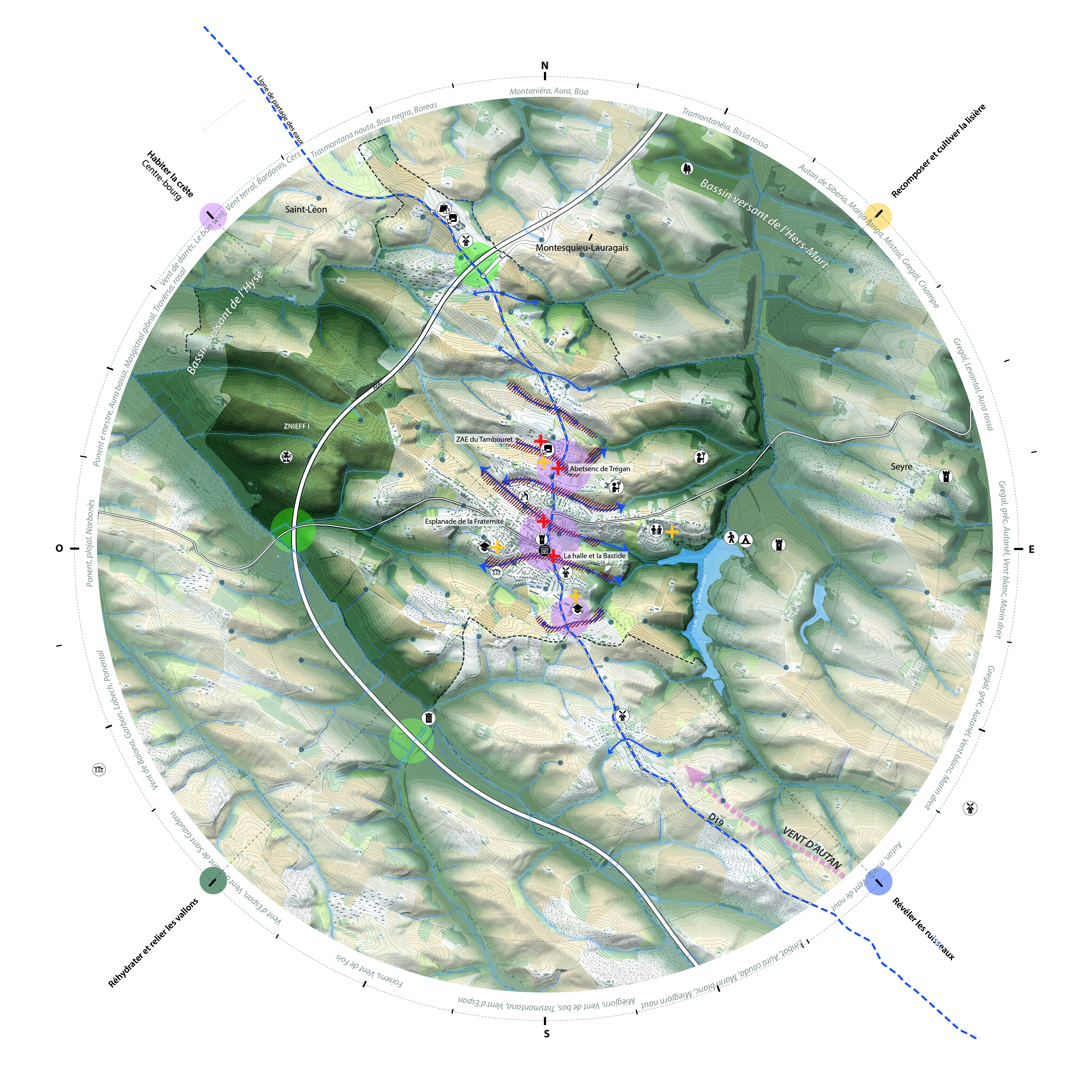
Nailloux is a rural town in the Lauragais region, located on a ridge between the Hyse and Hers-Mort watersheds. Its territory, shaped by cereal farming, fragile geology and the Autan wind, is structured by a discreet network of streams that originate on the ridge and flow into the valleys. Although it has a strong rural identity, the commune is now undergoing peri-urban dynamics linked to its connection to Toulouse via the A66 motorway and is increasingly exposed to climate risks such as droughts.
The concept, proposed as part of the Europan ideas competition, proposes a territorial strategy based on the geography and activation of silent resources ; living soils, hidden waters and local know-how, drawing on the environments that make up Nailloux.
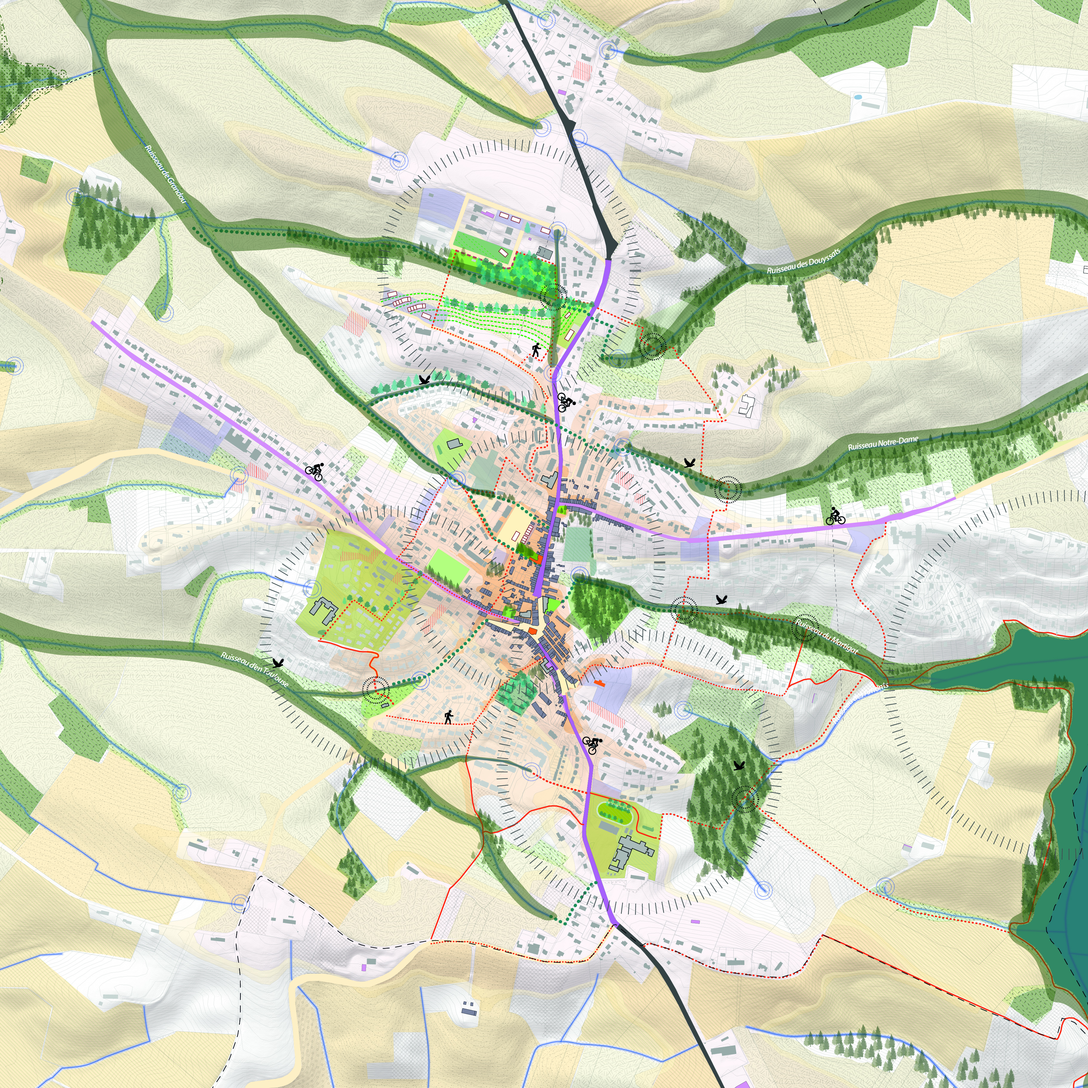
On the ridge, gentle densification and the rehabilitation of built heritage help limit urban sprawl while reinforcing proximity and everyday uses in the village.
The edges become fertile transitional spaces between town and countryside, accommodating gardens, communal vegetable gardens and shared spaces that strengthen social ties and local rootedness.
The valleys are preserved and rehydrated in order to restore ecological and hydraulic continuity and support agriculture based on regenerative hydrology.
A network of soft mobility reconnects these environments and links everyday destinations across the territory.
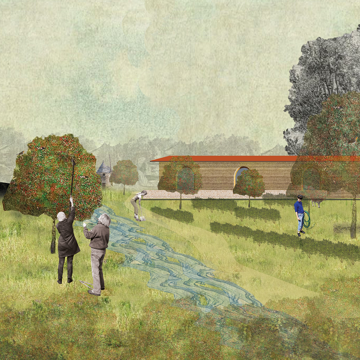
Experimental pilot sites illustrate this strategy, such as a cooperative housing project in the village or a productive gateway combining local food production, economic activities and housing.
The streams running through these environments becomes the infrastructure guiding the project. By revealing and slowing down the water network, the project improves soil water retention, strengthens biodiversity and mitigates the effects of droughts.
Ultimately, this territorial strategy aims to limit land artificialisation, preserve natural resources and support more resource-efficient and resilient ways of living.
The concept, proposed as part of the Europan ideas competition, proposes a territorial strategy based on the geography and activation of silent resources ; living soils, hidden waters and local know-how, drawing on the environments that make up Nailloux.
On the ridge, gentle densification and the rehabilitation of built heritage help limit urban sprawl while reinforcing proximity and everyday uses in the village.
The edges become fertile transitional spaces between town and countryside, accommodating gardens, communal vegetable gardens and shared spaces that strengthen social ties and local rootedness.
The valleys are preserved and rehydrated in order to restore ecological and hydraulic continuity and support agriculture based on regenerative hydrology.
A network of soft mobility reconnects these environments and links everyday destinations across the territory.
Experimental pilot sites illustrate this strategy, such as a cooperative housing project in the village or a productive gateway combining local food production, economic activities and housing.
The streams running through these environments becomes the infrastructure guiding the project. By revealing and slowing down the water network, the project improves soil water retention, strengthens biodiversity and mitigates the effects of droughts.
Ultimately, this territorial strategy aims to limit land artificialisation, preserve natural resources and support more resource-efficient and resilient ways of living.
The initial commission for the Europan architecture and urbanism ideas competition in Nailloux focused on the transformation of two main sites within the municipality. Rather than treating these places in isolation, they were considered as entry points for a broader territorial reflection.
The work began with a careful reading of the territory, based on the analysis of geography and topography, as well as agricultural landscapes, ecological continuities and built heritage. Through the mapping of environments and hydrological dynamics, a structuring element gradually emerged: the discreet network of streams crossing the territory, revealing both climate challenges and broader environmental issues.
These often invisible water flows also became the guiding thread of the project, suggesting that the transformation of landscapes and urban spaces could be conceived in relation to the hydrological system shaping the territory.
Instead of proposing urban and architectural interventions solely on the plots identified by the municipality, the aim was to develop a territorial stewardship strategy in which pilot sites become testing grounds to explore new relationships between inhabited urban fabrics, agriculture and natural environments. The territory was therefore interpreted as a system of complementary spaces whose geographical and ecological characteristics guide possibilities for transformation.
The project is conceived as a gradual transformation of the territory, combining spatial interventions, adaptation of uses and the mobilisation of local actors.
The project therefore proposes to accompany territorial dynamics over time through short-, medium- and long-term actions that combine operational interventions and forward-looking reflection. It also develops a narrative for rural and peri-urban territories toward 2100, where human settlements and living systems are understood as interdependent.
The work began with a careful reading of the territory, based on the analysis of geography and topography, as well as agricultural landscapes, ecological continuities and built heritage. Through the mapping of environments and hydrological dynamics, a structuring element gradually emerged: the discreet network of streams crossing the territory, revealing both climate challenges and broader environmental issues.
These often invisible water flows also became the guiding thread of the project, suggesting that the transformation of landscapes and urban spaces could be conceived in relation to the hydrological system shaping the territory.
Instead of proposing urban and architectural interventions solely on the plots identified by the municipality, the aim was to develop a territorial stewardship strategy in which pilot sites become testing grounds to explore new relationships between inhabited urban fabrics, agriculture and natural environments. The territory was therefore interpreted as a system of complementary spaces whose geographical and ecological characteristics guide possibilities for transformation.
The project is conceived as a gradual transformation of the territory, combining spatial interventions, adaptation of uses and the mobilisation of local actors.
The project therefore proposes to accompany territorial dynamics over time through short-, medium- and long-term actions that combine operational interventions and forward-looking reflection. It also develops a narrative for rural and peri-urban territories toward 2100, where human settlements and living systems are understood as interdependent.
Re-sourcing
Regenerative landscapes
Water resilience
Natural and cultural heritage
Social connections
As droughts intensify and water resources become scarcer worldwide, rural and peri-urban territories must rethink their development models. In Nailloux, streams structure the landscape but are increasingly threatened by soil sealing and intensive agricultural practices. The project addresses these challenges by placing water and living soils at the centre of territorial transformation, revealing existing resources and restoring ecological and hydrological continuities.
The strategy relies on a geography-based approach and nature-based solutions. On the ridge, the project prioritises the transformation and rehabilitation of built heritage using local materials (earthen construction materials, brick, limestone, timber and agricultural bio-based resources like straw or hemp). In the design of buildings and public spaces, including squares at the junctions of ecological corridors and along the watershed divide, rainwater is either infiltrated into the soil or stored for irrigating community market gardens and local crops. Gentle densification and the reuse of underused land help limit urban sprawl and agricultural land consumption.
At the edges between urban and agricultural areas, spaces of experimentation emerge where neighbourhood commons, food production, biodiversity and collective uses interact, strengthening social ties, local food systems, and everyday practices.
In the valleys, landscapes are progressively rehydrated through the restoration of hedgerows, vegetated swales, micro-retention systems and permeable soils that slow down, infiltrate and store water in the ground. These interventions improve soil water retention, strengthen biodiversity and reduce the combined effects of droughts and floods.
By reconnecting urban development, architecture, agriculture and water cycles, the project proposes a regenerative model for rural and peri-urban territories, supporting long-term climate adaptation while integrating local knowledge and territorial strategies.
The strategy relies on a geography-based approach and nature-based solutions. On the ridge, the project prioritises the transformation and rehabilitation of built heritage using local materials (earthen construction materials, brick, limestone, timber and agricultural bio-based resources like straw or hemp). In the design of buildings and public spaces, including squares at the junctions of ecological corridors and along the watershed divide, rainwater is either infiltrated into the soil or stored for irrigating community market gardens and local crops. Gentle densification and the reuse of underused land help limit urban sprawl and agricultural land consumption.
At the edges between urban and agricultural areas, spaces of experimentation emerge where neighbourhood commons, food production, biodiversity and collective uses interact, strengthening social ties, local food systems, and everyday practices.
In the valleys, landscapes are progressively rehydrated through the restoration of hedgerows, vegetated swales, micro-retention systems and permeable soils that slow down, infiltrate and store water in the ground. These interventions improve soil water retention, strengthen biodiversity and reduce the combined effects of droughts and floods.
By reconnecting urban development, architecture, agriculture and water cycles, the project proposes a regenerative model for rural and peri-urban territories, supporting long-term climate adaptation while integrating local knowledge and territorial strategies.
The project operates across multiple territorial scales to improve the quality of everyday spaces and strengthen the relationship between landscapes, architectures and daily practices.
It contributes to the transformation of welcoming public spaces and meeting places adapted to everyday life. Squares and streets currently dominated by cars are depaved or traffic-calmed to create environments more conducive to encounters, collective activities and daily uses. These transformations give space back to inhabitants and reinforce the convivial character of public spaces.
The project also develops a network of soft mobility linking neighbourhoods, schools, public facilities, shops and surrounding agricultural areas. These pedestrian and cycling paths facilitate everyday mobility while inviting inhabitants to rediscover the territory at a slower pace. Walking, meeting others, contemplating the landscape become ordinary experiences that nurture a more attentive relationship with the place.
Nailloux offers remarkable views over the Lauragais landscapes and the Pyrenees. Through a form of territorial acupuncture, the project reveals and enhances these landscape situations. New paths reconnect previously isolated places, while viewpoints and resting areas strengthen inhabitants’ relationship with the landscape. The project also reinforces a sense of belonging by valuing existing heritage, public facilities and local associations that structure collective life in the municipality.
Beauty also emerges from practices that care for the territory. Community gardens, market gardening and collective spaces reconnect inhabitants with soils and water cycles, fostering a shared culture of stewardship.
Finally, careful attention to landscapes, materials and ecological processes guides both rehabilitation and new constructions, which integrate into the Lauragais landscape of a thousand hills.
It contributes to the transformation of welcoming public spaces and meeting places adapted to everyday life. Squares and streets currently dominated by cars are depaved or traffic-calmed to create environments more conducive to encounters, collective activities and daily uses. These transformations give space back to inhabitants and reinforce the convivial character of public spaces.
The project also develops a network of soft mobility linking neighbourhoods, schools, public facilities, shops and surrounding agricultural areas. These pedestrian and cycling paths facilitate everyday mobility while inviting inhabitants to rediscover the territory at a slower pace. Walking, meeting others, contemplating the landscape become ordinary experiences that nurture a more attentive relationship with the place.
Nailloux offers remarkable views over the Lauragais landscapes and the Pyrenees. Through a form of territorial acupuncture, the project reveals and enhances these landscape situations. New paths reconnect previously isolated places, while viewpoints and resting areas strengthen inhabitants’ relationship with the landscape. The project also reinforces a sense of belonging by valuing existing heritage, public facilities and local associations that structure collective life in the municipality.
Beauty also emerges from practices that care for the territory. Community gardens, market gardening and collective spaces reconnect inhabitants with soils and water cycles, fostering a shared culture of stewardship.
Finally, careful attention to landscapes, materials and ecological processes guides both rehabilitation and new constructions, which integrate into the Lauragais landscape of a thousand hills.
The project aims to strengthen inclusion by acting on accessibility, housing, collective dynamics and local governance. It seeks to facilitate access for all to the territory’s resources ; public spaces, landscapes, facilities and local agriculture, and to promote more solidaristic ways of living.
For example, the project explores forms of cooperative housing inspired by Swiss models. In this system, residents become members of a cooperative that collectively owns the buildings, while the land can be made available by the municipality through long-term leases. This non-speculative model helps reduce housing costs, stabilise rents and encourage the creation of shared spaces ; gardens, workshops and common rooms, that foster exchanges and solidarity between residents.
The development of a network of soft mobility connecting residential neighbourhoods, schools, public facilities, shops and surrounding agricultural areas improves accessibility for everyday activities as well as leisure, while offering alternatives to car dependency. Designed according to accessibility-for-all principles, this network of pedestrian and cycling paths also reconnects places that are currently isolated and opens broader access to landscapes and natural spaces.
Beyond the spatial response proposed by the project, the proposal also promotes an implementation method. It encourages local authorities to initiate a territorial masterplan at short-, medium- and long-term horizons, developed by a multidisciplinary team of architects, urban planners, landscape architects and engineering offices. This masterplan would establish a shared strategic framework, gradually developed with municipal services and residents. Workshops, participatory sessions or exploratory walks could help integrate residents’ voices into decision-making processes. This process helps ensure that territorial transformations respond to local needs while strengthening collective ownership of the project.
For example, the project explores forms of cooperative housing inspired by Swiss models. In this system, residents become members of a cooperative that collectively owns the buildings, while the land can be made available by the municipality through long-term leases. This non-speculative model helps reduce housing costs, stabilise rents and encourage the creation of shared spaces ; gardens, workshops and common rooms, that foster exchanges and solidarity between residents.
The development of a network of soft mobility connecting residential neighbourhoods, schools, public facilities, shops and surrounding agricultural areas improves accessibility for everyday activities as well as leisure, while offering alternatives to car dependency. Designed according to accessibility-for-all principles, this network of pedestrian and cycling paths also reconnects places that are currently isolated and opens broader access to landscapes and natural spaces.
Beyond the spatial response proposed by the project, the proposal also promotes an implementation method. It encourages local authorities to initiate a territorial masterplan at short-, medium- and long-term horizons, developed by a multidisciplinary team of architects, urban planners, landscape architects and engineering offices. This masterplan would establish a shared strategic framework, gradually developed with municipal services and residents. Workshops, participatory sessions or exploratory walks could help integrate residents’ voices into decision-making processes. This process helps ensure that territorial transformations respond to local needs while strengthening collective ownership of the project.
Although the proposal was developed within the framework of the Europan competition, an initial public presentation already enabled a first dialogue with residents and local stakeholders. The winning projects of the Europan competition were presented during a public meeting organised with the municipality. This meeting created an opportunity to exchange with inhabitants and local actors, allowing the discussion of the first ideas and the identification of everyday issues related to the territory.
These exchanges highlighted local concerns and uses of the territory, particularly regarding mobility, public spaces and the relationship between the town and its surrounding agricultural environment. They contributed to enriching the reflection and confirmed several of the territorial dynamics explored in the project.
In this perspective, the proposal does not aim to define a fixed solution. It follows the spirit of the Europan competition, which seeks to open perspectives and stimulate debate about the future of territories. The proposal therefore acts as a starting point intended to be discussed, adapted and further developed during future operational phases.
The project also encourages the development of a territorial plan-guide in the short, medium and long term. This framework would help coordinate future transformations while maintaining a coherent long-term vision. Within this process, residents and local stakeholders could continue to be involved through workshops, participatory sessions or exploratory walks. Particular attention could be given to intergenerational participation by involving both children and older residents in dedicated activities such as storytelling, collective mapping or shared walks, allowing memories, local knowledge and everyday experiences to inform the evolution of the project.
The transformation of the territory is thus conceived as a collective and evolving process shaped together with those who inhabit it.
These exchanges highlighted local concerns and uses of the territory, particularly regarding mobility, public spaces and the relationship between the town and its surrounding agricultural environment. They contributed to enriching the reflection and confirmed several of the territorial dynamics explored in the project.
In this perspective, the proposal does not aim to define a fixed solution. It follows the spirit of the Europan competition, which seeks to open perspectives and stimulate debate about the future of territories. The proposal therefore acts as a starting point intended to be discussed, adapted and further developed during future operational phases.
The project also encourages the development of a territorial plan-guide in the short, medium and long term. This framework would help coordinate future transformations while maintaining a coherent long-term vision. Within this process, residents and local stakeholders could continue to be involved through workshops, participatory sessions or exploratory walks. Particular attention could be given to intergenerational participation by involving both children and older residents in dedicated activities such as storytelling, collective mapping or shared walks, allowing memories, local knowledge and everyday experiences to inform the evolution of the project.
The transformation of the territory is thus conceived as a collective and evolving process shaped together with those who inhabit it.
The project relies on a governance approach articulated across multiple territorial scales, mobilising stakeholders involved in territorial transformation.
At the local level, the municipality of Nailloux plays a central role in implementing development projects, particularly the transformation of public spaces, the requalification of streets and squares, and the evolution of housing. Residents, associations and economic actors also contribute by sharing their everyday uses of the territory and expectations for the living environment.
Mobility policies also involve departmental authorities responsible for redesigning the departmental road to support soft mobility and safer connections between municipalities.
At a broader scale, water management involves stakeholders operating at the watershed level and institutions responsible for hydraulic infrastructures, including the Thésauque lake dam. Their engagement helps coordinate water strategies beyond municipal boundaries and strengthens coherence between land planning, agriculture and water resources.
As agricultural land represents around 50% of the French territory, compared to less than 10% of artificialised land, the dominant agricultural model and food production systems play a major role in shaping landscapes and water cycles. Rethinking agricultural practices in the valleys is therefore essential to support sustainable soil and water management and restore ecological and hydrological continuities. These transitions also require support from national and European policies.
At the national level, the project aligns with the objectives of reducing land artificialisation promoted by the Zero Net Land Take (ZAN) policy. The strategy based on rehabilitation, gentle densification and preservation of agricultural valleys helps translate these objectives into local planning.
Finally, the Europan competition fosters exchanges between municipalities and designers across Europe facing similar territorial challenges.
At the local level, the municipality of Nailloux plays a central role in implementing development projects, particularly the transformation of public spaces, the requalification of streets and squares, and the evolution of housing. Residents, associations and economic actors also contribute by sharing their everyday uses of the territory and expectations for the living environment.
Mobility policies also involve departmental authorities responsible for redesigning the departmental road to support soft mobility and safer connections between municipalities.
At a broader scale, water management involves stakeholders operating at the watershed level and institutions responsible for hydraulic infrastructures, including the Thésauque lake dam. Their engagement helps coordinate water strategies beyond municipal boundaries and strengthens coherence between land planning, agriculture and water resources.
As agricultural land represents around 50% of the French territory, compared to less than 10% of artificialised land, the dominant agricultural model and food production systems play a major role in shaping landscapes and water cycles. Rethinking agricultural practices in the valleys is therefore essential to support sustainable soil and water management and restore ecological and hydrological continuities. These transitions also require support from national and European policies.
At the national level, the project aligns with the objectives of reducing land artificialisation promoted by the Zero Net Land Take (ZAN) policy. The strategy based on rehabilitation, gentle densification and preservation of agricultural valleys helps translate these objectives into local planning.
Finally, the Europan competition fosters exchanges between municipalities and designers across Europe facing similar territorial challenges.
The project is based on a transdisciplinary approach mobilising several fields of knowledge to address territorial transformation in all its complexity. As an architect and urban planner attentive to landscapes, water dynamics and living environments, it connects disciplines to better understand territorial dynamics.
Geography and topography constitute the starting point of the project. Rather than a simple spatial analysis, they reveal the interdependencies between ridges, edges, valleys and streams, as well as relations between human and non-human environments. This perspective highlights how territorial transformations affect water cycles and landscape dynamics. The project title refers to Élisée Reclus’ book "Histoire d’un ruisseau" (1869), in which the geographer follows the course of a stream to observe how water shapes landscapes and invites reflection on the relationship between humans and nature.
History also informs the reading of the territory, helping to understand the evolution of settlement patterns, agricultural systems and development logics that have shaped the Lauragais landscapes and heritage.
Environmental sciences and hydrology contribute to understanding ecological dynamics linking soils, water cycles and living environments, while agriculture plays a key role in shaping soils, biodiversity and productive landscapes.
Social sciences support participatory approaches involving residents and local actors, drawing on everyday practices to inform projects and territorial strategies.
Finally, architecture, urbanism and landscape design shape the project through spatial interventions responding to territorial challenges: construction and rehabilitation, transformation of public and shared spaces, restructuring of economic activity areas, and renewed relations between the village, agricultural landscapes and natural environments, carefully integrated within the topography to improve everyday collective life.
Geography and topography constitute the starting point of the project. Rather than a simple spatial analysis, they reveal the interdependencies between ridges, edges, valleys and streams, as well as relations between human and non-human environments. This perspective highlights how territorial transformations affect water cycles and landscape dynamics. The project title refers to Élisée Reclus’ book "Histoire d’un ruisseau" (1869), in which the geographer follows the course of a stream to observe how water shapes landscapes and invites reflection on the relationship between humans and nature.
History also informs the reading of the territory, helping to understand the evolution of settlement patterns, agricultural systems and development logics that have shaped the Lauragais landscapes and heritage.
Environmental sciences and hydrology contribute to understanding ecological dynamics linking soils, water cycles and living environments, while agriculture plays a key role in shaping soils, biodiversity and productive landscapes.
Social sciences support participatory approaches involving residents and local actors, drawing on everyday practices to inform projects and territorial strategies.
Finally, architecture, urbanism and landscape design shape the project through spatial interventions responding to territorial challenges: construction and rehabilitation, transformation of public and shared spaces, restructuring of economic activity areas, and renewed relations between the village, agricultural landscapes and natural environments, carefully integrated within the topography to improve everyday collective life.
The project relies on a gradual implementation combining public funding, cooperative initiatives and the development of the local economy to support long-term territorial transformation.
As a first step, the development of a municipal masterplan represents a structuring phase. This study could be led by the municipality of Nailloux with the support of national programmes assisting small towns, such as those coordinated by the ANCT (French National Agency for Territorial Cohesion), as well as public partners involved in land strategies such as EPF (Public Land Establishments). Additional studies could then be carried out on pilot sites identified in the masterplan.
In the village, the project proposes the creation of a housing cooperative. Land could be made available through instruments such as the Real Solidarity Lease (BRS) or long-term leases, while the cooperative would collectively own the buildings. This non-speculative model helps stabilise rents while enabling shared facilities and neighbourhood-oriented activities.
The productive gateway of the city entrance represents another economic lever. The project proposes a food hub combining market gardening, food processing facilities (vegetable processing unit and central kitchen) and multifunctional spaces welcoming local small and medium-sized businesses, craft activities and services. These activities could be carried by cooperatives or social economy organisations, supported by agricultural land tools such as environmental rural leases or land stewardship organisations such as Terre de Liens.
Water management and ecological restoration could involve the Adour-Garonne Water Agency, while ecological transition programmes led by ADEME or European funds such as FEDER/FEADER could support sustainable food systems and landscape restoration.
This approach strengthens local value chains and supports long-term territorial transformation.
As a first step, the development of a municipal masterplan represents a structuring phase. This study could be led by the municipality of Nailloux with the support of national programmes assisting small towns, such as those coordinated by the ANCT (French National Agency for Territorial Cohesion), as well as public partners involved in land strategies such as EPF (Public Land Establishments). Additional studies could then be carried out on pilot sites identified in the masterplan.
In the village, the project proposes the creation of a housing cooperative. Land could be made available through instruments such as the Real Solidarity Lease (BRS) or long-term leases, while the cooperative would collectively own the buildings. This non-speculative model helps stabilise rents while enabling shared facilities and neighbourhood-oriented activities.
The productive gateway of the city entrance represents another economic lever. The project proposes a food hub combining market gardening, food processing facilities (vegetable processing unit and central kitchen) and multifunctional spaces welcoming local small and medium-sized businesses, craft activities and services. These activities could be carried by cooperatives or social economy organisations, supported by agricultural land tools such as environmental rural leases or land stewardship organisations such as Terre de Liens.
Water management and ecological restoration could involve the Adour-Garonne Water Agency, while ecological transition programmes led by ADEME or European funds such as FEDER/FEADER could support sustainable food systems and landscape restoration.
This approach strengthens local value chains and supports long-term territorial transformation.
The challenges addressed by the project extend far beyond the territory of Nailloux. In a context marked by climate emergency, geopolitical tensions and the growing scarcity of resources, the issues of water, soils and food are becoming central at both European and global scales. Rural and suburban territories play a strategic role in these transitions: they concentrate essential resources that also contribute to the balance of urban areas, while being subjected to strong pressures of urbanisation.
In this perspective, the most transferable element of the project lies in the method it proposes. The project is based on a careful reading of geography and environments in order to understand the dynamics that structure the territory. It considers the territory as a project material in which the path of water guides spatial transformations.
This approach also articulates different scales of intervention: each local action contributes to a broader territorial vision. The objective is to move beyond fragmented interventions and embed projects within an overall coherence, where small-scale transformations support a wider territorial strategy grounded in environmental dynamics.
The method can be applied in other contexts without producing a universal model. Each territory has its own resources, landscapes, uses and social dynamics. The challenge is therefore to build upon what already exists (what shapes places and what matters to inhabitants), in order to support transformations adapted to each situation.
The project also seeks to move beyond traditional oppositions between city and countryside by strengthening the relationships between housing, agriculture, landscapes and natural resources.
In the era of the Anthropocene, this approach invites us to rethink how humans interact with living systems and shape territories, developing a more attentive and humble relationship with the environments that make our societies habitable.
In this perspective, the most transferable element of the project lies in the method it proposes. The project is based on a careful reading of geography and environments in order to understand the dynamics that structure the territory. It considers the territory as a project material in which the path of water guides spatial transformations.
This approach also articulates different scales of intervention: each local action contributes to a broader territorial vision. The objective is to move beyond fragmented interventions and embed projects within an overall coherence, where small-scale transformations support a wider territorial strategy grounded in environmental dynamics.
The method can be applied in other contexts without producing a universal model. Each territory has its own resources, landscapes, uses and social dynamics. The challenge is therefore to build upon what already exists (what shapes places and what matters to inhabitants), in order to support transformations adapted to each situation.
The project also seeks to move beyond traditional oppositions between city and countryside by strengthening the relationships between housing, agriculture, landscapes and natural resources.
In the era of the Anthropocene, this approach invites us to rethink how humans interact with living systems and shape territories, developing a more attentive and humble relationship with the environments that make our societies habitable.
The winning projects of Europan in Nailloux were publicly presented during a meeting organised with the municipality, opening a first dialogue with residents and local stakeholders about the future of the territory. This meeting allowed the first intentions of the project to be shared and provided feedback on local uses and expectations regarding the evolution of the living environment.
In Spring–Summer 2026, the first step would consist in continuing these exchanges in order to explore the conditions for implementation. This phase could accompany the reflections undertaken by the municipality within the new municipal cycle and help translate the Europan proposal into a shared territorial vision.
Between late 2026 and 2027, a structuring step could be the launch of a territorial masterplan aimed at defining a spatial strategy in the short, medium and long term. In continuity with the Europan competition, this mission could be entrusted to the winning teams to translate the project principles into an operational framework for Nailloux.
This work could be carried out by a multidisciplinary team (architects, urban planners, landscape architects and specialised consultancies in mobility, programming and ecology), in collaboration with residents, local associations, agricultural cooperatives and local actors. Participatory workshops and exploratory walks would address key topics such as housing, mobility, agriculture, landscapes and water management.
At the same time, the project could be promoted through public presentations and professional networks in architecture and urbanism to share the approach and build partnerships.
Following the elaboration of the plan-guide, feasibility studies could be conducted on priority sites. These studies would include spatial capacity tests and preliminary economic assessments, preparing the first pilot interventions and the gradual implementation of the project, potentially starting in 2028.
In Spring–Summer 2026, the first step would consist in continuing these exchanges in order to explore the conditions for implementation. This phase could accompany the reflections undertaken by the municipality within the new municipal cycle and help translate the Europan proposal into a shared territorial vision.
Between late 2026 and 2027, a structuring step could be the launch of a territorial masterplan aimed at defining a spatial strategy in the short, medium and long term. In continuity with the Europan competition, this mission could be entrusted to the winning teams to translate the project principles into an operational framework for Nailloux.
This work could be carried out by a multidisciplinary team (architects, urban planners, landscape architects and specialised consultancies in mobility, programming and ecology), in collaboration with residents, local associations, agricultural cooperatives and local actors. Participatory workshops and exploratory walks would address key topics such as housing, mobility, agriculture, landscapes and water management.
At the same time, the project could be promoted through public presentations and professional networks in architecture and urbanism to share the approach and build partnerships.
Following the elaboration of the plan-guide, feasibility studies could be conducted on priority sites. These studies would include spatial capacity tests and preliminary economic assessments, preparing the first pilot interventions and the gradual implementation of the project, potentially starting in 2028.