Strengthening Local Democracy and Inclusion
LollyMap Community Infrastructure
LollyMap: Digital Community Infrastructure for Local Services and Territorial Inclusion
LollyMap is a digital community infrastructure that connects citizens with essential local services through an intelligent geolocated platform. Designed to strengthen territorial cohesion, the system supports rural and urban communities by improving access to nearby services, enhancing local resilience, and enabling faster community response in situations such as lost pets and local service needs. The platform is scalable, privacy-aware, and designed for inclusive local ecosystems across Europe.
Italy
Local
Rome, Milan, Florence, Venice, Naples
It addresses urban-rural linkages
It involves other types of transformations (soft investment)
Yes
2026-02-04
No
No
No
Individual
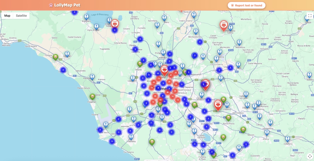
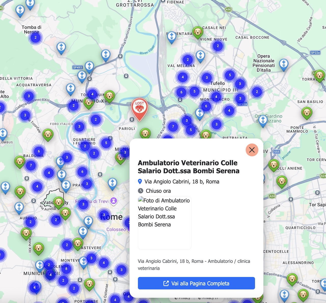
LollyMap is a digital community infrastructure designed to improve access to essential local services and strengthen territorial cohesion across European communities. The platform aggregates and geolocates nearby services, making them easily discoverable through an intuitive map-based interface.
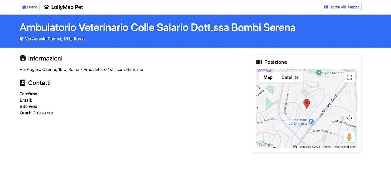
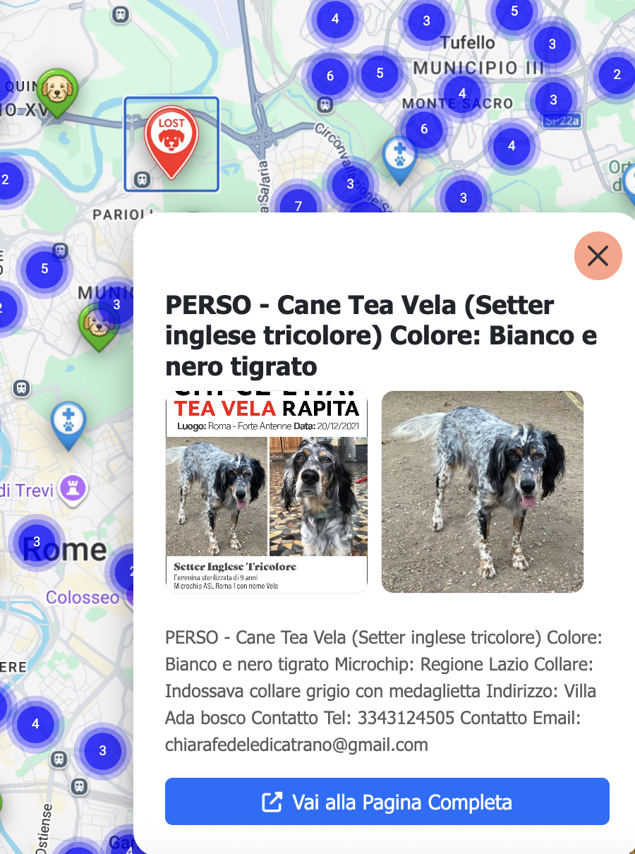
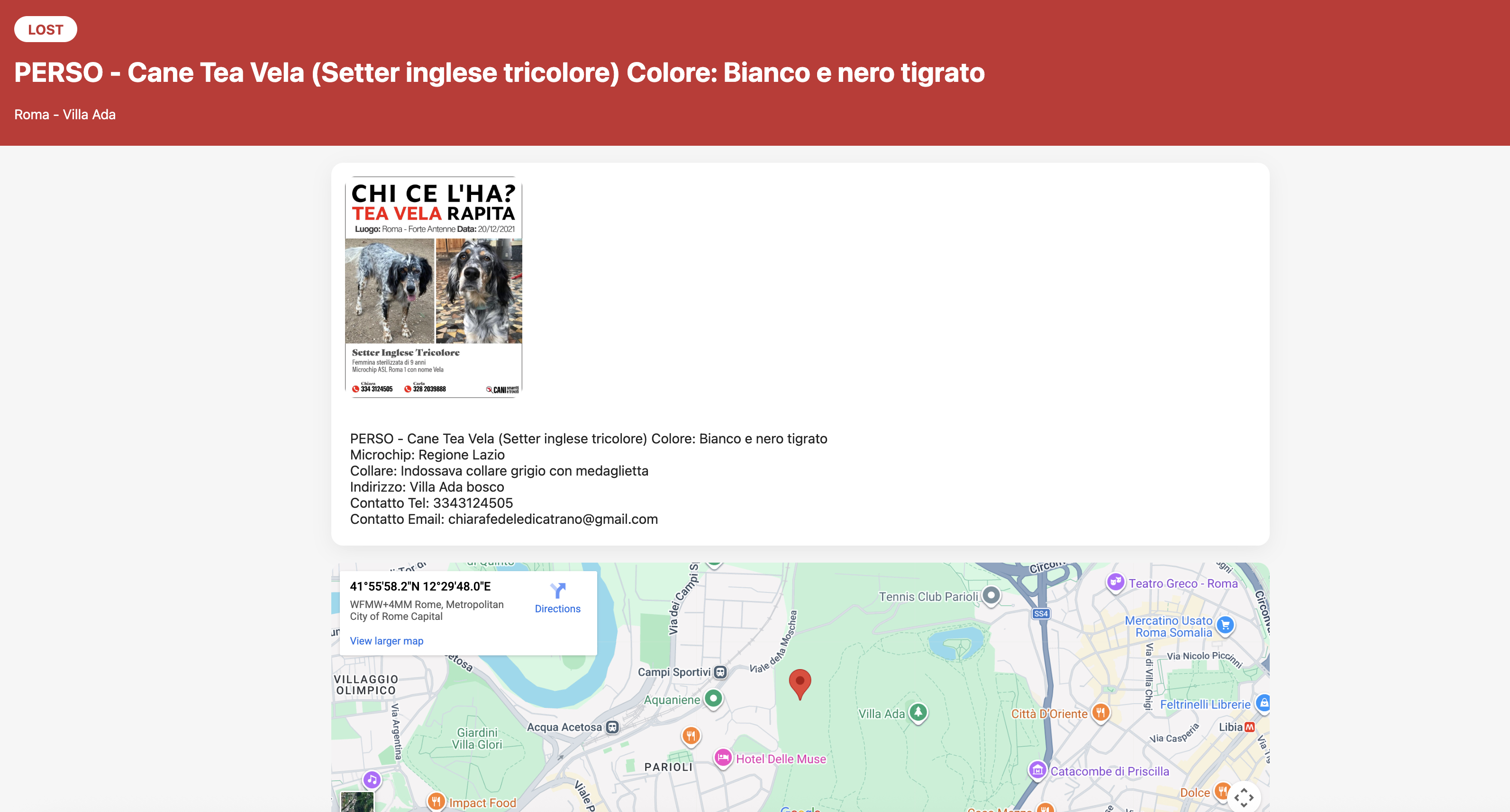
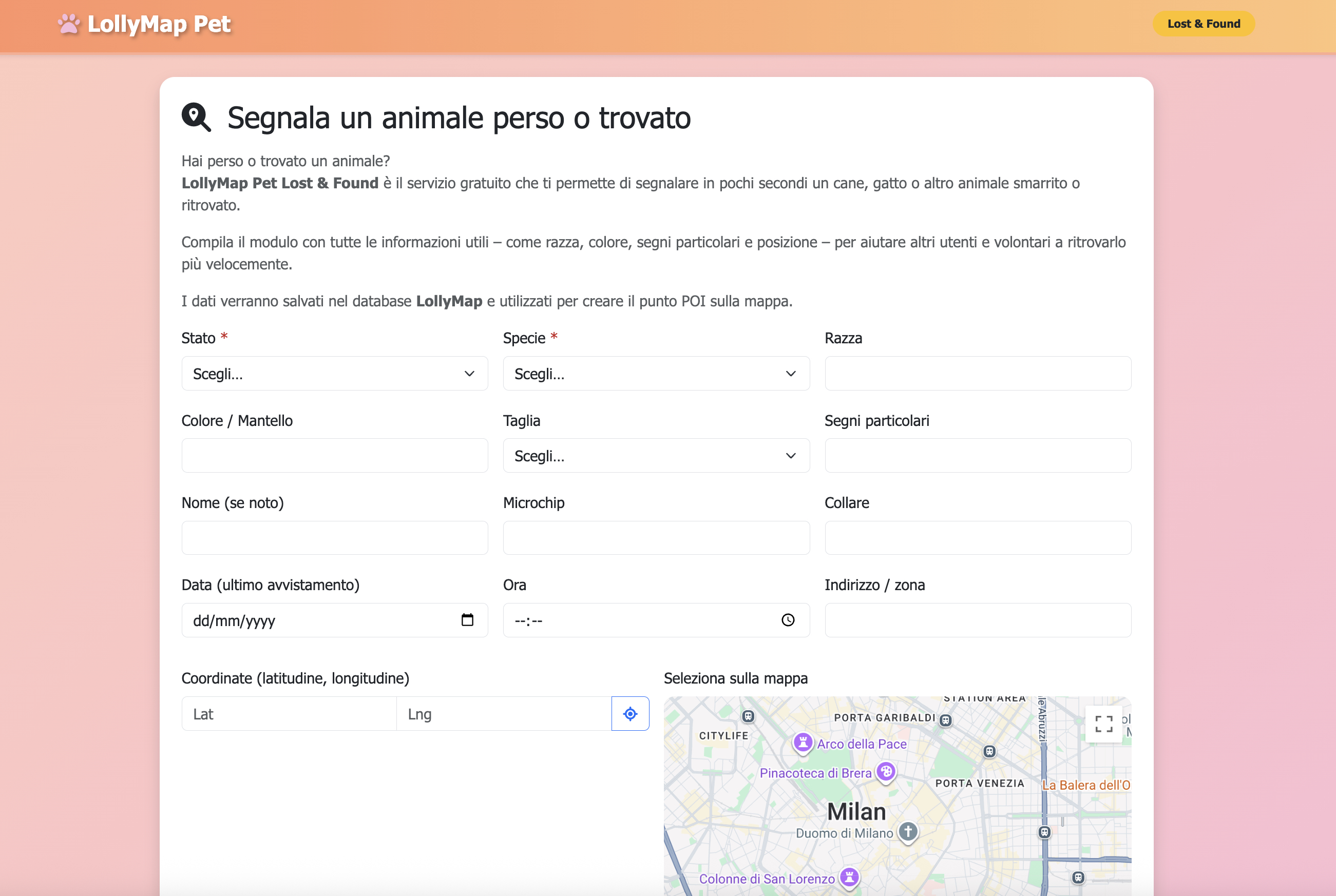
To validate the system and ensure data reliability, the initial implementation focused on categories where information is often fragmented or incomplete. The platform currently includes verified listings of veterinary clinics, animal hospitals, and dog areas. In parallel, a user-driven module has been deployed allowing citizens to report lost or found pets, which are then dynamically visualised on the map to support rapid community response.
This phased rollout demonstrates the platform’s ability to combine structured datasets with community-generated information. Using the same scalable architecture, LollyMap is progressively expanding to additional categories of local services, prioritising those that are typically underrepresented or poorly maintained on existing platforms.
Already operational in Italy, the project shows strong potential to strengthen local service accessibility, improve community responsiveness, and support more connected and resilient territories across Europe.
To validate the system and ensure data reliability, the initial implementation focused on categories where information is often fragmented or incomplete. The platform currently includes verified listings of veterinary clinics, animal hospitals, and dog areas. In parallel, a user-driven module has been deployed allowing citizens to report lost or found pets, which are then dynamically visualised on the map to support rapid community response.
This phased rollout demonstrates the platform’s ability to combine structured datasets with community-generated information. Using the same scalable architecture, LollyMap is progressively expanding to additional categories of local services, prioritising those that are typically underrepresented or poorly maintained on existing platforms.
Already operational in Italy, the project shows strong potential to strengthen local service accessibility, improve community responsiveness, and support more connected and resilient territories across Europe.
LollyMap originated from the practical observation that reliable information about nearby local services is often scattered, outdated, or difficult to access. This gap becomes particularly evident in everyday situations where timely local knowledge is essential.
The project was therefore conceived as a pragmatic and incremental digital infrastructure. Rather than attempting broad initial coverage, the implementation deliberately started with service categories where the need for reliable, structured data is particularly evident. Verified veterinary clinics, animal care facilities, and public dog areas were prioritised as the first operational datasets.
At the same time, a participatory layer was introduced through a lost-and-found pet reporting module, enabling citizens to actively contribute information that is immediately visualised on the platform. This approach allowed early real-world validation of both the technical architecture and the community engagement model.
Following this successful initial phase, the platform is now progressively expanding to additional points of interest and local services, with particular attention to categories that remain underserved by existing digital platforms. The project continues to evolve through iterative deployment, maintaining a strong focus on reliability, usability, and territorial impact.
The project was therefore conceived as a pragmatic and incremental digital infrastructure. Rather than attempting broad initial coverage, the implementation deliberately started with service categories where the need for reliable, structured data is particularly evident. Verified veterinary clinics, animal care facilities, and public dog areas were prioritised as the first operational datasets.
At the same time, a participatory layer was introduced through a lost-and-found pet reporting module, enabling citizens to actively contribute information that is immediately visualised on the platform. This approach allowed early real-world validation of both the technical architecture and the community engagement model.
Following this successful initial phase, the platform is now progressively expanding to additional points of interest and local services, with particular attention to categories that remain underserved by existing digital platforms. The project continues to evolve through iterative deployment, maintaining a strong focus on reliability, usability, and territorial impact.
territorial cohesion
local services accessibility
community resilience
digital inclusion
geolocated platform
LollyMap addresses sustainability through systemic efficiency and better use of existing territorial resources. By making nearby services easier to discover and access, the platform reduces unnecessary travel patterns and helps communities rely more on proximity-based solutions.
From an economic sustainability perspective, LollyMap strengthens small and medium local service providers by improving their digital visibility without requiring heavy marketing investments. This contributes to more resilient local economies and helps maintain essential services within communities.
The platform is designed as a lightweight digital infrastructure with low computational and operational overhead. Its scalable architecture allows gradual deployment across territories without requiring significant physical infrastructure or environmental impact.
In the longer term, LollyMap supports more sustainable territorial ecosystems by encouraging local proximity, reducing information fragmentation, and enabling smarter use of already available community resources in both urban and rural contexts.
From an economic sustainability perspective, LollyMap strengthens small and medium local service providers by improving their digital visibility without requiring heavy marketing investments. This contributes to more resilient local economies and helps maintain essential services within communities.
The platform is designed as a lightweight digital infrastructure with low computational and operational overhead. Its scalable architecture allows gradual deployment across territories without requiring significant physical infrastructure or environmental impact.
In the longer term, LollyMap supports more sustainable territorial ecosystems by encouraging local proximity, reducing information fragmentation, and enabling smarter use of already available community resources in both urban and rural contexts.
LollyMap contributes to aesthetics through a clarity-first digital design approach that prioritises usability, visual calmness, and immediate geographic understanding. The platform avoids visual overload and instead focuses on clean mapping, readable information layers, and intuitive interaction patterns.
The project embraces the concept of functional beauty: a digital environment where users can quickly orient themselves, understand their surroundings, and act with confidence. This is particularly important for community-oriented tools that must remain accessible to diverse population groups.
By visually reconnecting citizens with their local territory through a map-centric experience, LollyMap strengthens the perception of proximity and belonging. Users are encouraged to rediscover nearby services and community resources that might otherwise remain invisible.
In this way, the platform demonstrates how thoughtful digital design can enhance everyday life and reinforce meaningful relationships between people and their local environments, in line with New European Bauhaus principles.
The project embraces the concept of functional beauty: a digital environment where users can quickly orient themselves, understand their surroundings, and act with confidence. This is particularly important for community-oriented tools that must remain accessible to diverse population groups.
By visually reconnecting citizens with their local territory through a map-centric experience, LollyMap strengthens the perception of proximity and belonging. Users are encouraged to rediscover nearby services and community resources that might otherwise remain invisible.
In this way, the platform demonstrates how thoughtful digital design can enhance everyday life and reinforce meaningful relationships between people and their local environments, in line with New European Bauhaus principles.
Inclusion is embedded in LollyMap’s core architecture and user experience. The platform is designed to minimise digital barriers through a simple geolocated interface that can be used without advanced technical skills, making local information accessible to a broad spectrum of citizens.
The project promotes territorial inclusion by giving visibility not only to large organisations but also to small local service providers that often lack strong digital presence. This helps reduce asymmetries in service discoverability and supports more balanced local ecosystems.
The participatory lost-and-found reporting module further strengthens inclusion by enabling citizens to actively contribute information that benefits the wider community. This transforms users from passive consumers of information into active contributors.
Because the platform is lightweight and scalable, it can be progressively deployed in lower-density and underserved areas where access to structured local information is often limited. This makes LollyMap a practical tool for advancing inclusive digital territorial infrastructure across diverse European contexts.
The project promotes territorial inclusion by giving visibility not only to large organisations but also to small local service providers that often lack strong digital presence. This helps reduce asymmetries in service discoverability and supports more balanced local ecosystems.
The participatory lost-and-found reporting module further strengthens inclusion by enabling citizens to actively contribute information that benefits the wider community. This transforms users from passive consumers of information into active contributors.
Because the platform is lightweight and scalable, it can be progressively deployed in lower-density and underserved areas where access to structured local information is often limited. This makes LollyMap a practical tool for advancing inclusive digital territorial infrastructure across diverse European contexts.
Participation is integrated into LollyMap through its community-driven data layer. Citizens are not only users of the platform but also contributors, particularly through the lost-and-found pet reporting module, which allows real-time community input.
Early users have actively contributed reports and feedback that helped validate both usability and practical relevance. This bottom-up interaction informed iterative improvements in interface clarity, data validation workflows, and notification mechanisms.
The participatory model is intentionally lightweight to lower the barrier to contribution while maintaining data reliability through moderation and structured data workflows. This balance enables meaningful civic engagement without compromising information quality.
As the platform expands, the same participatory logic can be extended to additional categories of local services, progressively strengthening community ownership and local ecosystem awareness.
Early users have actively contributed reports and feedback that helped validate both usability and practical relevance. This bottom-up interaction informed iterative improvements in interface clarity, data validation workflows, and notification mechanisms.
The participatory model is intentionally lightweight to lower the barrier to contribution while maintaining data reliability through moderation and structured data workflows. This balance enables meaningful civic engagement without compromising information quality.
As the platform expands, the same participatory logic can be extended to additional categories of local services, progressively strengthening community ownership and local ecosystem awareness.
At its current stage, LollyMap has been primarily implemented at the local level, focusing on real operational validation within Italian urban contexts. However, the platform has been intentionally designed to support future multilevel integration.
The data architecture allows the progressive inclusion of additional stakeholders such as municipalities, local service providers, and regional ecosystems. This creates the technical conditions for future alignment with local and regional digital strategies.
The project already demonstrates how a lightweight civic digital infrastructure can complement existing territorial information systems without requiring heavy institutional deployment. This interoperability-ready approach is particularly relevant for European contexts characterised by fragmented local data landscapes.
The added value of this approach lies in its ability to start locally while remaining structurally prepared for broader regional and cross-border expansion.
The data architecture allows the progressive inclusion of additional stakeholders such as municipalities, local service providers, and regional ecosystems. This creates the technical conditions for future alignment with local and regional digital strategies.
The project already demonstrates how a lightweight civic digital infrastructure can complement existing territorial information systems without requiring heavy institutional deployment. This interoperability-ready approach is particularly relevant for European contexts characterised by fragmented local data landscapes.
The added value of this approach lies in its ability to start locally while remaining structurally prepared for broader regional and cross-border expansion.
LollyMap is inherently transdisciplinary, combining expertise from digital engineering, geospatial design, user experience, and community-oriented service modelling.
The technical architecture integrates database engineering, geolocation technologies, and scalable web infrastructure to ensure reliability and performance. At the same time, strong emphasis has been placed on usability design and behavioural simplicity to ensure accessibility for non-technical users.
The project also reflects elements of social innovation, as it addresses real community coordination challenges through digital means. The lost-and-found module, for example, combines technical implementation with community behaviour dynamics and local ecosystem awareness.
This combination of technological, design, and social perspectives enables LollyMap to function not only as a technical platform but as an evolving piece of digital civic infrastructure aligned with New European Bauhaus principles.
The technical architecture integrates database engineering, geolocation technologies, and scalable web infrastructure to ensure reliability and performance. At the same time, strong emphasis has been placed on usability design and behavioural simplicity to ensure accessibility for non-technical users.
The project also reflects elements of social innovation, as it addresses real community coordination challenges through digital means. The lost-and-found module, for example, combines technical implementation with community behaviour dynamics and local ecosystem awareness.
This combination of technological, design, and social perspectives enables LollyMap to function not only as a technical platform but as an evolving piece of digital civic infrastructure aligned with New European Bauhaus principles.
LollyMap is designed around a sustainable freemium and service-visibility model. Basic access for citizens remains free, ensuring broad public utility and community adoption.
Revenue sustainability is expected to derive primarily from premium visibility services for local businesses and service providers that wish to enhance their discoverability within specific geographic areas. This model aligns economic incentives with the platform’s core mission of strengthening local ecosystems.
Additional future revenue streams may include data services for territorial analysis, white-label deployments for municipalities or local networks, and optional advanced features for professional users.
The platform’s lightweight infrastructure and modular architecture keep operational costs relatively low, supporting long-term financial sustainability even during gradual geographic expansion. This balanced model allows LollyMap to maintain public value while developing a viable economic foundation.
Revenue sustainability is expected to derive primarily from premium visibility services for local businesses and service providers that wish to enhance their discoverability within specific geographic areas. This model aligns economic incentives with the platform’s core mission of strengthening local ecosystems.
Additional future revenue streams may include data services for territorial analysis, white-label deployments for municipalities or local networks, and optional advanced features for professional users.
The platform’s lightweight infrastructure and modular architecture keep operational costs relatively low, supporting long-term financial sustainability even during gradual geographic expansion. This balanced model allows LollyMap to maintain public value while developing a viable economic foundation.
LollyMap has been designed from the outset for high transferability and replicability across different geographic and institutional contexts. The core architecture is modular and data-agnostic, allowing new territories and service categories to be added with limited technical overhead.
The phased deployment model—starting with high-need service categories and progressively expanding coverage—can be replicated in other cities, regions, and rural areas. This methodology is particularly suitable for territories where local information is fragmented or poorly structured.
Because the platform relies on a combination of structured datasets and community-generated inputs, it can adapt to varying levels of data availability across regions. The lightweight infrastructure also makes it suitable for lower-density areas where heavy digital investments are not feasible.
In the medium term, LollyMap can be transferred to other European contexts, supporting municipalities, local ecosystems, and community networks seeking to improve proximity-based service accessibility and territorial resilience.
The phased deployment model—starting with high-need service categories and progressively expanding coverage—can be replicated in other cities, regions, and rural areas. This methodology is particularly suitable for territories where local information is fragmented or poorly structured.
Because the platform relies on a combination of structured datasets and community-generated inputs, it can adapt to varying levels of data availability across regions. The lightweight infrastructure also makes it suitable for lower-density areas where heavy digital investments are not feasible.
In the medium term, LollyMap can be transferred to other European contexts, supporting municipalities, local ecosystems, and community networks seeking to improve proximity-based service accessibility and territorial resilience.